
-
 3969 Hits
-
 81.18% Score
-
 13 Votes
|
|
Mountain/Rock |
|---|---|
|
|
43.20987°N / 4.79781°W |
|
|
Hiking, Skiing |
|
|
Spring, Summer, Fall, Winter |
|
|
7064 ft / 2153 m |
|
|
Overview
 Cabeza Las Monas as seen from the Cabeza Los Tortorios ascent
Alongside the dominating peaks of Macizo Central of the Picos de Europa there are some minor summits which are, however, worth a try and should not be forgotten. Often named Cabeza or Cabezon (head) these summits offer easy hikes for those who don´t want to climb or scramble and nevertheless have great views on the big peaks.
The Cabeza Los Tortorios (named Cabezon de los Tortorios on some maps) and the Cabeza Las Moñas are such summits. They belong to the ridge which runs northeast from Peña Castil, one of the higher and well known peaks of the Macizo Central.
Cabeza Los Tortorios (2153 m) is located northeast of Peña Castil and north of Collada (Collau) Camburero. It has a steep and impressive south face down to Canal del Fresnedal, which runs down to Vegas de Sotres in the river Duje valley. The north face, however, are steep meadow slopes (Cuesta Sierra), dropping down about 1.500 m of altitude difference into the valley of Bulnes.
Cabeza Las Moñas (2074 m) is located east of Cabeza Los Tortorios, separated by a col above the beautiful and romantic ruins of the former Majada Las Moñas; an enchanting place outside our normal world ….
This Cabeza is a 50 m long, south – north orientated ridge, of which the southernmost point is called El Coteron (2065 m). Cabeza Las Moñas shows steep south and east faces down to the valley of River Duje and gentle meadow slopes to the west (Vega Las Moñas). The rocky north slopes down to Canal de las Moñas need some easy scrambling.
Both Cabezas can be climbed easily together with Peña Castil on one day. They are nice hikes and an interesting ski tour on their own.
Getting There
 Majada La Terenosa, Naranjo de Bulnes, Neveron de Uriellu
Trailheads are below Sotres at the Invernales del Texu (also named Invernales de Cabao) or Pandebano parking area above Invernales del Texu.
You reach these trailheads from the north via highway A 8, Oviedo – Santander.
From Arenas de Cabrales follow road number AS-264 to Poncebos and road number CA-1 to Tielve and to the switchback before you enter the village of Sotres. At the switchback take the dirt road to the left, entering the Duje valley. Follow the road to Invernales de Cabao / del Texu and park your car there.
For Pandebano take the right hand dirt road crossing Invernales de Cabao and the Duje river. This road climbs the east and north slopes of Duje valley in some switchbacks to Majada la Roble. Continue on this (bad) dirt road until you reach Pandebano parking area at Fuente del Mont near Cabañas de Canero.
Routes Overview
Pandebano routeFrom Pandebano parking area follow the trail in western direction up to the Collado Pandebano. Take the left hand trail ascending to the Majada and Refugio de la Terenosa.
At the first shack or about 100 m before reaching it leave the trail to the left and ascend off-trail the northern slopes in the direction of the already visible Canal de las Moñas. After about 100 m of altitude gain you should find the first cairns and a small foot track which will become better and better the higher you get. The trail leads you to the Majada de las Moñas.
You can climb Cabeza Las Moñas directly by ascending the steep meadow and talus slope of the Cabeza. Alternatively follow the trail up to the col between Cabeza Las Moñas and Cabeza Los Tortorios. Use the east ridge to El Coteron and the short connecting south ridge to Cabeza Las Moñas.
For Cabeza Los Tortorios follow the trail from the Majada de las Moñas up to the above described col. There is a small trail traversing the north slopes of the connecting ridge El Coteron – Cabeza Los Tortorios. Gain a small col south of point 2038 m of the Adrados map (see Maps & Guide Books section) until you reach the northwest ridge of Cabeza Los Tortorios with a small notch. The trail descends to Collada Camburero and leads up to Peña Castil. Leave the trail at the notch and follow the easy northwest ridge up to the summit.
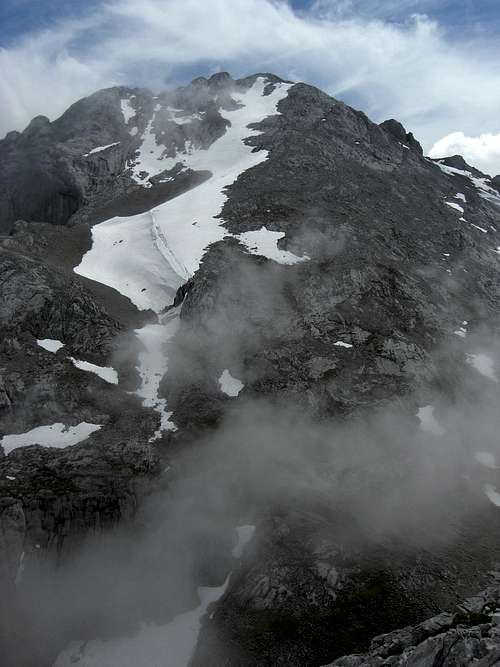
 Canal de las Monas as seen from Collado Pandebano Canal de las Monas as seen from Collado Pandebano |  Pena Main as seen from Canal de las Monas Pena Main as seen from Canal de las Monas |  Both Cabezas and some fog as seen from Pena Castil Both Cabezas and some fog as seen from Pena Castil |
Vegas del Toro – Collada Camburero route
Start at the Invernales del Texu (or de Cabao) parking area. Follow the road along river Duje until you reach the Vegas del Toro cabins. Ascend in western direction on a trail north of the Moñetas creek into the Canal de Fresnedal, first south, then north of the Camburero creek, until you reach Collada Camburero (with the possibility to summit Peña Castil). At the col take the right hand trail which ascends to the notch in the Tortorios northwest ridge. Climb Cabeza Los Tortorios via this northwest ridge and traverse to Cabeza Las Moñas by using the full ridge traverse or by using the trail, traversing the north slopes to the col between Cabeza Los Tortorios and Cabeza Las Moñas.
 Dwarf daffodils on the slopes of Majada Las Monas Dwarf daffodils on the slopes of Majada Las Monas |  Saxifraga (?) blossoms near Cabeza Los Tortorios Saxifraga (?) blossoms near Cabeza Los Tortorios |  Violets alongside the trail of Canal de las Monas Violets alongside the trail of Canal de las Monas |
Ridge traverse
The ridge traverse between Cabeza Los Tortorios and Cabeza Las Moñas is an off-trail traverse on sometimes steep meadow slopes with some easy rock slabs, a bit of talus and (!) steep, near perpendicular rock faces to the south and east. The traverse should only be done with good visibility.
Ski routes
The Adrados map (see Maps & Guide Books section) shows two ski routes:
One from Majada de la Terenosa through Canal de las Moñas to the Majada de las Moñas. From there both Cabezas can be climbed with skis via the north slopes.
From the notch in the Tortorios northwest ridge (see the hiking routes) you can ski down to Collada Camburero and climb Peña Castil.
The second ski route starts at Vegas del Toro and uses Canal del Fresnedal up to Collada Camburero and to the notch in the Tortorios northwest ridge to get on both Cabezas.
Red Tape & Accommodation
 Naranjo de Bulnes as seen from the Tortorios ascent
Red Tape
Both Cabezas are part of the Parque Nacional de Picos de Europa. The entrance is free. I did not see any special restrictions for visitors and even the official internet site does not show any.
Tents are allowed in the National Park above 1.600 m height one hour before sunset until one hour after sunrise.
Accommodation
You find accommodation at Bulnes, Sotres, Arena de Cabrales and the surrounding villages.
Nearby Mountain huts:
Refugio de la Vega de Uriellu (Refugio J. D. Ubeda)
Refugio de Aliva
Refugio de la Terenosa
Gear & Mountain Condition
 Pena Castil as seen from the Cabeza Los Tortorios
The Cabezas can be climbed nearly the whole year round.
For hikers the normal routes are open from early summer to late autumn / early winter, depending on the snow conditions.
You need normal hiking gear and good shoes for this outing. Look out for sudden fog on the ridge and in the Majada de las Moñas region: orientation is nearly impossible with dense fogs!
The ski, snowboard or snowshoe touring during winter and spring need full avalanche and winter gear and a good knowledge of the actual avalanche situation.
Current Weather for Sotres:
Maps & Guide Books
Maps:The best topographic map of the region I know:
Picos De Europa, Macizos Central Y Oriental (Los Urrieles y Andara) MM001, Central and Eastern Massif - Topographic Walking Map, scale 1 : 25.000, Adrados Editions
For more information see the Adrados website (only in Spanish).
A good hiking map, not too detailed but sufficient for hikers:
Parque Nacional de Picos de Europa; 2 Mapas Excursionistas, Escala 1 : 40.000, Macizo Central y Oriental; Macizo Occidental; Editorial Alpina
 Cabeza Los Tortorios as seen from Majada de las Monas Cabeza Los Tortorios as seen from Majada de las Monas |  Canal de las Monas with Pena Main view Canal de las Monas with Pena Main view |
Guide Books:
Standard guide book in English:
Robin Walker: Picos de Europa, Walks and Climbs, Cicerone guide
Spanish publications and more maps can be purchased in the towns and villages round the Picos.