
|
|
Mountain/Rock |
|---|---|
|
|
43.60945°N / 111.36926°W |
|
|
Hiking |
|
|
Spring, Summer, Fall |
|
|
8440 ft / 2573 m |
|
|
Overview
Chicken Peak is located in the Big Hole Range above Fleming Canyon which is accessed right off of ID-31. A very well groomed trail will take you to the top of this summit. This peak is a good one to get done when you are heading past this direction. This is not the type of summit you go out of your way to do by itself. Not the most exciting peak. It is possible to get this one done along with Black, Liars, and Piney Peak. We did this with Liars and Piney since we had already accomplished Black earlier in the season. This is a very popular trail. Very active with dirt bikes and during certain times of the season, guided hunting.
Getting There
From Swan Valley, travel along ID-31. Not sure about the mileage but after several miles you will turn left to get onto the road that take you through Fleming Canyon. An old abandoned house sits at the entrance of the road. You will need a 4WD and high clearance vehicle to make it up this road. It is not well groomed and deep grooves are carved into the road. We ended up having to hike the road from the highway which added an additional 6 miles round trip to our jouney. If you can get the vehicle, it is well worth it. The road will eventually come to an end as it turns into the trailhead. You will want to park a couple hundred yards back in any clearing that you can find. Not really any places to park up by the trailhead. It is too tight to fit most vehicles.
Route
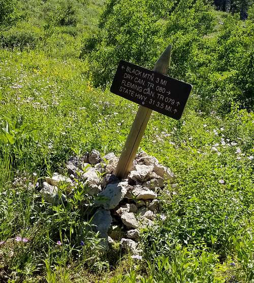
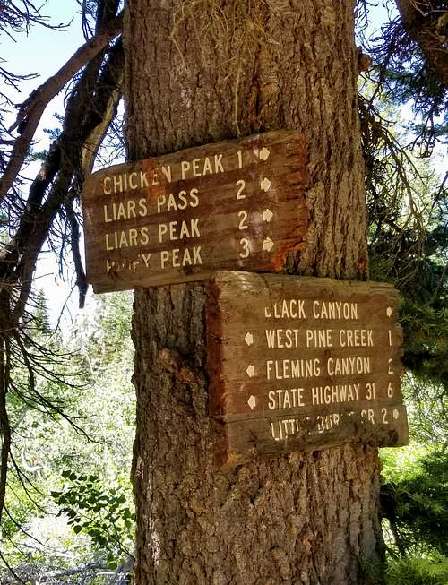
You will begin the hike at the trailhead and simply follow the trail up to the first fork (.5 miles). Turn right and head towards Black Mountain. A sign sits at the fork pointing the correct way on the trail. Chicken Peak is about 4 miles from this sign. You will simply follow the trail past Black Mountain. At the second fork, you take a left. The trail from here will take you straight to the summit.
Roundtrip from the Trailhead: Approx. 8 Miles
Roundtrip from the HWY: Approx. 16 Miles
Red Tape
No red tape in this range
When to Climb
It is best to climb this spring thru fall once the snow is cleared. We did an earlier hike up to Black Mountain when the trails still had a good amount of snow on them and it made for a harder journey but the choice is up to you.
Camping
No designated camping sites on in the area. Plenty of places to backpack too if your looking to stay overnight in the surrounding area. We camped off the road by the HWY. Plenty of space to park a car and set up a tent.
External Links
I always use Idaho Climbing Guide as a reference for many of my hikes. Link below for a description on this one:
https://www.idahoaclimbingguide.com/bookupdates/chicken-peak-8440-by-margo-mandella/