
|
|
Mountain/Rock |
|---|---|
|
|
43.63020°N / 111.3578°W |
|
|
Teton |
|
|
Hiking |
|
|
Spring, Summer, Fall |
|
|
9019 ft / 2749 m |
|
|

Overview
Located in the Big Hole Mountain range, this peak is a beauty in a beautiful area. Ranking #73 on Idaho's top 100 prominence peak list, it has a prominence of 2260'. It is also one of the two peaks that you need to climb if you would like to claim the Teton county highpoint. Why two? When two peaks have an almost identical height in the same county, county highpointers feel that you need to get both to count the county. So besides Piney Peak, you need to get the other one as well and in this case, Garns Mountain with 9016' is the other one you need to visit. A SP page for Garns Mountain can be found HERE.The Big Hole mountain range is relatively unknown outside of the local area but much of the area is being utilized by ATV's and dirtbikers. Yet, I found this area to be one of those hidden Idaho gems with beautiful meadows and pleasant topography. History is tied to early trappers such as John Colter who is thought to be the first "european" to see it in 1808. John Colter was a member of the Lewis and Clark expedition who returned to this area after finishing the expedition and became a trapper.
 From Red Butte
Getting There
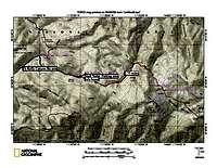
Heading east from Idaho Falls, head for the Kelley Mountain Ski Area (easy to locate with an Idaho highway map). You have pavement until the ski area, go past the ski area (the road is a bit washboarded initially) and then look for a junction with FS 218 and FS 217 (GPS 43.6386 -111.6083 nad 27 6250 elev). Go left on 218 and follow it for about ten miles until it meets up with FS 226 (GPS 43.6761 -111.4665 7000' elev). Turn right on FS 226 and drive up this road about 1.5 miles until you see the parking area and vault toilet. An information board is placed at the start of the trail (ATV road). Unless you have an ATV or motorcyle, park here.Other ways to get to Piney Peak. See this reference: Cohp TR As you will note from the mileage and elevation gain listed, this isn't the easiest way to get to Piney Peak. Hopefully someone who is familiar with other trails will add that information to this page, particularly if there is a shorter approach & access.
 Trailhead
SP member Biglost added this information about another way in:
"ATVs are allowed in much of the Big Holes. This small range has been sacrificed to the motorized crowd, in order to close off much of the other areas in the region. Not a terrible trade off in my opinion.
The route I use goes up Black Canyon, and returns by way of Burns Canyon. I stash a bicycle at the bottom of Burns and peddle the road back to Black Canyon Trailhead.
Still a trip of +-15 miles, but it is all downhill coming down Burns Canyon."
Route
From the TH shown on the map, it is roughly 15.50 miles round trip. Elevation gain both ways is 3500 feet (not exact, just a guesstimate). I did Piney Peak by including a hike first to Garns Mountain, then over to Piney Peak and back to the TH via Red Butte. Overall, it was an effort of at least 20 miles and over 5000 feet of elevation gain (counting all the ups and downs both ways).To just do Piney Peak, count on the 15.50 miles for the round trip effort and an elevation gain, counting the ups and downs of both ways of the 3500 foot figure noted above. You could certainly include Red Butte (the county highpoint of Madison county) in this hike which would add some more elevation but not a significant amount considering the fact that you have to gain elevation anyway up and out of 1000 springs
 Blacktail Pass
ATV road 077: You will be on this ATV road from the trailhead to Blacktail Pass. Expect to be sharing this road with ATV'ers and dirt bikers
and it is best to step off the road when you hear them coming. Weekends would be particularly busy so be aware that this isn't an area where you will be alone, at least along this section. Just a note: The information sign at the trailhead is a bit confusing and we found that 077 was the key road. You will stay on 077 if you wanted to go to Garns Mountain but for Piney, you will leave it at Blacktail Pass. Once at Blacktail Pass, look for an ATV road going directly up to your right. Avoid this road but instead look for a trail that cuts off from it a short way from its beginning. This is the trail that will take you all the way to the base of Piney Peak. Once you get to the base of Piney Peak (see map),
you will then figure out the best way cross country to the summit. You can skirt the rock slide to the left and work your way through the trees to the ridge will then allow you to find easy access to the summit. It is about a 1200 gain from the XC waypoint with a distance of about a mile. You can cross the rock slide area and go up from there but it is easiest if you stay to the left and follow use trails and common sense to get to the ridge.
 Route
RouteRoute idea: SP member Biglost mentioned "The route I use goes up Black Canyon, and returns by way of Burns Canyon. I stash a bicycle at the bottom of Burns and peddle the road back to Black Canyon Trailhead.
Still a trip of +-15 miles, but it is all downhill coming down Burns Canyon."
Summit visitors and other summit stuff
Not many actually make the effort to climb this one but according to Lists of John, ten have indicated they made the summit. Peakbagger shows a few less.Dennis Poulin posted a peakbagger trip report HERE.
If you are one of the few who do climb this one, I'd appreciate it if you would make an entry in the summit log at the left side of this page and relate your experience(s).
Red Tape
None that I am aware of.Local Ranger station:
Palisades Ranger District
Targhee National Forest
3659 East Ririe Highway
Idaho Falls, ID 83401 Phone: 208-523-1412
For more information, contact:
USDA Forest Service
Caribou-Targhee National Forest
1405 Hollipark Drive
Idaho Falls, Idaho 83401
Contact: Joanna Wilson
Phone: (208) 524-7500
2006 information
 Rounded summit
Camping
You could car camp at the trailhead or many of the "dispersed" camping locations found throughout the forest area. Several developed campgrounds are available near Heise and a forest service campground (primitive) is located at Table Rock.Description: 5800-foot elevation. 9 campsites including a group site which can accomodate up to 200 people. Trail from campground leads north through Hawley Gulch.
Location: From Idaho Falls, go 21 miles north on US 26/Ririe Highway. Turn left on Helse Road; turn right, go past Mountain River Ranch, and go right again after crossing the Snake River. Follow signs to Kelly Canyon Ski Area, then take Forest Road 218 for 1 mile to the junction of FR 217, bear right, and travel 1.25 miles to the campground.
 Area
AreaWeather

Route maps & the Endurance Challenge

Dean - Aug 5, 2009 9:42 am - Hasn't voted
Helpful infoDan Robbins maintains a great Idaho resource at his webpage known as Idaho Summits.