
-
 9833 Hits
-
 79.78% Score
-
 11 Votes
|
|
Mountain/Rock |
|---|---|
|
|
46.53241°N / 9.15298°E |
|
|
Mountaineering, Skiing |
|
|
Spring, Summer, Winter |
|
|
9973 ft / 3040 m |
|
|
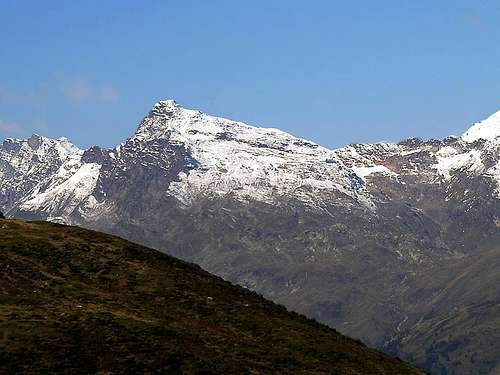
Overview
From Rheinwaldhorn (Adula) a long ridge goes toward east-north-east , being the northern boundary of the Splugental,one of the valleys where from Rhein comes down.
This ridge has some interesting summits, first one is Güferhorn followed by Höberghorn, Schwarzhorn, Lorenzhorn
and ends with the Chilchalphorn known also as Chirchalphorn and Kirchalphorn (see map)
 ....
.... 
This is the first mountain one can see coming out from S.Bernardino tunnel coming from Ticino, and the last one can see,
on the right, when arriving from Chur.

subset of CNS 267 S.Bernardino (1965)
It looks elegant, with a fine east side, a well designed series of slopes that looks like created for ski-mountaneering
From its north ridge starts a chain whose south side is full of fine ski-mountaneering escursions on minor summits :
Wänglispitz, Tallihorn, Valserhorn, Bärenhorn and on ... till the Brugshorn and Piz Beverin.
 |  |  |  |  |
Getting There
Two different approaches and routes :from south :
coming from Lombardia and Ticino or from Chur
along the San Bernardino highway, on the northern side of the tunnel, starting point is Hinterrhein (1620 m)
ski-mountaneering (and summer hiking) route :
from Hinterrein up to Kirchalp (2082m) then toward east along fine slopes to get the northern ridge just a little before the summit (4-5 hours)
from north :
coming from Chur or Andermatt (crossing the Oberalp pass)
along the road of Vorderrhein from Chur to Flims, Ilanz, then, along the Valsertal till Vals-Platz (1757m)
from Vals-Platz, along the road to Valè, then enter the Peilertal, cross Peil and toward south till the Fanellagletscher
About at 2650 m toward east to gain the Kirchalplücke (2813m) then along the northern ridge to the summit (5-6 hours)
maps :
CNS 267 - S.Bernardino
CNS 257 - Safiental
 |
When To Climb
summer for hiking ... bur WINTER for ski-mountaneeringfantastic immediatly after a snow fall, very little (or NO) danger of avalanches.
 |  |  |  |