
|
|
Mountain/Rock |
|---|---|
|
|
46.63117°N / 8.96862°E |
|
|
Hiking, Mountaineering, Skiing |
|
|
Spring, Summer, Fall, Winter |
|
|
10394 ft / 3168 m |
|
|
Overview
The Piz Vial 3168m is a mountain in the southern part of Switzerland, in the canton Grisons. He's close-by the boarder of the cantons Gisons (Graubünden) and Ticino (Tessin). This mountain is near by the villages Disentis, Sumvitg and Campo and at the End of the Sumvitg valley (Val Sumvitg). In the region there are three huts: the Terri hut 2170m, Scaletta hut 2205m and the Motterascio hut 2193m. In the south of Piz Vial you find the Greina-pass and the unique landscape Greina. The Greina high plain is a beautiful hiking area. In the north is still a small glacier, the Valdraus glacier (Glatscher da Valdraus).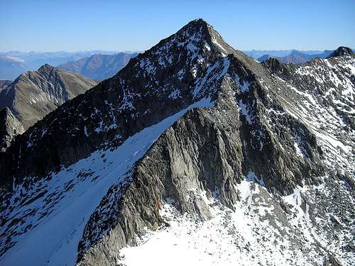 Piz Vial 3168m
 Unique landscape Greina- The Greina high plain
Route & Difficulty
Summer route:The Starting point is the Scaletta hut 2205m (or the Terri hut 2170m). On a hiking trail you go the Greina alpine pass 2355m (Passo della Greina). Now pathless over the southwest side of Piz Vial to the summit, without great difficulties.
Difficulty: L (F) or in the new scale: T5
Route 291 in the guide book “Bündner Alpen 2, vom Lukmanier zum Domleschg” from Manfred Hunziker
Winter/spring route with ski:
With ski you go the same route as in summer. See above.
Ski Difficulty: ZS (AD) ¦ Route: 255 ¦ 1040 metres in altitude
Guide book “Skitouren Graubünden” from Vital Eggenberger
Online maps for Switzerland:
www.mapplus.ch
Map Search - Online Maps
Accommodations
* Scaletta hut 2205m: Link to Scaletta hut* Terri hut 2170m (Camona da Terri) : Link to Terri hut
* Motterascio hut 2172m (Capanna Motterascio): Link to Motterascio hut
 Terri hut
Getting There
By public transport:SBB & RHB- Gotthard railway to the village Biasca. Then you take the yellow bus and drive to Olivone and Campo in Blenio valley (Valle di Blenio). Campo or Pian Geirett are the starting point, to go to the Scaletta-hut.
Online train&bus schedule (public transport Switzerland): SBB schedule
By car:
From Bellinzona get the highway to Biasca and follow the indication to Olivone. Then follow the road to Campo in the Blenio valley (Valle di Blenio). In summertime is possible to drive until "Pian Geirett", there is a narrow street from Campo to Pian Geirett. Campo or Pian Geirett are the starting point, to go to the Scaletta-hut.
Online Route scheduler: route scheduler in english and TCS.ch
Weather, climate and snow conditions in Switzerland
Federal Office of Meteorology and ClimatologyWeather SFDRS
Meteo News.ch
Swiss Federal Institute for Snow and Avalanche Research Davos: www.slf.ch
Links
Switzerland tourism: www.myswitzerland.comGisons tourism: www.graubünden.ch
Ticino tourism: www.ticino.ch
Greina foundation: www.greina-stiftung.ch
Good and favorable accommodations: www.rooms.ch
In Memory of Cyrill Rüegger
 A note from the SP staff
Cyrill Rüegger, the member we all used to know as Cyrill and Digitalis, died on June 13th 2009 in an avalanche on the summit ridge of Piz Palü together with his wife Tanja and a common friend. They were swept down by the avalanche into a couloir underneath the east summit and died instantly. Their bodies were retrieved from the Palü Glacier by helicopter a day after the accident.
Cyrill joined SP in March 2006 and soon was one of the most prolific contributors on the site with almost 70 mountain and 5 range pages to his profile. He was an accomplished climber, bagging almost 1000 summits in not quite seven years. Among them are 35 4000ers and 272 3000ers, almost all of them in his home country Switzerland.
While contributing a lot on SP, Cyrill's real internet home was www.hikr.org where he contributed 585 mountain profiles and reports in his native language German. Cyrill also posted on www.bergsteigen.at and other climbing sites, often under his real name but also under the pseudonym Digitalis. He was a botanist by profession and also contributed his knowledge about medical plants to different websites. Cyrill will be greatly missed by all.
This page will be kept in honour of Cyrill, one of SP's most prolific members and most active mountaineers.
Rest in peace, brother!
The picture above was taken on the summit of Matterhorn on July 28th 2007.