
-
 19215 Hits
-
 92.04% Score
-
 37 Votes
|
|
Mountain/Rock |
|---|---|
|
|
46.53916°N / 10.63386°E |
|
|
Bolzano Alto Adige |
|
|
Mountaineering, Scrambling |
|
|
Summer |
|
|
11630 ft / 3545 m |
|
|
Overview
Cima Vertana/Vertainspitze 3545 m
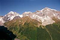
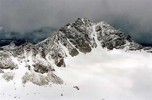
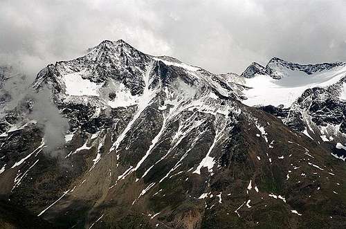
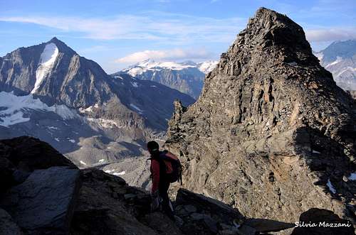
Cima Vertana/Vertainspitze 3545 m is a powerful and regular rocky pyramid lying in Italian South Tyrol (Südtirol / Alto Adige), in the Ortles-Cevedale Group, opposite to the "king" Ortles. It is a dark rock massif, with two well visible summits. The Southern one is 3389 m high, and the main summit is 3545 meters high. The mountain Vertainspitze is surrounded by valleys from three sides. They are the following: Valle di Solda (Suldental) to the west, Valle di Zai (Zaytal) with the glacier Vedretta di Zay-Zayferner (Vedretta di Zai) to the North-West and Rosimtal with both glaciers Vedretta di Rosim-Rosimferner and Vedretta di Lasa-Laaser Ferner to the SouthEast. To the North-East it's situtated the saddle Angelusscharte (3337 m), which separates Vertainspitze from the mountain Hohe Angelus-Spitze (L’Angelo Grande), 3521 m. To the South-East a second saddle, called Rosimjoch (3288 m) separates Vertainspitze from the mountain Schild-Spitze (Punta di Scudo), 3461 m.

The first ascent of Vertainspitze was achieved in 1865, by Julius von Payer and J. Pingerra.
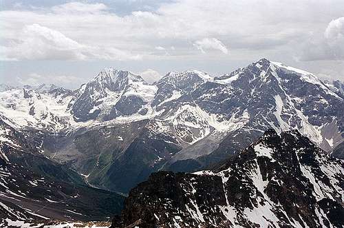
Today Vertainspitze stays in shadow of the ice giant Ortles, but is a really interesting summit of moderate difficulty. From the peak and on the way it appears a fine view to the “big three” of the Ortles Group: Ortles, Cevedale and Gran Zebrù-Königsspitze.
One of the most attended routes to the summit begin at the Kanzel lift station (2350 m) across Val Rosim. From Sulden you can take a chair-lift to Kanzel or walk-up on foot (one and half hours). The other Normal route starts from Rif. Serristori.
 |
 |
 |
Getting There
The best outgoing point to Cima Vertana is the village of Solda/Sulden 1907 m. There is no train station. Solda is best reachable by car (or bus): - From Lombardia: from Milan by SS36 towards Lake Como, later by SS 38 towards Sondrio, through Passo dello Stelvio, in Gomagoi turn right towards Sulden.
- From Bolzano Alto-Adige: Bolzano – by road SS38 Merano – Schlandres – towards Passo dello Stelvio, before pass, in Gomagoi turn left towards Sulden.
- From Southern Germany: Munich – Garmisch – Landeck – Reschenpass, then in Italy road SS 40 via Mals, later SS 38 via Schlunders to Passo dello Stlevio, before pass, in Gomagoi turn left to Sulden
- From Austria: Innsbruck – Landeck - Reschenpass, in Italy road SS 40 via Mals, later SS 38 via Schlunders towards Passo dello Stlevio, before pass, in Gomagoi turn left towards Sulden.
 |
 |
 |
Routes overview

- South-East Ridge (Normal Route from Rosimtal) Difficulty: F
It's the easiest way to climb Cima Vertana. The route starts from the Kanzel chairlift upper station and follows the path on the right crossing to the hillside and reaching the bottom of the Rosim valley, where an easy path rises up to the plateau situated in front of the seracs of the Rosim Glacier and to the Passo di Rosim (Rosimjoch) 3288 m
From Solda take the Kanzel chairlift to the upper station 2400 m. First take the path n. 12 on the meadows of the Val Rosim to the south, then soon, at the junction, take the path n. 13 Eastwards. It climbs the moraine, reaching the tongue of the glacier Rosimferner, where the signpost ends (2900 m). You continue on traces of passage or freely on scree and boulders following the cairns to reach the Passo di Rosim 3288 m. Pay attention to a rough passage on rock near a crevasse. At about 3200 meters, turn to left, towards a shoulder with an arrow indicating the direction; then you cross a long snowfield. Following the summit ridge (easy rocks up to UIAA I-II) and snow fields, keeeping yourself the middle or along the South edge reach the summit cross (3545 m, about 3.30). You return on the same way.
- North-East Ridge ("Walterweg" or Normal Route from Rif. Serristori) Difficulty: PD
Interesting and fine route, well frequented also because of the proximity to the refuge. The "Walterweg" starts from the Passo dell'Angelo (Angelus-Scharte) 3337 m, a high col located between the Angelo Grande on the South left and Cima Vertana on the right.
The direct ascent to the Passo dell'Angelo is no longer a recommended route (danger of rockfalls), the col is reached across the summit of Angelo Grande, climbing it along the "Reinstadler route", then crossing to the Passo dell'Angelo, thus combining the ascent to two summits. Start behind the refuge in northeast direction following moraines and crossing up to the base of the obvious rock wall at the base of the NW rigde on wich it runs the Reinstadler route. Climb up on steep rock terrain meeting some stretches equipped with some cables that will help you, getting the ridge. Soon it appears to the right (West) an impressive view to Cima Vertana with its NW ice covered face. Always following the rocky ridge, which requires some more demanding passagges (I-II), through this latter we reach the summit ridge and proceeding eastwards we reach the magnificent summit of Angelo Grande. From the top start tro descend towards the S to reach the Passo dell'Angelo. From here follow the "Walterweg" on the NE ridge of Cima Vertana, ignoring the first four rocky hills of the ridge by keeping the snow slopes of the southern face. Resumed the ridge, follow it with fairly easy climb and after a thin snowy stretch you reach the North summit and from this in a few minutes the South Summit, which is the highest one.
Descent: reversing the route or better following the SE ridge to Rosimtal
- Nordwestgrat (Northwest ridge) Difficulty: AD
From Kanzel lift station (2350 m) take the marked route nr 12, towards the Refuge Serristori (Düsseldorferhütte), 2721 m. From the hut head to right, to the saddle Angeluscharte (3337 m), later climbing (up to UIAA III-IV) by northwest ridge with remains of glacier to the summit. Caution: the ridge is not artificial secured, there is no via ferrata (as described in some guides)! After the rock fall in 1966 the ridge is more difficult as before.
- North Face is a classic but difficult ice climb: 500m ascent of the route, up to 80° steepness. You find route description on www. bergsteigen.at. (added by Mathias Zehring).

Red Tape
No permits or fees for climbing are required. The mountain lies in the area of Parco Nazionale dello Stelvio (National Park Stilfser Joch).
No particular restrictions in hiking and climbing inside this area. Respect the general rules regarding the National parks. The whole fauna and flora is protected. Don’t disturb fauna and other mountaineers and hikers’ peacefulness with every kind of noise.
Official site of the Stelvio National Park
Huts and accomodation

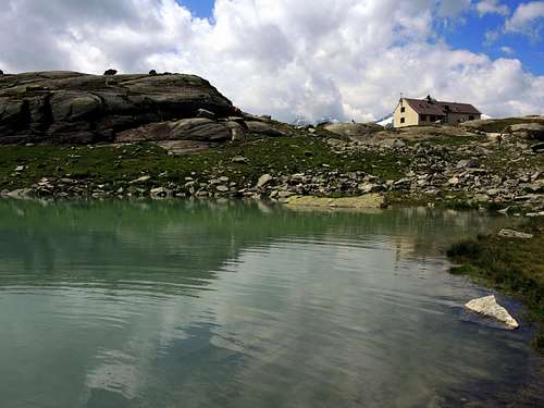
The only hut near Vertainspitze (Cima Vertana) is the Düsseldorfer Hütte, called also Zaytalhütte, in Italian - Rifugio Serristori. It lies on 2721 m in Zaytal (Valle di Zai). This hut exists since 1892 and today belongs to Milan section of CAI (Club Alpino Itatliano). Düsseldorfer Hütte is managed by Reinstadlers, a famous family of alpine guides in Ortler area. The hut is reachable from the Kanzel lift station, on the marked route nr 12. Details (in German or Italian only) are to find here: Rifugio Serristori/Duesseldorfer Huette
Check also the dedicated page by lodewijk here on SP: Düsseldorferhütte / Rifugio Serristori.
You will find other possibilities of accomodation in the village of Solda/Sulden. There are many hotels, pensions and guest houses of different classes, partially with camping sites. They are to find here:
or here: (choose "Unterkunftverzeichnis"):
When To Climb
The best season is July to September. Fresh snow and bad weather conditions are possible also in high summer.
Meteo and Mountain Conditions
The actual weather conditions could be proofed here:
Meteo Alto Adige
Site of South Tyrol
or here: Site of Ortler area in Sulden
You can always see the alpine weather on this website: Weather by OeAV (Austrian Alpine Club)
Guidebooks and Maps

"Ortles-Cevedale" by Gino Buscaini - Collana Guide dei Monti d'Italia TCI-CAI
Kompass: Nr 72, Ortler/Ortles-Cevedale, 1:50.000
Kompass: Nr 636, Ortler/Ortles-Stilfser Joch/Passo dello Stelvio, 1:25.000
Tabacco: Nr 08, Gruppo Ortles - Cevedale/Ortlergruppe, 1:25.000