
-
 6995 Hits
-
 84.27% Score
-
 18 Votes
|
|
Mountain/Rock |
|---|---|
|
|
44.06309°N / 115.0897°W |
|
|
Boise |
|
|
Hiking, Mountaineering, Scrambling |
|
|
Summer, Fall |
|
|
9606 ft / 2928 m |
|
|
Overview

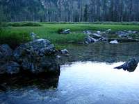
Cony Peak lies deceptively close to a maintained trail in the Sawtooth Range, yet the summit cannot be seen from the typical approach via the upper reaches of the South Fork of the Payette River Trail. The peak is situated in the southwestern portion of the range and consequently is slightly drier, even in the upper tarns and valleys. The summit is reached via a direct, steep, and rugged off trail scramble up Garden Creek, which is shown on the USGS map, but typically dries up by July. From the trail, it's a brutal 3779 feet gain in just over 1.5 miles through loose rock, narrow canyons, and small section of solid rock. Just to the south of the summit lies a beautiful hidden tarn valley.
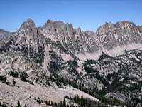
The summit of Cony Peak surprisingly has a USGS benchmark, and before July of 2007, no summit register existed. The steep scrambling is rewarded with some of the best and most unique views of the Sawtooth Range. To the north, Blue Rock Dome, Warbonnet, Tohobit, and the Monte Verita Ridge are prominent. To the distant southwest are the elusive and intimidating Rakers, but the real temptress and unknown gem is just 3/4 of a mile south of Cony: Garden Peak (Peak 9765). It's north face is impressive and unexplored.
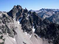
The Cony Peak ridgeline is a collection of unexplored and undocumented technical towers to the south, and a more mellow ridgeline of high points to the north. A climb up Cony offers the possibility of creating a circuit through the upper reaches of a spectacular and seldom visited off trail valley. From the summit, descend the direct north slopes to the unnamed lake at 8746 and follow that side valley down into the Goat Creek drainage at the direct base of Tohobit Peak. Another more aggressive option is to descend from the summit east to Cony Lake and follow that spectacular valley down to Goat Creek. You'll be able to explore Oreamnos, McWillards, Meadow and Three Lakes. Reaching these lakes is an achievement given the rugged off trail location tucked away in the upper reaches of Goat Creek. If you see anyone else, you should be absolutely shocked.
Routes
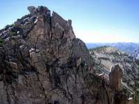
Northwest Ridge (Class 4)- follow the South Fork of the Payette Trail to Garden Creek (not obvious). Leave the trail and climb steeply through loose and solid rock, staying left when the valley splits. Bypass a nearly vertical rock section (dry waterfall) on the left side. Continue steeply up a chute that veers slightly left but emerges on a spectacular ridgeline just northwest of the summit. Traverse the ridge over large blocks to the summit. There are large loose blocks on this route, so a helmet and traveling side by side is almost required. There are many sections of easy 4th class along the way.
From the Grandjean Trailhead: 9.6 miles and 5585 feet gain (one way)
SouthEast Ridge via Garden Creek (Class 3)- follow Garden Creek (usually dry by mid summer), over mostly loose rock to the prominent hidden valley south of the summit. Scramble to the saddle just southeast of the summit and boulder hop your way to the summit.
From the Grandjean Trailhead: 9.5 miles and 5513 feet gain (one way)
East Side Climb (Class 3)- follow the trailless and rugged Goat Creek to the upper reaches at Cony Lake. Scramble easily up the east slopes to the summit. Goat Creek is particularly rugged in the lower sections and becomes more easily passable above 8000 feet around the alpine lakes. This is a rugged, highly scenic and adventurous route that would be tough to accomplish car to car in one day.
From the Iron Creek Parking Area: 10.9 miles and 5084 feet gain (one way)
Getting There

From the Grandjean Trailhead, follow the South Fork of the Payette River Trail south past the Baron Creek turnoff. You'll need to cross Baron Creek which can be difficult before June. For years there was a large log crossing, but that has been washed away and now you'll need to wade across Baron Creek and it's tributaries at 1.2 miles, then Goat Creek (easier) further south on the trail. Near mile 4.7 there's an old grave (marked on the USGS map and with a small wooden sign). Near here is also some natural springs. Further south on the trail are spectacular low angle waterfalls over smooth rock. Be sure to stock up on water before leaving the trail area as the Cony Peak ridge and area usually has no water source from July to November.
Road Approach
Take the Grandjean Road off ID-21 just past Lowman for 7 miles.
The dirt road is passable by any vehicle.
The approach roads are usually closed until May.
Check the road conditions at: Idaho Transportation Department
Conditions and Season
Conditions may vary greatly. Access is typically from May to November.
The Sawtooths can be the coldest region in the lower 48 during the winter, but this particular section of the range is warmer and drier because of it's lower starting elevation ~5000 ft and it's aspect (west to south). Expect dry and hot conditions during the summer months.
Nearby Stanley, Idaho Climate Data:
| Jan | Feb | Mar | Apr | May | Jun | Jul | Aug | Sep | Oct | Nov | Dec | Annual | |
| Average Max. Temperature (F) | 27.0 | 33.7 | 42.5 | 50.3 | 59.9 | 68.4 | 78.7 | 78.4 | 68.6 | 56.6 | 38.1 | 26.0 | 52.4 |
| Average Min. Temperature (F) | -0.5 | 0.3 | 9.7 | 20.3 | 28.3 | 33.9 | 36.0 | 34.0 | 27.2 | 20.6 | 12.0 | -0.8 | 18.4 |
| Average Total Precipitation (in.) | 1.64 | 1.33 | 1.02 | 1.02 | 1.17 | 1.16 | 0.59 | 0.59 | 0.78 | 0.92 | 1.46 | 1.55 | 13.24 |
| Average Total SnowFall (in.) | 16.9 | 13.2 | 10.2 | 3.4 | 0.9 | 0.2 | 0.0 | 0.0 | 0.4 | 1.7 | 10.4 | 14.6 | 71.9 |
| Average Snow Depth (in.) | 18 | 20 | 15 | 6 | 0 | 0 | 0 | 0 | 0 | 0 | 2 | 8 | 6 |


External Links
National Weather Service Current Forecast for Stanley