
-
 3459 Hits
-
 74.01% Score
-
 4 Votes
|
|
Route |
|---|---|
|
|
52.51561°N / 117.37662°W |
|
|
Mountaineering |
|
|
Summer |
|
|
One to two days |
|
|
Class 3 |
|
|
Alpine II |
|
|
II |
|
|
Overview
Coronet Mountain is an exciting mountain with several steep ridges, formidable faces and an elegant north glacier in southern Jasper National Park. Coronet Mountain has a reasonable height (3152m, 10,342 ft.) and is in a fairly accessible remote area, but it sees little attention. This beautiful peak sits just off the edge of the Le Grand Brazeau, a large high elevation plateau covered in thick glacier ice, one of the largest icefields east of Highway 93 in the Canadian Rockies’ National Parks. Coronet Mountain is rarely climbed, and likely has fewer than a dozen summits. First ascent in August 1930 by R. Baring, G. Gambs, K. Gardiner, S. Hendricks, W. MacLaren, P. Prescott, and H. Sampson from Coronet Creek, up main Coronet Glacier then traversed to, and climbed the South Ridge.Coronet Mountain is in the Queen Elizabeth Range, this range is generally west of Maligne Lake and north and east of Maligne River. The range was named in 1953 to commemorate the coronation of Queen Elizabeth II of the United Kingdom. Coronet Mountain was named by Howard Palmer in 1923. The mountain had a snow formation near the summit which resembled the shape of a crown.
Getting There
Jasper National Park joins Banff National Park to the south via the Icefields Parkway. This parkway offers scenic driving, and more importantly, access to some of the best alpine and waterfall ice climbing in the world. The parking areas for all routes is at the Poboktan Creek trailhead, approximately 165 km north of the Trans Canada Highway or 70 km south the town of Jasper.
Approach
A bit of an odd parking area and access to the trail. Back in 2005 the bridge that crosses Poboktan Creek had the railings torn off by raging flood waters. When I climbed Mt. Brazeau in 2007 you could still use the bridge deck for crossing the creek. Now the entire bridge structure has been removed and will not be replaced. Park in the large parking lot just south of the creek and highway crossing, head back to the highway, hike north across the highway bridge and then to the Sunwapta Warden Station. Behind the station and near the horse coral there is a sign for the trail.Follow the Poboktan Creek trail for about 6.5km to the obvious intersection meeting the turnoff for Poligne Creek. There is good signage for this turnoff. Follow the trail north-west along Poligne Creek for about 2km, near NTS UTM grid reference 743148 (52.483367, -117.378188) exit the trail and head due north into the drainage than originates from between Replica Peak and Coronet Mountain.

|

|

|
| Poligne Creek turnoff | Head to avalanche camp |
From south, view to Coronet Mtn. Main summit in centre |
Head up stream towards Coronet as far as you wish, we are approaching in the dark and decided not to proceed all the way to our original destination, the col north of Coronet, and instead bivyed at 726185 (52.51017, -117.402607). The west slopes of Coronet Mountain provide mostly treadmill and loose scree all the way to the north-west ridge crest. Luckily we found some large, well frozen snow patches nearing the top to lessen the slog. Large sections of steep slabs are present and would be difficult to ascend, stick to the scree and large boulders to reach the ridge. From the valley aim for the lowest of three highpoints along the ridge; the most southern highpoint (difficult to see) is the main summit, the middle point is the lower north summit and the other is a good target.
Route Description
- North-West Ridge, Alpine IISecond ascent of the peak, August 1930 by E. Clarke, W. Cleveland, M. Davis, J. Forkes, B. Jefferson, F. McCulloch, M. MacLeod and D. Sharpe. From camp in upper Coronet Creek, then to the col on north end of Coronet Mountain then to west scree slopes.

|

|

|
|
We used snow patch just left of centre to mid flat ridge |
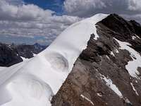
Summit on far right, round top under blue sky |
Let the slog begin |
Since we gain west slopes from the north col, we were further north than required, but we found a nice raising scree ramp. From the alpine meadows west of Coronet a more direct line of the scree could reduce this distance. We travelled up a couple of large snow patches near the top of the slope and made the North-West Ridge on a flat, middle section of ridge in the first photo above.

|

|

|
| Getting close to snow patches | View to Mt. Mary Vaux | View to Mt. Warren & Mt. Brazeau |

|

|

|
|
On NW ridge, view to first summit |
Nearing first, fore summit | Just below first summit |
As you gain height of the west slopes the views get better, and of course, once on the North-West Ridge the view to Mt. Warren and Mt. Brazeau is excellent. On the ridge the first section is fairly flat, then solid scree and boulders up the lower north summit. Cool cornices along the east side of the ridge as you gain height to the fore summit. Once on the lower summit the view to the main summit is impressive. A relatively short ridge section of moderately steep snow on glacier ice leads to the summit. The snow ranged from 5 to about 15 cm deep. A few small crevasses were found, but easy to step over. A slightly lower rock summit had a collapsed cairn, but no register. Worried about cornices, we belayed to the higher snow summit, no cornice, just a nice rounded snow cone.

|

|

|
| First view to main summit | View from summit back to ridge | On descent, looking back |

|

|

|
|
Kevin roped and leaving fore summit |
Kevin gunning for the top |
On descent, back to first
summit |

|

|
|
| Steven on highest snow summit | The boys on the rock summit | View back on descent |
We descended the same route and made quick time back to our bivy, long hike back to the parking lot.
Essential Gear
Climbing boots, crampons and helmet (mainly for loose scree on descent). Standard glacier travel and crevasse rescue gear; depending on snow coverage and comfort/skill level, pickets or ice screws, pulleys, locking carabiners and carabiners, slings and prussiks. Probe is useful for detecting crevasses.If ski or winter mountaineering avalanche rescue gear is essential; beacon, probe and shovel.
High altitude camping gear for bivy camp. We had overnight temperatures of -1 C (30 F) in mid July. Rain/snow storm shell, down jacket, waterproof climbing (ski) boots and good camp food.
Reference
Boles, G.W., Kruszyna R. & Putnam W.L. (1979). The Rocky Mountains of Canada South. 7 th edition. New York: American Alpine Club, Alpine Club of Canada. Out of print