
|
|
Mountain/Rock |
|---|---|
|
|
44.78240°N / 115.219°W |
|
|
Valley |
|
|
Hiking |
|
|
9705 ft / 2958 m |
|
|

Overview
This is truly a very remote mountain in the heart of a huge wilderness that is located in the state of Idaho. Home to an old lookout structure (still standing), it provides a destination to look forward to and yet, it is as demanding a hike as any that the author of this page has ever been on. Located in an area that has suffered extensive fire damage over recent years, it requires that you pay attention to your water needs and the hundreds of downed timber that you have to step over or work around. Located in the largest wilderness area in the lower 48, the Frank Church River of No Return area, Big Baldy is about as isolated as you can find.Big Baldy is the county highpoint of Valley County and is also a mountain that comes in at #26 on the top 100 Idaho prominence peak list. Both of these designations are reason enough for some of us to seek out the summit and if a person is pursuing both county highpoints and prominence, then it is just one of those mountains that you have to visit.
Others who have done this hike have listed the distance as anywhere from 32 to 36 miles and that you will have a total elevation gain of anywhere between 7300 feet to 10000 feet. When you take into account that the actual vertical elevation distance between the trailhead at 8000 feet and the summit at 9700 feet, you will then realize that there is a lot of ups and downs to contend with. You will gain almost as much elevation on the return as you do going in. I'll explain all of this in the route section.
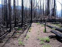
What a magnificient area this must have been before the fires destroyed almost everything. Remaining small areas of trees exist and lovely meadows filled with flowers are treats along the way but much of the hike is through burnt forest and stepping over and around downed timber is part and parcel of the overall experience. You feel like a visitor to an alien planet some of the time and this is a trail where it is nice to have companionship on. The trail follows a ridgeline the whole way as it undulates up and down as it makes its way to the main water source 12 miles from the trailhead, Buck Lake.
Getting There
From I-84, take Idaho highway 55 north to the town of Cascade, a great place to get gas and supplies before heading east on highway 22 to Warm Lake, 26 miles away. This is a nice paved highway and Warm Lake provides several campgrounds to choose from along with a small lodge and store. Head east about ten miles towards Landmark and the pavement will end leaving you with just under 17 miles of forest service road to get to the trailhead.
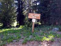
Just beyond where the pavement ends, you will see a sign indicating a left for the Landmark airport and Mud Lake and a right that will take you to the Deadwood reservoir and Stanley. Take the left, cross a small bridge and zero your odometer. Passing the small airport and Mud Lake (they'll be to your right), follow FS road 447, always taking the most obvious road as signs are few and far between (many burned in the fires). Stay on FR 447 to the trailhead. Landmarks along the way are a junction at around 3.8 miles, signed "Artillery Dome" - keep left; a bridge over signed "Burntlog Creek" at 7.5 miles; and three more bridges at 11.3, 12.6 miles and 14 miles (new concrete one) Soon after this bridge, the road takes a switchback and gains elevation for the next three miles to the trailhead, signed as the Buck Creek trail. (odometer mileage may vary from vehicle to vehicle so these are "in the ballpark" type of figures). There are some forks with roads of various quality, many unsigned, but the main road is always obvious. The trailhead is reached 17 miles from Landmark junction. I found a spot to park about 150 feet or so from where the sign for Buck Creek was located (on the right). The TH is at 8000 feet and GPS coordinates 44.7611 -115.4410 (nad 27)
Route section
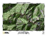
Four maps have been added and hopefully will give you an idea of the route we took in. Rather than write a separate route page, this section will hopefully convey a feel for the hike in and out. Since there is a trail the whole distance, you would just have to pay attention in those sections where the fire and deadfall have really altered the situation. We lost the trail a few times but always managed to find it again within a 100 feet or so as it pretty much stays to the ridge or near it the whole distance.In the section below, I have links to the three trip reports that we used to help us plan our route. In our determination, we ended up with over 32 miles hiked (round trip) and close to 9000 feet of elevation gain. In the reports below you will note that elevation gain is listed by the others as
7300'
9600
10,000'
There are many undulations of just a few feet to up past a hundred feet both ways and they all add up. Both Dennis and I agreed that it was close to 9000' by our determination.I will restudy the maps on my National Geographic Topo program to double check this elevation gain aspect but be aware that on hot days (as we had), water is a very vital element. Both Dennis and I carried full backpacks and had originally planned to perhaps camp just one night but the heat made that third day (and second night of camping) a better way to go for us.
We camped the first night at the small pond just west of Buck Lake and used that for our "basecamp" for going to the summit the next day. After returning to the "basecamp", we packed up and hiked a good 4 miles to where we set up a second nights camp at a saddle near the 8000 foot mark. It was a dry camp just barely off of the trail. On the third day, we finished hiking out and were at Warm Lake Campground by one o'clock in the afternoon. While we are both strong hikers, we felt that the heat took a lot out of us.
Other routes to the summit:
Indian Creek from the Indian Creek Guard station (no info available)
Garden Creek trail from the middle fork of the Salmon river.
 Map 1
Map 1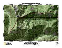 Map 2
Map 2Red Tape
Salmon-Challis National Forest1206 So. Challis Street
Salmon, ID 83467
(208) 756-5100
FS link


Camping
You could bush camp at many places along the way (they present themselves) but the best camping is at either Warm Lake or Pen Basin campground, a small 6 site unit which is just beyond the turnoff that you would take to get on FS road 447.Camping at the trailhead is possible but there aren't really any attractive places to bush camp or car camp.
Weather for Warm Lake Idaho

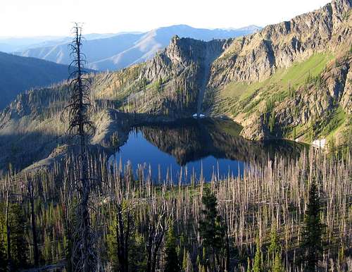 Buck Lake
The hike
 Map 3
Map 3 Map 4
Map 4Dennis and I used Ken Jones trip report for our guide and also referred to Bob Packards report and Dan Robbins report, the three others we knew who had done this trip. Dennis also posted his GPS track from our visit on Peakbagger.com
From Ken Jones TR:
"Backpack up trail 090 to the ridge. Here you intersect a north-south trail. Turn left toward Chilcoot Pass. The trail drops east from Chilcoot Pass; below the basin (water available) it reaches a junction (around 8000 feet) - bear left up through a shallow saddle and down to intersect a road. (Bob Packard found access to this road closed by downed timber at a spot much lower than the trailhead described in this write-up. If it can be driven, you could cut some effort from this trip). Note where this junction is for your return trip, then turn right and walk up the road. At a sharp switchback (around 8300 feet) look for the trail heading left toward Pistol Rock. Follow the trail to a junction in a saddle (around 8700 feet) and bear right. You are now on the Big Baldy Ridge trail, which you can follow all the way to the peak vicinity. The only reliable water between here and the peak is at Buck Lake, where we camped (about 12 miles from the car). Before reaching Buck Lake you will start passing through burned areas. As of August 2001, there had been no trail maintenance since the burn, and there were a lot of downed trees to climb over or around between here and the summit. We did not find the mapped spur trails leading off the ridge. Near the summit, the trail takes the long way around. You can head straight up to the top when conditions look good to you. A register, benchmark, and lookout tower grace the summit."
A Trip Report and a note about animals
Not many people have made the effort to get this one. Peakbagger.com shows about 10 or so people and Lists of John shows about the same.Dan Robbins wrote a Trip Report for this one when he finished up the Idaho county highpoints with this mountain.
Click HERE for that TR.
It was strange not to see any and stranger still not to see many birds. We did see some elk and deer tracks around Buck Lake's little neighbor pond and Dennis spotted some cougar tracks near Chilkoot Pass but the effect of the fires are most likely still being felt.
Springfield Mine
Grandfathered into the wilderness area was this mining operation that is obvious from the Big Baldy ridge trail. See pic
Springfield Mine. See this link for a history
From this resource, comes this information:
An unusual skarn is at the Springfield tungsten mine about 12 miles from the Johnson Creek Road, 14 miles southeast of Yellow Pine in west central Idaho. Access is difficult, the upper half of the access road is rough, rocky and steep. The deposit was mined for the scheelite that occurs in pyrrhotite.
The skarn is dominantly pyrrhotite, marble and small amounts of calc-silicate minerals. Most of the “usual” skarn minerals are absent or present in small amounts only. There is some quartz as small colorless crystals, small milky crystals associated with pyrite and malformed milky crystals in masses. Reddish garnets occur as shattered and pitted euhedral crystals in the contacts of a coarse white marble body.
The contacts sometimes have layers of grains and masses of a black prismatic mineral (a tourmaline?), an unidentified green anhedral to subhedal mineral (probably diopside) and small masses of garnet. There also is a white acicular mineral in layers and masses. This skarn has a small potential for specimens of quartz and garnet, and some of the other minerals.
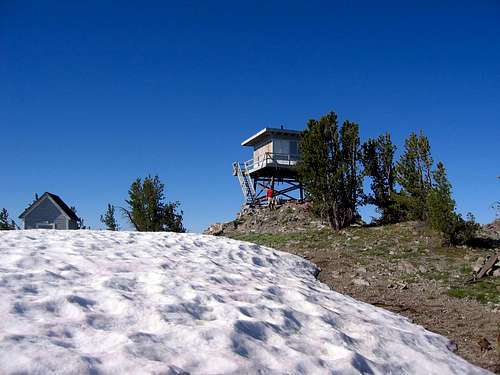
The Lookout


Thanks to mtybumpo for sending a link to this information:
The first structure was a log cabin with cupola in 1925. The present 10' treated timber tower with R-6 flat cab was built in 1959 and is on emergency status. It is located in the Frank Church River of No Return Wilderness.
More pics can be seen at this link (click on lookouts)
Cell coverge: US Cellular worked for Dennis, AT &T did not work for me.
Forest fire devastation

The summer of 2000 was a summer of out of control wildfires that burned over 182 thousand acres, causing much of the devastation that is still remaining in the area that the Big Baldy trail passes through. LINK
More info:
Nearly one-fourth of the Frank Church River of No Return Wilderness burned in the summer of 2000. More than half of it has burned since 1979. Despite the fires, the Middle Fork of the Salmon remains the incredible wilderness river that gives it its world-renowned reputation. "Nothing stays the same," says Ken Stauffer, acting district ranger for the North Fork District this summer. "Fire speeds up the process so people can notice."
Katherine Jones / Idaho Statesman
 Splash of color
Two days or three days? A few thoughts on the matter
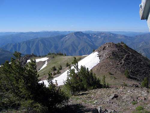
I can agree with Ken Jones (in his trip report cited above in the hike section) that I was glad to have had three days for this one (considering the heat we encountered) but Dennis and I felt that had we planned a bit differently, we could have done this hike in two days. One day in to the mountain, camp there, and then one day out. We would have packed a bit lighter and started a bit earlier in the day. The other thing we would have looked at was how to get to that road that Bob Packard (see the link for his report in the Hike section above) found which eliminated the hike up and over Chilkoot Pass. One note however on that approach, is that a windy day will possibly see burnt trees fall across the roads up there and you need to be prepared to cut and move them if they happen to fall on the road after you have driven as far as you can drive.The key is water. You can get water only at Buck Lake or by melting snow found near the lookout during the time that snow remains there. You can see from a couple of the pics that I posted that a substantial snowfield remained into late July and was probably one of the key water sources that lookouts had when they actively manned that lookout.
mtybumpo - Jul 26, 2009 6:07 pm - Voted 10/10
Big Baldy Lookout.I found a very brief bit of information regarding the lookout you may be interested in. http://www.firelookout.com/id/bigbaldy.html
Dean - Jul 26, 2009 6:47 pm - Hasn't voted
Re: Big Baldy Lookout.That is great Matt, thank you. I'll add that info onto the front page.