
|
|
Mountain/Rock |
|---|---|
|
|
46.62900°N / 12.56100°E |
|
|
Hiking, Mountaineering, Trad Climbing, Scrambling, Skiing |
|
|
Spring, Summer, Fall, Winter |
|
|
8435 ft / 2571 m |
|
|
Overview
 Cima Nord
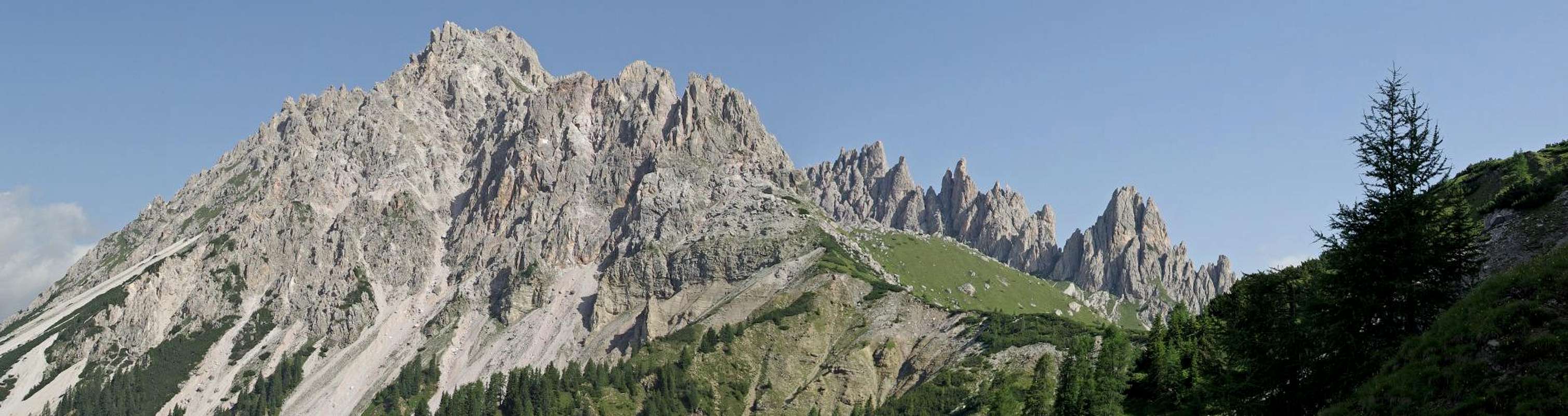
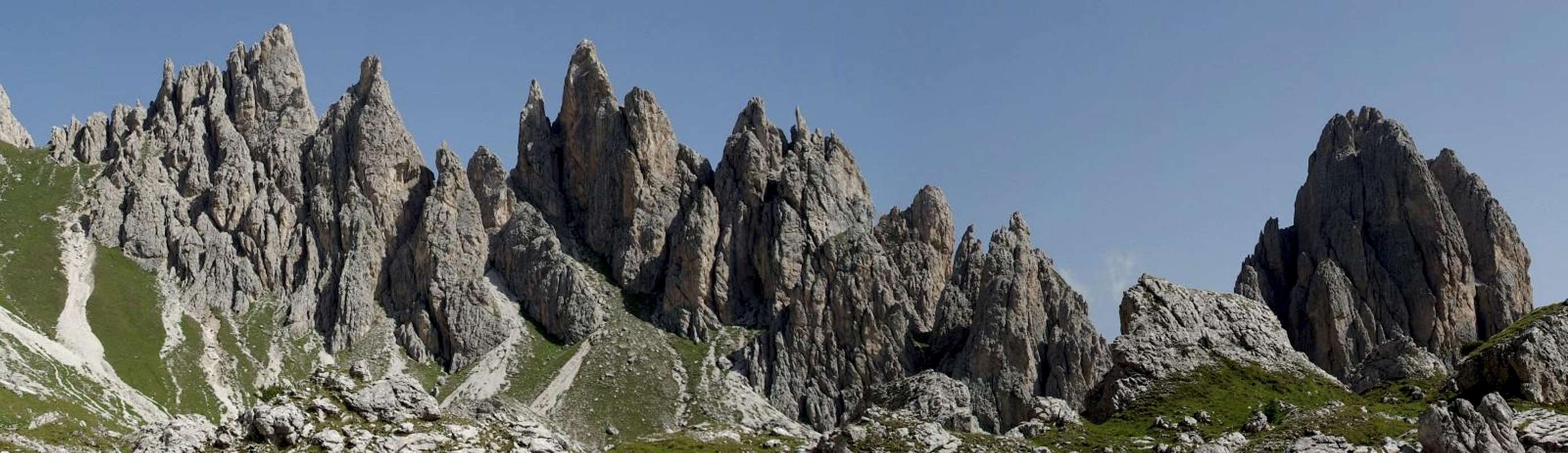
The mountains of the western ridge of the Carnic Alps main chain are well known for their complex geology, they are probably the oldest mountains of the Alps, formed almost totally in the Paleozoic Era between the Ordovician and the Permian age ( 510-250 million of years ago ). The main summits of the group are mostly composed by clay-schists of the Carbonifer age and limestones of the Devonian age. But just in the middle of the chain there are two groups that seem to have nothing to do with all this ancient mountains, two beautiful and not much known dolomitic groups that formed in a later period like some of the peaks of the Southern Carnic Alps: the Crode dei Longerìn and the Rinaldo-Lastroni group. They are both composed mainly by a beautiful dolomitic rock called Dolomia del Serla, originated in the Anisic period of the middle Triassic age ( 240-220 million years ago ) and are characterized by impressive towers, spires and monoliths.
 From Peralba From Peralba |  From Terza piccola From Terza piccola |
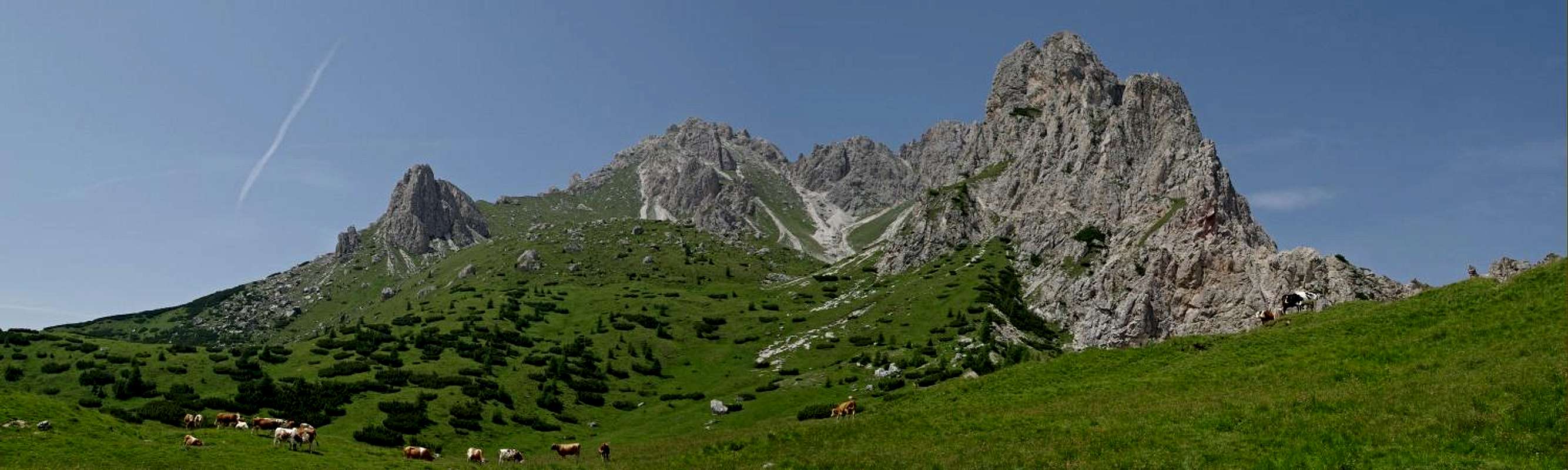
The Crode dei Longerìn can be easily recognized from almost any summit of the Carnic Alps ( and from many of the Dolomiti ), they have a beautiful horseshoe shape and are composed by two main summits ( Croda dei Longerìn Nord, 2571 m and Croda dei Longerìn Sud, 2523 m ) and seven wonderful towers called Torrioni dei Longerìn, numbered with roman numbers ( highest tower VII Torrione dei Longerìn or Torre Austria, 2542 m ). This Torrioni are also known as “I Vescovi” ( the bishops ).
Croda dei Longerìn Sud is usually considered the main summit due to the easy approach ( cross and summit register ). Actually this Cima Sud ( also called Cima della Ferrera, Zima dla Frèra in local language ) is composed by two summits, and the one chosen as main is clearly only a fore-summit of the other, that is 24 meters higher but is more difficult to climb ( the last ten meters have a difficulty around the II degree ). The ascent of the Cima Nord could be a nice a nice climb but due to the bad quality of this dolomitic rock can be hardly recommended.
 Cima Sud Cima Sud |  Cima Sud-Quota 2547 Cima Sud-Quota 2547 |  Cima Nord Cima Nord |
Monte Zovo ( 1943 m ), Monte San Daniele ( 2229 m ), Cima Aiaredo ( 1922 m ), Monte Schiaron ( 2246 m ) and Monte Curiè ( 2035 m ) can also be considered part of the group.
There are two very interesting legends about two of this minor summits: It’s believed that a long time ago all the area of the Val Visdende was a huge lake and Monte Schiaron was a small island with two big iron rings ( Schiarons ) where the boats used to stop. About Monte San Daniele this is what the locals say: “On this mountain the saint used to ride his horse, and once he was riding so fast that He jumped over the mountain and fell on a rock, where the animal left the prints of the feet and of the head, a sign that is still on the mountain”.
This mountains are far from being the most famous or the most interesting for alpinists of the Carnic Alps, so it’s not difficult to understand that are a real paradise for those in search of solitude, wilderness and of course fantastic dolomitic sceneries. Actually this small group, with all its amazing towers and monoliths, cannot be considered less beautiful than many other famous and often overcrowded ranges of the nearby Dolomiti. So far nobody in this area have had strange ideas like building vie ferrate on the Torrioni or an alpine hut on the Piani di Vissada, so this place probably will remain wild and unspoiled for long.
 |
|---|
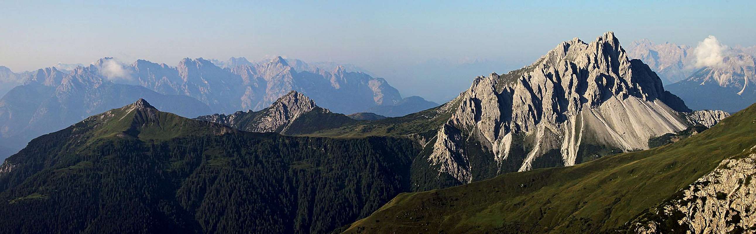
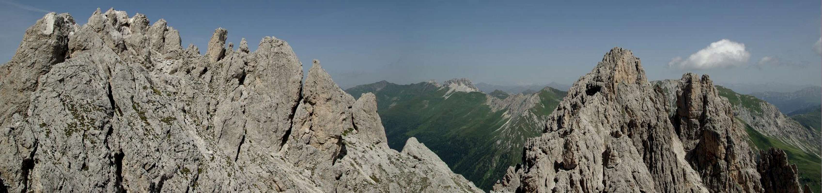
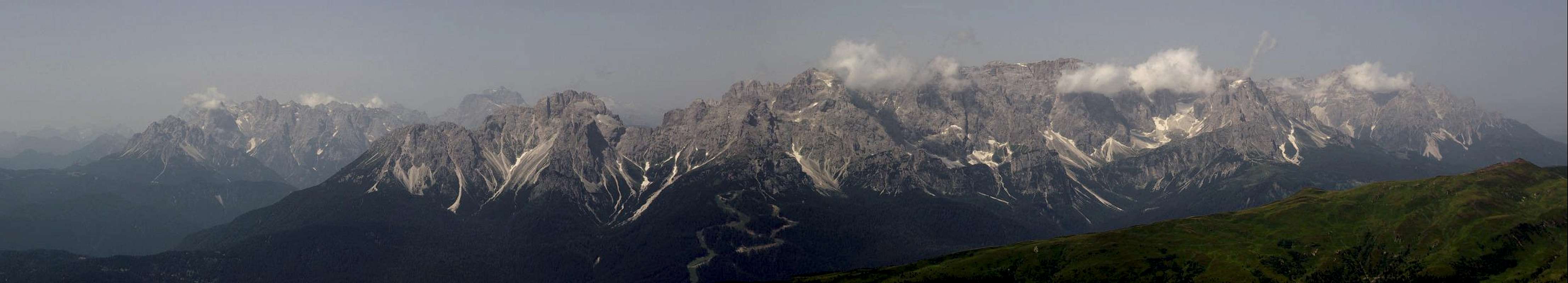
The views from the summits of this group are really fantastic: the Dolomiti di Sesto and the Dolomiti d’Ampezzo just on the other side of the valley, all the ridge of the Southern Carnic Alps with in the background the northern part of the Carnic Prealps, the western part of the Carnic main ridge with very nice views of Peralba, Cima Palombino and Monte Cavallino and the Austrian glaciers of the Hohe Tauern group.
The origin of the name of this mountains is not clear: some say that they took the name from a creek nearby ( Longe=far Rìn=creek ) while others think that the name comes from the latin longara ( narrow and long meadows ).
The Crode di Longerìn during the First World War were part of the Italian firing line so it’s not difficult to find rests of that period. The Italian front line of this area went from Cima Palombino to Monte Lastroni, the Val Visdende was the no man’s land and the Austrian line went from Croda Negra to Peralba.On the summit of Monte Schiaron you can find the rests of the main fortifications of this group.
 |
|---|
 |
|---|
Summit Views
 |
 |
 Brentoni Brentoni |  The cross The cross |  Quota 2547 Quota 2547 |
 Monte Cavallino Monte Cavallino |  Cima Sud Cima Sud |  the Torrioni the Torrioni |
Routes Overview
There are many hiking and climbing routes for all the summits of the group, though the quality of the rock is not very good. Approaches Approaches |  Normal route 1 Normal route 1 |  Normal route 2 Normal route 2 |
This are the main possible approaches for the Piani di Vissada:
a) From Forcella Zovo ( 1600 m ) through Col di Pradetti ( paths 154-165 )
b) From Forcella Zovo through Val di Vissada ( path 169 )
c) From Val di Londo ( bivio Ciadon, 1436 m ) through Passo Palombino ( paths 167-165 )
d) From Val di londo through Valle dei Longerìn ( paths 167-169 )
e) From Casera Melin ( 1673 m ) through Passo Palombino ( path 165 )
Croda dei Longerìn Sud

Normal route ( 1 ): With the approach “a” you reach the Forcella 2073 between Monte San Daniele and the Crode dei longerìn. Once on the other side of the Forcella you turn left pointing at the big basin on the eastern slopes of the group. From there you go up to the grassy slopes on the left until you reach the south-eastern crest of the mountain. There you’ll find some cairns that will bring you shortly to the summit.
Easy route, not marked but quite clear ( there are some tracks almost disappeared ), with much better views of the other. Elevation gain around 1000 meters.


Normal route ( 2 ): With the approach “b” you reach the Forcella Longerìn and from there you follow the marked path n°195 that goes straight up to the ravine between the Cima Sud and the Cima Nord. More strenuous than the other but also not difficult and with very good views of the Torrioni. Same elevation gain.
In my opinion the best route is going up with the first route and going down with second.
If you want to reach the highest summit ( quota 2547 ) you have just to follow the red dots on the right ( if you go up with the marked path n°2 ) just before the main summit. In ten minutes or so you will be on the top. There are ten meters or so of easy climbing ( around UIAA II degree ) not exposed in the last part. From there there’s a better view of the Dolomiti di Sesto and of the last part of the Carnic Main Chain, and also an impressive number of spires of any kind all around.
Croda dei longerìn Nord

Normal route from the south crest: With the path n°195 described before you reach the grassy slope between Cima Sud and Cima Nord, then you turn right and you go up on a steep ravine until you reach the east base of the mountain. From there through another scree ravine you go up to the south shoulder and then to the summit. Difficulty around the UIAA II degree in the last 100 meters on very friable rock.
From South-East ( route opened by the Italian mountain troops during the WWI ): difficulty around the II degree with 4 meters of the III. Not advisable for the bad quality of the rock and for the approach on extremely steep grassy slopes.
From the West buttress: From Forcelletta di Melin. Difficulty around the III degree, 180 meters.
From the North buttress: Via Castiglioni, difficulty IV- UIAA.
VII Torrione dei Longerìn-“Torre Austria”
From the notch between Cima Nord and Torre Austria ( South-East), difficulty around the II degree, 150 meters.
On the other Torrioni there are some climbing routes with difficulty up to the V UIAA degree but not often climbed because they are almost all on friable rock.
Monte San Daniele
 Monte San Daniele
>Normal route(1 ): With the approach “a” you reach the forcella 2073 and then you turn right following an old track on the NW crest of the mountain. Difficulty around the UIAA I degree.
>Normal route (2): With approach “b” you reach the Val di Vissada and after the small bridge at around 1770 meters you go up towards west on the grassy slopes of the mountain. No technical difficulties but not easy to find and follow.
Monte Schiaron
 Monte Schiaron
>Normal route : With the approach “b” you reach the Piani di Vissada and just before the forcella dei Longerìn we take the path n°196 on the right that goes up on the NW grassy slope of the mountain. Short section of the UIAA I just before the summit.
Monte Zovo
>Normal Route: Easy route on a cart track from Forcella Zovo ( paths n° 154-165 ). Nice views of the Dolomiti di Sesto.
Monte Curiè
>Normal route: Easy route on an old warpath from Forcella Zovo ( path n° 158 )
Monte Aiaredo
>Normal route: Easy route from Casera Melin ( path n° 161 )
The Torrioni
 |
|---|
 I Torrione I Torrione |  II Torrione-“Torre Ezio Culino” II Torrione-“Torre Ezio Culino” |  Torre Piccola Torre Piccola |
 III Torrione III Torrione |  IV Torrione IV Torrione |  Ago di Vissada Ago di Vissada |
 V Torrione-“Torre Londo” V Torrione-“Torre Londo” |  VI Torrione-“Torre Pia” VI Torrione-“Torre Pia” |  VII Torrione-“Torre Austria” VII Torrione-“Torre Austria” |
Getting There
There are at least five possible approaches for the Piani di Vissada, where the main routes start, but the most used by the few that climb this mountains is by far the approach from forcella Zovo, easily reachable by car from San Pietro di Cadore-Costalta.From the Brennero motorway exit Bressanone/Brixen and then S.Candido-Passo di Monte Croce Comelico-S.Stefano di Cadore-San Pietro di Cadore-Costalta-Forcella Zovo
From the Udine-Tarvisio motorway exit Carnia and then Tolmezzo-Villa Santina-Forni Avoltri-Sappada-San Pietro di Cadore-Costalta-Forcella Zovo
From Venezia to Belluno-Pieve di Cadore-S.Stefano di Cadore-San Pietro di Cadore-Costalta-Forcella Zovo
From Passo di Monte Croce Carnico to Paluzza-Ravascletto-Comeglians-Forni Avoltri-Sappada-San Pietro di Cadore-Costalta-Forcella Zovo
Other approaches start from Val di Londo-Bivio Ciadon ( end of the road of the Val Visdende, situated between Sappada and San pietro di Cadore ) and Casera Melin ( road of the Val Digon from the village of Sega Digon ).
Red tape
No LimitationsAccomodation
 Rifugio Forcella Zovo
All the routes of the Crode dei longerìn can be climbed in one day, so it’s not necessary to spend the night in the area unless you don’t want to climb other summits of the group.
Anyway there’s a very nice alpine hut in Forcella Zovo ( Rifugio Forcella Zovo) and an agriturismo in malga Melin ( Agriturismo Melin ) where you can spend the night. In both places you can eat awesome typical carnic food!
Of course you can easily find accommodation in Sappada, San Pietro di Cadore, Santo Stefano di Cadore and also in Val Visdende, this is a touristic area.
When to climb
The best season is from July to October. The Cima Sud is sometimes climbed also in winter by ski-alpinists.Meteo Veneto
Meteo Veneto
Maps and Books
Tabacco 1:2500001 S.Stefano – Sappada – Forni Avoltri
Alpi Carniche vol II – A.De Rovere – M. Di Gallo
Alpi Carniche – E.Castiglioni – CAI/TCI
Guida escursionistica alle Alpi Carniche – Rino Gabersick – Liberodiscrivere Editore
Alpi Carniche – Catena carnica principale e Dolomiti Pesarine – Ettore Tomasi – Comunità montana della carnia
Guida ai Monti d'Italia - Alpi Carniche Vol. I - A.De Rovere - M.Di Gallo - C.A.I. - T.C.I.
Alpi Carniche Escursioni e testimonianze sui monti della Grande Guerra - A. e F. Scrimali - Edizioni Panorama
Traversata Carnica & Karnischer Hohenweg - E.Tomasi - Edizioni Svevo