
-
 6201 Hits
-
 81.18% Score
-
 13 Votes
|
|
Mountain/Rock |
|---|---|
|
|
46.65730°N / 12.66831°E |
|
|
Hiking |
|
|
Spring, Summer, Fall, Winter |
|
|
8465 ft / 2580 m |
|
|
Overview
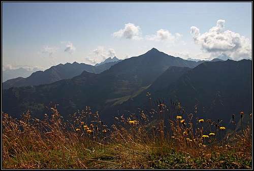
Hochspitz / Monte Vancomun from the west
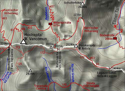
The map of the area

From the east

A big sheep herd
As it was mentioned on the sister pages of Hochspitz / M. Vancomun, on the pages of Baerenbadegg / Croda Negra and Reiterkarspitz / Monte Cecido, all mountains in the main Carnic Alps crest between Porze / Cima Palombino on the west and Torkarspitz / Monte Pietra Bianca on the east are made of older, paleozoic rocks. The latter two mountains are made of limestone. So the whole ridge is mostly easilly passable, still some sections are steep and rugged. Among all elevations in this section Hochspitz / Monte Vancomun is far the highest - a nice, sharp cone, which guarantees broad views on all sides.
Hochspitz / Monte Vancomun is rising between the high saddles Hochspitzsenke / Forcella Val Carnia, 2314 m, on the west and Forcella Vancomun, 2392 m, on the east. Towards the north the mountain is sending a strong ridge, which beyond the notch 2292 m rises again in the summit of Stollen, 2326 m, and then continuing northwards on Rauchbichl, 2180 m, and further on. This ridge is separating the valleys Winkler Tal and Raabtal. Towards the south also a short ridge goes, before lowering significantly down in Val Visdende (specifically into the side valley Val Antola) it rises on a fore summit, 2431 m. The nearby summits towards the west were mentioned on the page of Reiterkarspitz / Monte Cecido, so let's say only a few words about the summits towards the east. A rugged, rocky ridge first rises on point 2457 m, then lowers on Wallisches Kar / Forcella Val Grande, 2401 m, after which it rises again to the summit of Steinkarspitz / Monte Antola, 2524 m. This one is quite an independent mountain, but a humble one, so for now it will stay without its own SP page. From it towards the north a strong ridge goes on Schulterhoehe, 2424 m, dividing Raabtal and Ebner Tal, and towards the E-SE the main Carnic Alps ridge continues. It is still steep and rocky, abysses are on both sides, finally it ends on the broad, important saddle: Luggauer Sattel / Sella di Luggau, 2404 m. There a different mountain world begins.
As it was the case far towards the west, along the whole ridge on the southern side Strada delle Malghe (I think that in this area it's not a mountain road any more, but a path) runs, connecting alpine pastures. In the vicinity of Hochspitz / Monte Vancomun these are Casera Manzon on the SW, Casera de la Drotele on the S-SW, Casera Chiastelin on the S-SE and Casera Antola (the upper, and the lower one) on the SE. They all lie on the altitude of around 1900 meters. In this part Strada delle Malghe is identical with the Italian Carnic Alps long distance hiking route Traversata Carnica.
The Austrian Carnic Alps long distance hiking route, named Karnischer Hoehenweg, runs north of the main ridge. But mostly by the ridge runs the marked path No. 172, which is today treated as the etappe of the long distance hike. It is very panoramic, often visited and approaches also the summit of Hochspitz / Monte Vancomun. So, what people normally do - they sleep in the 4 hours remote Porze Huette, 1942 m, and in the morning start hiking towards the east. Or, they sleep in the 4 hours remote Hochweißstein Haus, 1868 m, and hike towards the west. Another long-distance route going by this ridge (the same path as No. 172) is Via Alpina, which crosses the whole European Alps.
Summit Views

Towards the SE

Towards the W
No need to stress that along the whole Carnic main ridge the views on all sides are exceptionnal. Along the ridge itself there are either kulisses of mountains following one after another, either diverse mountains, like the nearby limestone mountains and groups such as: Monte Peralba / Hochweißstein, Crode dei Longerin and Rinaldo group. Towards the north there are the nearby lower ridges of Lienz Dolomites, behind which the glaciated high peaks of Hohe Tauern are rising.

Monte Rinaldo group |

Monte Peralba / Hochweißstein |
Getting There
See the main area pages of Carnic Alps how to get into Lesach Tal (this is the upper valley of river Gail/Zilja) where the northern approaches start and into Val Visdende where the southern approaches start.
The northern trailheads from the Lesachtal side valleys are the following:
- In Winkler Tal. You can drive from Untertilliach or Bergen till the altitude of 1550 m, where the parking place is.
- In Raabtal. You drive from Untertilliach till the altitude of some 1500 m, where the parking place is.
- In Ebner Tal. From Maria Luggau towards the south (I don't have information where the road is closed).
- In Frohn Tal. From St. Lorenzen you drive southwards till the altitude of cca 1600 m, where the road is closed for public traffic.
The southern trailheads start in Val Visdende. By the valleys of Piave river and Cordevole creek drive into Val Visdende and till the eastern end of the road on 1332 m (Da Plenta hut).
Routes on Hochspitz / Monte Vancomun

On the E approach

On the W approach
1. From Winkler Tal. From the parking place, 1550 m, you proceed southwards, hit the Karnischer Hoehenweg and follow it left to the saddle of Hochspitzsenke / Forcella Val Carnia, 2314 m. From there you can go either left and then by the north ridge, or right by the Italian side and the south ridge on top. 3 h, medium hard walk-up.
2. From Raabtal. From the parking place, cca 1500 m, you go southwards to Mitterkarhuette, 1973 m, and then by Karnischer Hoehenweg towards the west on the north ridge and by it on top. 3 h (from Untertilliach 5 h), medium hard hike-up.
3. From Ebner Tal. This approach is already much longer. If you want to keep to marked paths you must first ascend Lugauer Sattel / Sella di Luggau, 2404 m, and then go by the main ridge over Steinkarspitz / Monte Antola, down by the southern side of the ridge (allways route No. 172) and then on top.
4. From Frohn Tal. This route is usually done as a daily etappe of Karnischer Hoehenweg / Traversata Carnica. So people use to sleep in Hochweißstein Haus, 1868 m (45 min from the parking place), and then go eastwards. From the hut 4 h to 4 h 30 min on top, medium hard hike up.
5. From the west. The western etappe of Karnischer Hoehenweg / Traversata Carnica starts at Porze Huette, 1942 m (45 min from the parking place). By the ridge route No. 172 you have some 4 h 30 min to the summit of Hochspitz / Monte Vancomun. A medium hard walk up. See also the pages of Baerenbadegg / Croda Negra and Reiterkarspitz / Monte Cecido!
6. From Val Visdende. From the parking place, 1332 m, you hike northwards on Casera de le Drotele and further by the path No. 128 and 172 on top. 4 h, medium hard walk up.
A remark. On my Tabacco map (it can be outdated) the path from Hochspitzsenke / Forcella Val Carnia, 2314 m, on top is not drawn correctly. It does not descend some 50 meters only later to go up on the south ridge. The new route starts ascending immediately from the saddle. First it crosses the slopes towards the SE, then in turns goes directly up the W face. A few passages are secured by steel cables, a few passages are narrow and not secured, but with some care the path is not too hard for an average hiker (and much shorter). After reaching the S ridge, the main path No. 172 crosses the grassy slopes towards the east and thus avoids the summit of Hochspitz / Monte Vancomun. Yet, a less beaten, but good path deters left and follows the S ridge. It approaches the summit from the left, first the lower NW summit with the cross and then the main, SE grassy dome.
In the near future I will post a short description of the whole daily etappe, which crosses also Hochspitz / Monte Vancomun.
Maps. Tabacco No. 01: Sappada - S. Stefano - Forni Avoltri. 1:25.000
Mountain Huts
- Porze Huette, 1942 m. Reachable in 45 minutes from the parking place in Obertilliacher Tal. 60 beds, opened from mid June till end September. Telefon (hut): +43/664/4038929. Telefon (valley):+43/4847/5243. Mobile: +43/664/4038929. E-mail: sport.auer@aon.at.
- Hochweißstein Haus, 1868 m. Reachable in 45 minutes from the parking place in Frohn Tal. 16+40 beds, opened from mid June till end September. Telefon: +43(4716)551, +43(0)6767462886. E-mail: hwh@aon.at.
- Boedenhuette, 2070 m. At the end of Ebner Tal.
- Mitterkarhuette, 1973 m. It's a bivouac-type hut, 4 beds. Accessible through Raabtal (valley in 1 hour 15 minutes walk).
When to Climb?
Hochspitz / Monte Vancomun can be ascended any time of the season. The ascent in winter conditions can be hard from all sides, except from the south. On all routes there are steep, rocky sections which are not hard in summer (because of well beaten paths), but in winter they can turn into hard sections (seen with the eyes of an ordinary hiker), requiring a full winter equipment (ice pick and crampons). Also the roads are not cleaned in winter, so the hikes are much longer. Otherwise the tours are in summer in the range of medium hard hikes. There are exposed passages, but paths are broad enough or well protected.