|
|
Mountain/Rock |
|---|---|
|
|
36.52158°N / 50.91542°E |
|
|
Mountaineering |
|
|
Summer |
|
|
11778 ft / 3590 m |
|
|
Overview
Click for Introduction to Central Alborz Mountains.Click to see the Map of the Takhte Soleyman Massif.
 East Face, Photo by FereidounForghani/Amirkhani
 Northeast Face
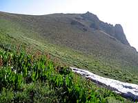 Southern Slopes
Dakooh Rises on the northern fringes of the Takhte Soleyman Massif. It sits in an area that marks the boundary between the high 4000 m peaks of the massif to the south and the lower forested peaks to the north that are close to the Caspian Sea.
To the north, Dakooh is connected to the northern-most peak of the Takhte Soleyman Massif: the 3221 m Shah Rashid Peak. To the south, Dakooh is connected to the 3640 m Reka Poshteh Peak.
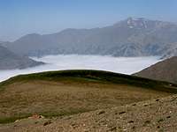
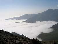
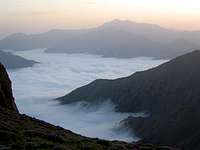
The western slopes of Dakooh are very steep and drop 2200 vertical meters to the bottom of the Sehezar River Valley. Its eastern slopes are gentler but also drop 2200 vertical meters to reach the Eza Rood River Valley. Both of these valleys head north and drain into the Caspian Sea which is only 27.5 Km away from the summit of Dakooh. Caspian Forests cover the valleys up to an elevation of 2300 m and clouds generated by Caspian Sea moisture often fill the valleys.
Dakooh is very far from the main peaks of the Takhte Soleyman Massif. It is usually climbed by those who like to explore the peaks of the northern arm of the Takhte Soleyman Massif. This arm consists of a ridgeline that starts at the summit of the 4430 m Ghobi Peak, heads north, slowly descending and giving rise to several major peaks as below:
 Sehezar Valley
1) Ghobi 4430 m
2) Looy Na 4340 m
3) Mazi Gardan 4140 m
4) Shoor Gardan 3953 m
5) Reka Poshteh 3640 m
6) Dakooh 3590 m
7) Peak 3483 m
8) Shah Rashid 3221 m
Dakooh can be accessed from the north via the seasonal village of Kia Neshinan. Most climbers, however, reach Dakooh via the summit of Reka Poshteh Peak (and ultimately Ghobi Peak) to the south (see “Route” below). The starting point for the hike is the village of Roodbarak to the southeast. From the summit of Dakooh, you can continue north to the seasonal village of Kia Neshinan (2400 m). You will then descend into the Caspian Forests until you reach some of the remote nameless logging roads and find your way to the coastal plain.
 South Face
Route:
The starting point for this route is the summit of Reka Poshteh Peak. Click here to see the page for Reka Poshteh Peak.
From the summit of Reka Poshteh, head north down easy slopes, toward a 3450 m Saddle between Reka Poshteh and Dakooh. Just before reaching the saddle you will come across a rocky formation. The formation can be passed by going through the notch between the two horns of it (see pictures below). This will require minimal hand and foot climbing and will expose you to slippery scree slopes for a short distance.
 Rocky Formation Rocky Formation |  Rocky Formation Rocky Formation |
After the formation, continue down easy slopes to the 3450 m saddle and then up the easy southern slopes of Dakooh to reach its summit.
Distance from the summit of Reka Poshteh is 1.5 Km (Total hiking distance from the village of Roodbarak is 24.6 Km).
To continue north to the seasonal village of Kia Neshinan, hike down the easy northern slopes of Dakooh, past Peak 3483 m (bypass it to the west of it). Before reaching the saddle with the Shah Rashid Peak, veer right (east) and gain the top of a very broad and slowly descending ridgeline that heads northeast (see picture). Follow this ridgeline on the south side of it until at 2700 m you reach a Shepherd House (Goosfandsara). From there you can follow a trail to reach Kia Neshinan (2400 m)
Distance from Da Kooh to Kia Neshinan is 8.0 Km.
From Kia Neshinan, you will hike another 4 Km in the forest to reach a nameless logging road where with some luck you might find a ride to the coastal town of Tonkabon. Be ware that finding your way in the dense foggy forest can be quite difficult. We happened to come across a man in Kia Neshinan who guided us to the mentioned road.
Below the Clouds:
Caspian Forests cover the slopes up to an elevation of 2300 m.
 | 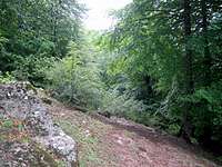 |  |
 Beginning of Forest Beginning of Forest |  Just above the Forest Just above the Forest | 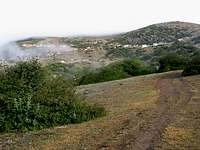 Kia Neshinan Village Kia Neshinan Village |
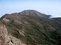
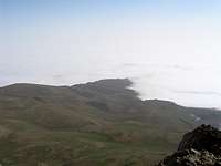
Views From the Summit of Dakooh: