|
|
Mountain/Rock |
|---|---|
|
|
36.45113°N / 50.93135°E |
|
|
Mountaineering |
|
|
Summer |
|
|
14239 ft / 4340 m |
|
|
Overview
Click for Introduction to Central Alborz Mountains.Click to see the Map of the Takhte Soleyman Massif.
Important note about name and elevation: Looy Na sits in a remote part of the Takhte Soleyman Massif. Neither the Iranian nor the Soviet 1:50 000 Map show the topography of this area very accurately. The name Looy Na (Kalchal) appears on “The Guide Map of Takht-e-Soleiman & Alam Kuh Region” (which is not a topographic map, but a schematic cartoon-like map). The 4340 m elevation is per my own GPS measurement. I am not aware of any other source that provides any information about this peak.
 North Face, Photo by fereidounforghani/Amirkhani
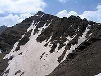 Summit
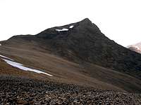 Summit
Only 33 Km (20.5 miles) away from the Caspian Sea, 4365 m (14321 ft) m above it (Caspian Sea, which is not a “sea” but the largest lake in the world, is 25 m below sea level).
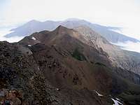
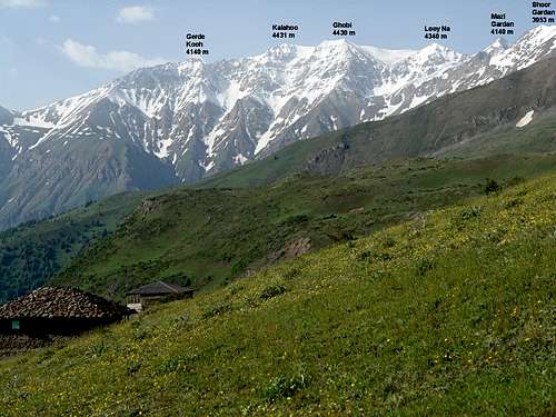
Looy Na is one of the northern peaks of the Takhte Soleyman Massif. To the southeast, it is connected to the 4430 m Ghobi Peak and to the north it connects to the 4140 m Mazi Gardan Peak.
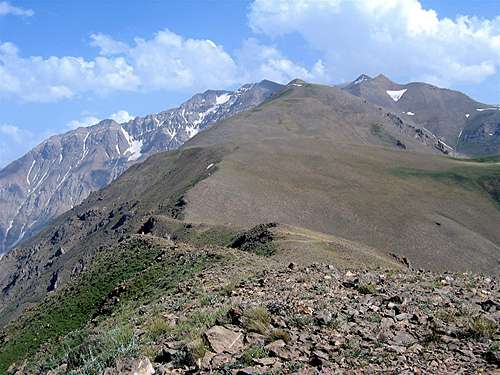 Looy Na is the second peak from the right
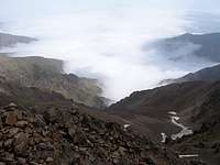
The western slopes of Looy Na are very steep and drop 2500 vertical meters to the bottom of the Sehezar River Valley and its northeastern slopes go down just as much to reach the bottom of the Eza Rood River Valley. Only 30 Km further north, these rivers drain into the Caspian Sea. Clouds from the Caspian Sea often fill the valleys to the east and west of Looy Na. These valleys are covered by Caspian rain forests up to an elevation of 2300 m.
 Looy Na is the third peak from the right
Looy Na is best accessed via the summit of Ghobi Peak (this requires at least a 2, if not 3 day trip). To descend into the Caspian Forests, from the summit of Looy Na, you will have to follow a ridgeline north. This ridgeline gives rise to 6 major peaks that can be climbed as an added bonus (see footnote below for the names of these peaks). After a 20 Km hike from the summit of Ghobi you will reach the seasonal village of Kia Neshinan (2400 m) which sits just above the edge of the forest. This village is inhabited only in summer (when we reached the village on June 22, there were only 3 young men in it).
To reach a road to take you to the Caspian coast, from Kia Neshinan, you will have to hike down through the forest to another village named Gaznachal (1900 m). After Kia Neshinan, we became hopelessly lost in the dense fog and the crisscrossing network of trails/semi-trails and in the end had to ask a young man from Kia Neshinan to guide us one hour (4 Km) through the forest to take us to a nearby logging road (2000 m) where we were lucky to catch a ride (2.5 hrs through the dense forest) to reach the coastal town of Tonkabon.
 Kia Neshinan Village Kia Neshinan Village |  Caspian Forests Caspian Forests |  Into the Forest Into the Forest |
Footnote:
Names and links (to be made) for the peaks on the mentioned ridgeline (south to north): 1) Looy Na 4340 m, 2) Mazi Gardan 4140 m, 3) Shoor Gardan 3953 m, 4) Reka Poshteh 3640 m, 5) Dakooh 3590 m and 6) Peak 3483 m.
Route Information:
Click below to see the route information for the Ghobi Peak (via Kalahoo Peak).
From the summit of Ghobi, head west and go down to reach a 4350 high point known as Siah Ghar, then turn north and follow the ridge-top down and the up again to reach the summit of Looy Na. Hiking distance from Ghobi is 1.5 Km.
Views from the summit of Looy Na: