4:30 a.m., July 1, 2008 – The Chimneys on the Northeast Ridge (Cooper Spur) of Mount Hood. +/- 10,000 feet elevation
Chris Wright - our climbing guide from Timberline Mountain Guides - was climbing with alacrity for the first belayed pitch of our effort. The rockbands signified where the real climbing began. Mike Dietrich (Chevy Chase, MD) and I rested as the rope paid out above our anchor. I looked out over the skies in the Columbia River Gorge, anticipating a dawn of bluish-pink cast to begin showing itself. Instead, I registered a lightening charcoal gray hue signaling something different.
“Well, that doesn’t look right,” I said to Mike as I scanned the skies east for changes farther up the Gorge. Up to this point we climbed in beautiful, clear night skies. The only problem was that it was too warm. The freezing level was 16,000 feet – way above Hood’s 11,239 foot summit. The ridge snow provided a nice air-conditioning effect as we ascended from our camp. Still, it was much warmer than I was used to climbing in the past. I was doing great in a base-layer, shell pants, and a wind jacket.
Chris gave us the signal to start climbing. I pulled up the “T” picket anchor, and we both climbed in tandem to save time. In a few minutes we reached Chris. We handed over the anchor. He verbalized my feelings about the weather conditions and finished by saying “The fastest way off this mountain is up and over.” Then up Chris went, into the increasingly sloppy 50 degree slope snow surface.
The Day Before the Climb, 8:30 a.m., June 30, 2008 – Forest Service Road 3512 below Cloud Cap Inn and Tilly Jane Campground , 4,900 feet elevation.
The drive from our link-up at Timberline Lodge was just enough time to get acquainted with each other. Mike and I happened to be the same age. Just like me, his wife and children were along for the ride to Oregon, but were entertaining themselves elsewhere. My wife, Alex, was with the kids (Christopher, 4 and Amelia, 7) heading to Hood River Railroad with my father and stepmother.
Mike Dietrich, a telecommunication executive from the D.C. area, successfully climbed Aconcagua and had some experience trekking in the Karakorum. His reasons for climbing reflected my own. It didn’t take long for me to like Mike. He was a man “haunted” by the high peaks of the world. Like me, he languished in an area of the continent not known for possessing an abundance of alpine terrain. We seemed to have both signed up to climb Mt. Hood’s Sunshine Route as a parole from our prison sentence in the lowlands.
Four years prior, I completed the Basic Climbing and Crevasse Rescue Course with Timberline Mountain Guides. Based out of Bend OR, TMG proved to be a good match for me. Their guiding and teaching philosophy stood out from the "just enough to get the huddled masses up a glaciated volcano and back" regimen practiced by many services. With TMG, if you paid attention, you picked up on the techniques that went beyond self-arrest familiarization. In less than a day their guides taught me how to tie more complex knots than anything I learned in four years of Boy Scouts.
My Cascade mountaineering adventures were interrupted by a deployment to Northern Iraq. Redeployment from Iraq was followed by a family move to Fort Polk, LA. Although the intervening three years in Louisiana were enjoyable, I yearned to kick snow in the Cascades again. My summer leave was coming up and I convinced my wife that a trip back to Oregon would be good for the soul. Although she was initially skeptical, Alex finally agreed to the plan. We rented a cabin with my father and step-mother in Government Camp, OR. That would be the family's base of operations while I took part in TMG's Mt. Hood "Northside" program.
As Chris drove us along winding roads leading to the Cooper Spur turn-off he discussed his experiences as a climber and the fact that he just came off the North Sister a couple of days prior. Born in England but raised in Pennsylvania, our guide proclaimed his preference to rock over snow. Despite this, however, he was looking forward to climbing the Sunshine Route for the first time.
The ride up to Cloud Cap Inn was looking good for the first few miles. The Forest Service began clearing the road of fallen trees. Just the week before TMG did a recon of the road and did not make it very far. The Forest Service came in right behind them and cleared a good ways up; but the effort stopped well short of Cloud Cap and Tilly Jane Campground. A fallen tree halted our drive on the primitive road. Chris parked his Subaru and we unloaded for a hike. Within a few hundred yards of our disembarking we would find out why the Forest Service stopped clearing. Deep snowbanks from late season snows covered sections of road. Clearing trees through these banks would only have invited disaster for motorists trying their luck.
A telephone line cut offered us a way to walk up through the remaining switchbacks. Chris led us up to where the lanes began to disintegrate. After a couple of hours of alternating between the cutoffs and switchbacks, we arrived at the Tilly Jane/Cloud Cap intersection. The three of us followed what looked like an old ski-lift line up a short distance to the Cloud Cap Inn. It was 11:15 a.m. There at the Cooper Spur trailhead we found our last opportunity to use a pit toilet and refuel. The weather was beautiful and warm. Things were looking good. We started out on the trail-proper at 11:45a.m.
The shade of the tree-line kept the initial part of the trail snow-covered. Once we started breaking into the transitional scrub the snows cleared up and gave way to the rock and pumice of the Cooper Spur moraine. Only a slight haze diminished the imposing view of the north side of Hood as we approached. After a little under an hour of steady hiking we dropped from the spur onto the lower aspects of the Eliot Glacier. Chris’s plan was to cross the glacier and ascend to the base of the snowdome portion (vicinity the Langille Crags) of the Sunshine Route. There we would camp and prepare for the summit bid.
We kicked snow for an hour. About 200 feet below the Eliot Glacier Icefalls we stopped at a rockpile to break and assess the weather. Chris was rightfully concerned about the conditions. Early in the evening the day before, a major squall rapidly ensconced the mountain with lightning strikes starting a fire near a ski area. A repeat of that event while we bivouacked on a high glacier wouldn’t be good. Forecasts indicated an increased chance for storm activity that afternoon. As he waited for a cell phone weather update from the TMG office, Chris mulled over the contingencies. After he discussed his concerns with us, he made the decision to retreat from our gains and move down closer to the tree-line back on the spur. We would start a few extra hours early tomorrow for the effort. Mike and I were disappointed but understood the decision.
The three of us descended back to our entry point onto the glacier and began backtracking to the tree-line. Chris took us off the trail and towards the west side of the spur and as we walked he briefly mentioned the Cooper Spur route option. At that mentioning, I looked to my right and up the Northeast Ridge of the Cooper Spur route.
“I like that option…a lot,” I said to Chris with Mike in earshot. I mulled over the fact that we were moving closer to its line and it offered a more rapid ascent from a lower (thus safer) jump off point. If it came to a vote, I knew what my decision would be.
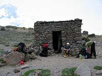
After twenty minutes or so of walking across the moraine, we arrived at the stone shelter. Chris never used it before, but knew it was available for our use. We were the only group on the north side of Hood, so there were no concerns regarding sharing the site.
3:30 p.m., June 30, 2008 – The stone shelter on the Cooper Spur Trail (Trail 600B), 6,700 feet elevation.
![Unwinding at the stone shelter]()
It was a low “high camp”, but it gave us easy access to the most direct route to the summit known on Mount Hood. Chris stated that we would wait here and possibly move back up to regain our losses and move up to the snowdome camp above the Langille Crags. He registered my inclinations, but still kept the Sunshine Route as his primary option. I told him I am not married to any particular route as long as we were making a go of it. At this point Mike was mulling over the options as well. From our vantage point, the Northeast Ridge was a more imposing line. He stated that he never climbed anything like that despite his experiences in the Andes and Karakorum. I looked over to the Sunshine Route and noticed the bergschrund below Horseshoe Rock was wide and laterally stretched to the line of Cathedral Ridge. The only reasonable way around the ‘schrund was a narrow looking shelf of snow left and below Horseshoe Rock itself. Otherwise it was a long traverse to Cathedral Ridge for a final effort to the summit.
The only thing breaking the line to the summit via the Northeast Ridge was the upper rockbands known as The Chimneys; and I could trace the path through to the final slope. Both routes were feasible in my assessment. But the Cooper Spur-Northeast Ridge was the path of least resistance offering a speedier ascent and less exposure to weather changes. My mind was made up.
It seemed that Chris was thinking along those lines as well. He was making call about the possibilities back to the TMG office. Mike was still formulating his thoughts. As we snacked and took pictures while relaxing, he approached me and asked: “So…you think the Cooper Spur?” He looked for consensus on his reasoning. I paused before answering; understanding that my answer would probably send us down the path we would go.
“That’s my vote,” I replied quietly.
Within minutes the decision was made. Chris was melting snow with his stove and making trip calculations for the new route. Getting the go-ahead from the office, we made preparations for an 11:00 p.m. wake-up and midnight launch. Chris showed us how he was making the mathematical calculations for the timings. We then rehearsed the procedures for belayed pitches when the slope required protection. Falls from the Northeast Ridge were usually unstoppable, with only a few surviving down to the Eliot glacier. In this case a bergschrund “catch” under the North Face routes would be our resting place if the worst happened.
We ate dinner, filled our bottles, and spread out in the relatively cool atmosphere of the stone shelter. Chris settled down outside to monitor the weather. As the light slowly faded to twilight, I fidgeted in and out of sleep; finally dozing off after a couple of hours.
11 p.m., June 30, 2008 – The stone shelter on the Cooper Spur Trail (Trail 600B), 6,700 feet elevation. “Alpine Start”
I awoke to Chris cranking up his multi-fuel stove. He poked his head in the shelter and stated it was time to get moving for breakfast. Mike and I launched out of sacks and began preparing for the effort that would start an hour hence. Chris’s hospitality was marked by fresh French press coffee I gratefully accepted in my newly acquired silicon squishy mug. Two packages of instant oatmeal and I felt full and ready to go. One of my trekking poles was failing to collapse. It was never right after I repaired it during a Mt. Adams trip a few years prior. Not wanting to carry an antenna up the mountain when we switched to axes, I donated the single pole to anyone who came across it at the shelter.
It felt odd being warm at this time of night. I believe Mike was so used to donning layers in extreme environments that he put on too much clothing to suit me. Base layer, snowpants, socks, boots, head lamp stretched over my reversed sun hat; and that was it for me. I kept my wind jacket handy on the top of my pack when we reached the cooler temps higher up. One final check of equipment and off we went – midnight exactly.
1:30 a.m., July 1, 2008 – “Tie-In Rock”, end of the Cooper Spur Trail, 8,500 feet elevation.
Chris’s night navigation was dead-on. Our tracks lit by headlamp, we hiked for a little under 1.5 hours before we came to “Tie-In Rock”. The site is marked by a cairn adorned with a classic wooden shafted ice axe and vintage crampons. I remarked that this must be Tie-In Rock. Chris jokingly replied that we would not be tying in here. The three of us pressed on to the Northeast Ridge of Hood as the Cooper Spur moraine rapidly faded in the darkness behind us. The air was cooler as a slight breeze materialized. I managed to put on my wind jacket during a short halt. The snow was soft and showing signs of weakness as we progressed higher. Traveling without crampons and axes was proving to be no problem. As the slope increased to 35+ degrees I felt a little uneasy with just one trekking pole. I asked Chris if we could halt so I could employ my 70cm axe. He suggested an axe/pole combination that did seem to offer security as the slope slowly steepened.
Mike was growing concerned with the slope angle. In his own visual estimation from the day prior, I can assume he understood that the angle was only going to continue to increase. Since there was no crevasse hazard, I felt ok going as far as we could without roping up. We were getting sufficient purchase without crampons and were making excellent progress. The climbing was good and I was enjoying the feeling of freely ascending a steepening snow slope – concentrating on keeping pace and my primary points of protection.
I was concentrating maybe too much on my own progress, because the sound of rushing water above me seemed to appear out of nowhere. This was more than a trickling stream. It was more like the steady torrent of a waterfall on a salmon run. I half expected to look up and see bears smacking sockeye as they jumped up a small river. Chris was surprised as well. The upper slopes were melting at an alarming rate in the warm weather and we would find the snow quality only getting worse the higher we climbed. We climbed over a rock formation where the melt-water was emerging from the underbelly of the slope. The three of us took the opportunity to refill what little water we used at this point.
Chris decided that this was our point of roping up. We harnessed and roped up; then off we set up what now seemed to be 45 degree slopes. It was now around 4 a.m. The morning twilight was barely evident. Our effort was within an hour of The Chimneys. I lamented that we were moving too fast in the dark for us to have good photos of the climbing.
Everything was going extremely well. The snow was sloppy but still holding. We launched off and up to the upper rockbands of the line where the real climbing would begin.
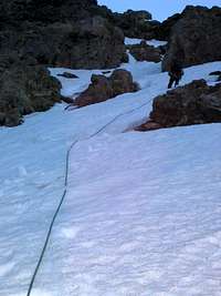
5 a.m., July 1, 2008 – The Chimneys on the Northeast Ridge (Cooper Spur) of Mount Hood. +/- 10,600 feet elevation
![Steep Snow and Rock]()
Into the third belayed pitch of climbing, the dawn sky revealed threatening clouds to our northeast. Chris’s climbing was obscured by the twists in the rockbands as we paid out the rope. Looking at my altimeter, I commented to Mike how close to the top we were. Over the past two pitches the snow was beginning to give us a hard time. Using my 50cm hammer and 70cm axe, both shafts would sink full length into cold soaking slush. It seemed that every third foot placement would give way under weight causing Mike and I to lose rhythm. It was a minor struggle to get back to Chris’s location. Once we made the pitch, we could tell that Chris was concerned about possibly losing the race with the weather. What he wasn’t telling us was that his gear was buzzing as we were now at the same level as the electrified system of weather energy. It was now an all-out sprint. We all tied-in close and moved together up the ever softening snow.
Our motivation was fueled by the rumbling sky behind us. Within minutes I was at maximum heart rate. It felt as if my chest was about to explode. There was no way to develop a rhythm as we wallowed in the slushy slop. Chris would kick steps for us to follow, but it didn’t matter. Every other foothold collapsed under my weight, sending me sliding back down slope. I would then sink waist deep into slush, having to claw my way out and up to the next collapsing step.
Had the situation been different, my cursing and spitting while struggling as the middle man on a short rope would have been comical. It was to the point where I had to gasp for Chris to give me more line to work with. I needed more rope to engage in the struggle without eating crampons above me and compromising the rope below me with my own footwork. Mike was doing his level best to climb fast and maintain an appropriate level of tension from him to me. My failing steps would cause undue slack in the line as he progressed in what little footing I established.
Chris knew we were losing the race and struggled mightily to keep us going. Even though he was lighter than me by forty pounds, he still wallowed under a heavier pack load. His steps failed almost as often as mine. The rumbling sky continued swirling behind us as we flailed our way up against deteriorating axe and foot placements. While we all struggled together, we were also locked in our own solitary fight to keep our bodies going against their will. I could only imagine Mike’s frustration in watching me slide down slope above him. As far as I could tell, he was holding it together better than I was. I was getting angrier and angrier at the situation.
Suddenly, out of the corner of my eye, I saw the inevitable lightning burst. Just the sight of the flash sent me into a streak of cursing. Everything seemed to blur as I focused on doubling an already maximum effort. Mike timed the thunder report and said it was about four miles away. By this time, our effort had brought us to the gentler slopes of the summit pitch. Our speed picked up as the slope slackened. It was now a dash to get over the summit and down the Old Chute.
6:30 a.m., July 1, 2008 – Summit of Mount Hood. 11,239 feet
There was no time for summit photos, no reveling in the accomplishment. We crested then began hoofing it across the small plateau to a small rock pile. As we began catching our breath, Chris calmly instructed us to ditch all metal objects at this point. Mike and I were a little caught off guard, but did as instructed. As a soldier, I understood the safety procedures during a lightning storm. After we dropped our axes, poles, pickets, and screws, the three of us dashed west to the Old Chute. Amazingly, with the peeling thunder behind us, we saw a group of three climbers making their way up the Chute.
“They must be insane!” I said. “Don’t they see what’s behind us?”
Chris commented that it never ceased to amaze him what he saw other climbing parties do. He set up a hasty sitting belay point and told us to abseil down facing up slope. We rappelled awkwardly down the Chute, barely able to keep footing as the rope pay out exceeded our ability to find balance. At one point my leg sank so deep into the snow that I almost snapped my leg in two when the combination of my pack weight and Mike’s downward effort pulled against the ligaments of me knee. Mike stopped and climbed back up to me while I began to dig my leg out of the snow. He helped me up and we resumed the abseil.
No doubt the sight of us rushing off the summit caused the three climbers moving up to us to pause. We informed them of what was going on up high. I told them they may want to consider holding fast or descending. Chris, who had made his way down by this time, was a little more direct in his advice to get off the mountain now. The team leader looked to the other two partners and started discussing what we told him. Not sticking around, we plunge-stepped down to Crater Rock over the Hogsback. We informed a few more groups on the way down and proceeded to limp down to Triangle Moraine, finally unroping and doffing our helmets. Chris was more relaxed now that the immediate threat was over.
I noticed from the south side of the mountain, things didn’t seem to be so threatening. It was easy to see how climbers wouldn’t really assume much was going on up at the summit or on the other side of the mountain. Chris informed us as we began the plodding descent to Timberline that his metal equipment was “buzzing” and that is why we dashed to ditch our metal gear. We knew that we had escaped a close one. The lower we got, the lighter our mood became. Our conversation turned to books we’d read or if our families would be at the Lodge so early considering how fast the climb went.
We arrived at Timberline Lodge at 9:30 a.m. Our carry-over from the stone shelter at 6,700 feet to the Timberline Lodge on the south side took us exactly 9.5 hours.
Closing Comments
As we wound down and regrouped in the Guide equipment room, I asked Chris how high he would rate our outing on the drama scale. “High” was his reply. We both agreed that the Cooper Spur route is a great climb. It would have been better if the snow conditions were better. But overall, this was a case of what Chris termed “second-order fun” or a climb that was fun after-the-fact. He only knew of one other effort on the Spur all season. As far as he knew – even with the bad snow conditions – we accomplished a fairly respectable traverse in a better-than-average time. After discussing how our gear would be retrieved from the summit, we all exchanged contact information and bid our farewells.
Drama and all, I view this climb as a worthwhile introduction to technical ridge climbing. The slope gave me the sense of “reverse exposure”, just the opposite of the exposure a climber feels as a slope decreases higher up. In this case, the slope increases and the climber can look down and see the path below; as opposed to the “pinnacle of the roller-coaster” effect in the reverse. As stated before, falls from the Cooper Spur route are often disastrous. Most falls I’ve heard of occurred on the descent of the Spur, and it’s easy to see why. Luckily, that was not part of our plan.
The Cooper Spur/Northeast Ridge route is categorized as “non-technical”. True enough, there were no technical difficulties. The climbing aspects were excellent, however, and it is easy to see why it is a relatively popular route. Having done this route, I would have a hard time climbing the South Side again. I appreciate the effort and professionalism of our guide and the all-too-brief partnership with Mike Dietrich. Mike made a better effort at taking photos during the action; many of which are included in this report. - Rob Ricks
July 14, 2008
Post Script: July 23, 2008
Mike and I received the equipment we left on the summit last week via USPS. No doubt, we'd have all felt better walking off the mountain with our axes. Chris's decision was made based off the "bad vibes" (pun intended) he was getting high on the northside of the mountain. It was the right decision.
After a discussion Chris had with some senior guides, we all concluded that the mountain "was giving us what it was giving us." Frankly, we got off easy compared to what Hood's done in the past. The circumstances we found ourselves in was not the result of poor decision making. It's very common to err on the side of caution only to have the mountain reveal a clear path to the summit as we retreat from the golden opportunity. Making decisions based on imperfect information is what makes mountaineering what it is and is the very essence of leadership.
We all saw a window of opportunity that started closing rapidly the higher we got. It went from exploiting a window of opportunity to clawing to get to a window of relative safety. "Drama" presents itself in many ways. For us it was a race against the devastating effects of nature. I can honestly say that physical fitness was the critical factor in getting us up and over to safety. We were all up to the task. If we hadn't of been, the results would have been different. I'm just glad I wasn't "that guy" that would cause our effort to be stranded on the wrong side of the window; purely because of a lack of fitness.
I want to thank all the SP'ers for their gracious comments and votes. I cherish the feedback. The friends I've made on SP keep me connected and helped me prepare for the trials we openly offer ourselves up for. I also want to recognize Pete, Steve, Carlos, Nick, Bob, Chris, and Tom from TMG for opening up a vast body of knowledge on alpine climbing.
Most important is the support of my father, my stepmother, my wife, and two children. I would not have been able to set foot in Oregon if it weren't for their willing participation.
Cheers!
RR
July 23, 2008


Comments
Post a Comment