Route Description
The whine of the gearbox in second gear marked the beginning of the spur road. In the darkness the encroaching plants and potholed road made the sense of anticipation that much greater. A glance at the clock: 2:45 A.M. Rattling along the gravel on the final road to the trail head, we stuffed ourselves with PB and J, water, and cornbread. The thin sliver of the moon shed little illumination as we dressed in the cool, crisp fall air. We hoisted our packs, surprisingly light for climbing packs, and began the long, slow walk through the forest. The trail in was in good condition, having been cleared at the beginning of the hiking season. Only the occasional stumble on protruding roots reminded us of the roughness of the trail.
![Glacier Approach]()
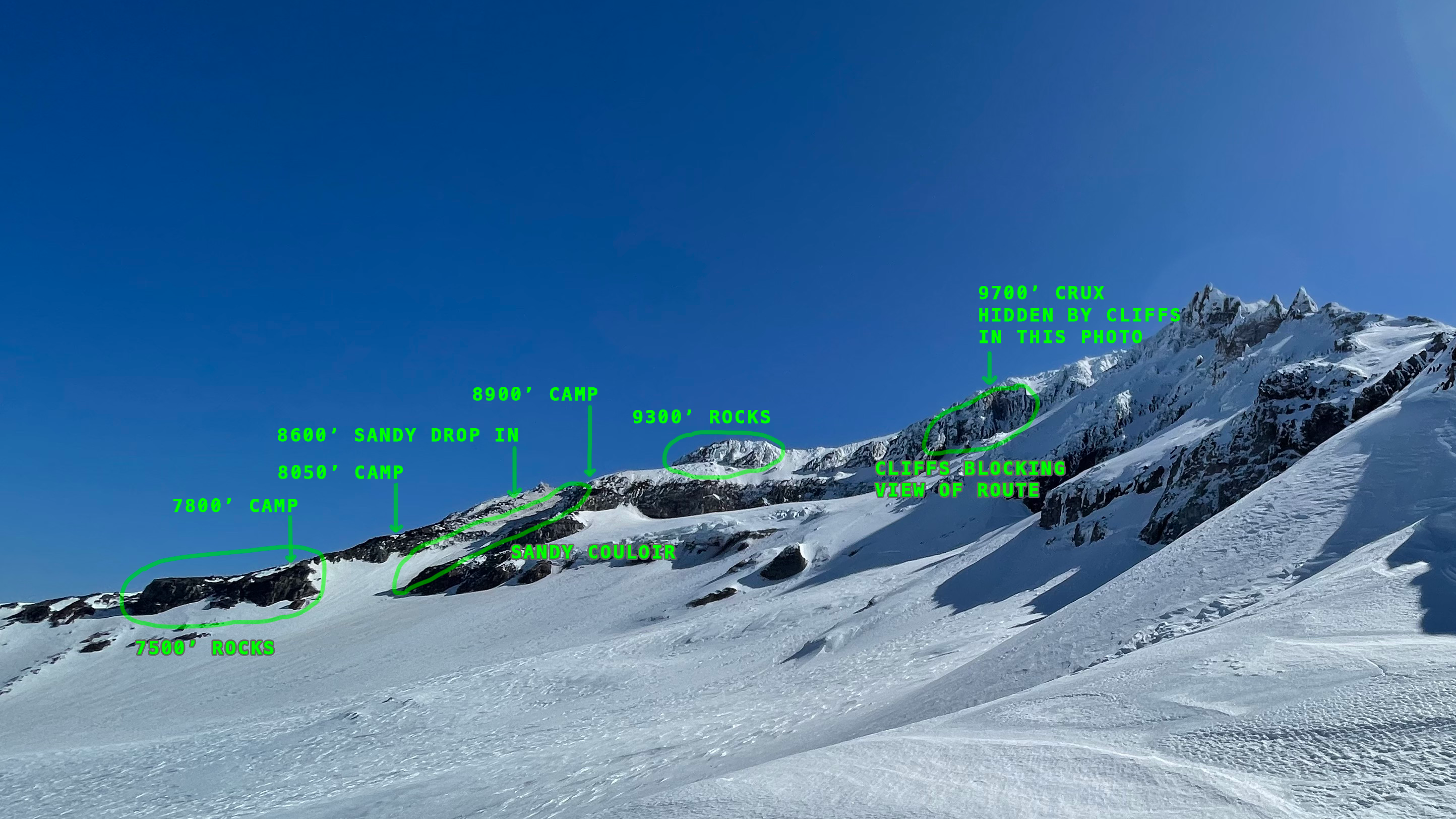
The entrance chute is just past the first line of snow which angles diagonally up and left, on the scree field below the first band of cliffs. Notice the vast volume of the glacier can be seen in this picture. Most of the moraine has ice underneath. Above the glacier, the Sandy Glacier Headwall rises to the junction of the two ridges. Yocum Ridge's 1st and 2nd gendarmes can be seen before the small flat midway up the ridge. Directly below that place, one can see the rarely climbed, 65 degree couloir, which is one of the steepest routes on the mountain. The 3rd gendarme on the skyline marks the end of Yocum Ridge.
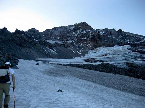
The sun had just risen when we reached the McNeil shelter, casting the Cathedral side of the mountain in a pale, bluish shadow. The ridge lines, those of Yocum, Cathedral, and the Summit stood starkly against the skyline. The snow from the previous weekend still rested on the slopes above. Following the hiking trail along the ridge, we finally left the heather and krumholtz behind. Where the first decently flat contour to the glacier appeared, a little ways above the waterfall to the right, we dropped from the edge of the ridge. Rock hopping on moraines is never very pleasant with a decent pack, and this was no exception. Soon though, we were on the satisfyingly solid freeze-thaw snow of the Sandy Glacier, enjoying the spray of snow with each kicked step. The imposing access chute appeared from behind a small sub-ridge.
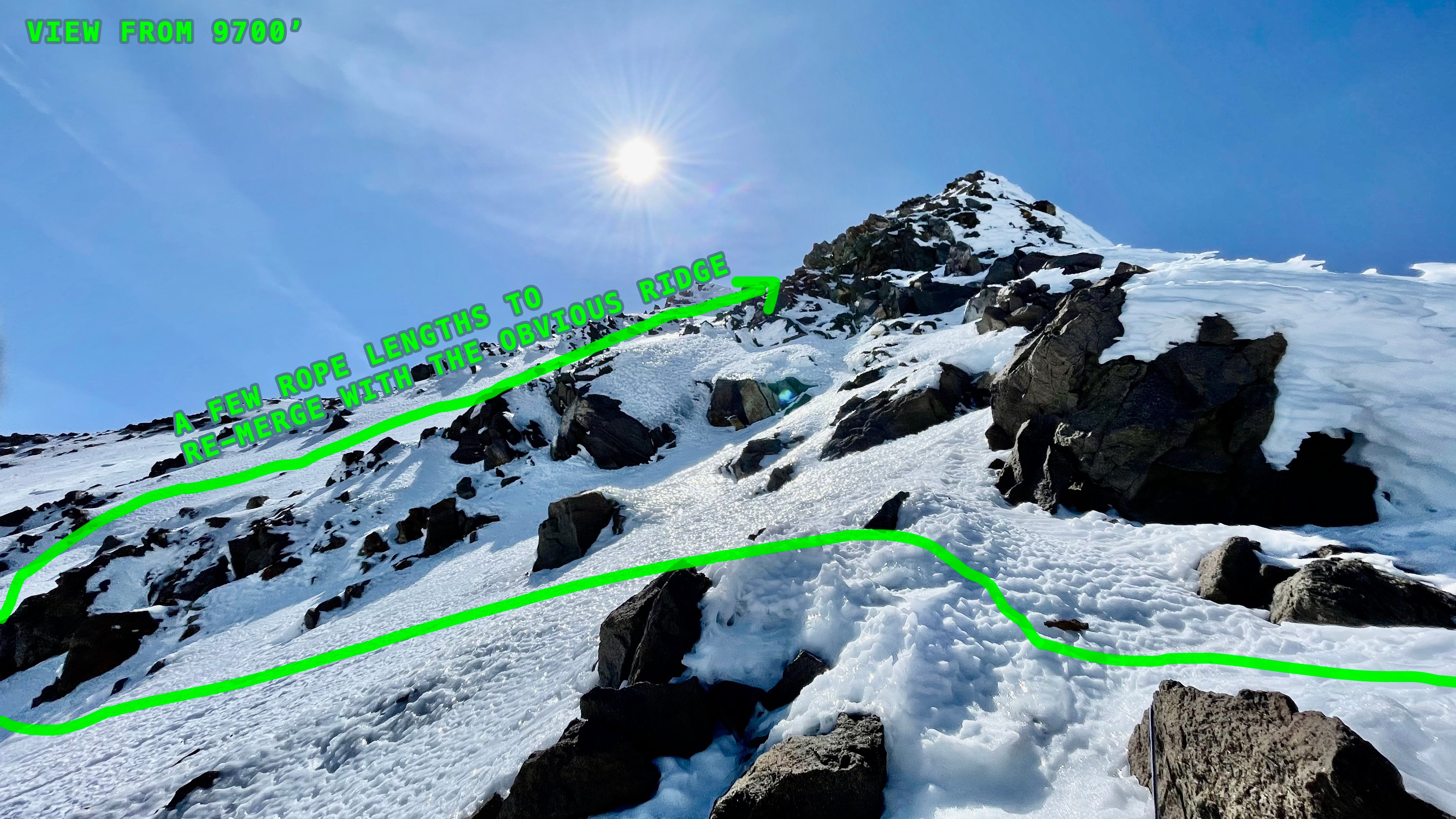
Main Ridge
The center of the chute looked, for lack of a better description, messy. Jumbled rocks, fallen from the gumdrop filled the center of the chute. The east side looked tenuous at best, showing a regular tendency of slabbing off. Recognizing the 1000 foot elevation gain from the bottom up, we made the wise decision to stay left, working our way up a set of third class stepped slabs, slippery with the dust blowing off exposed mud on the nearby ridges. The brittle cool of the morning soon turned to sweat as we made rapid progress up the west edge of the gully.
![Route]()
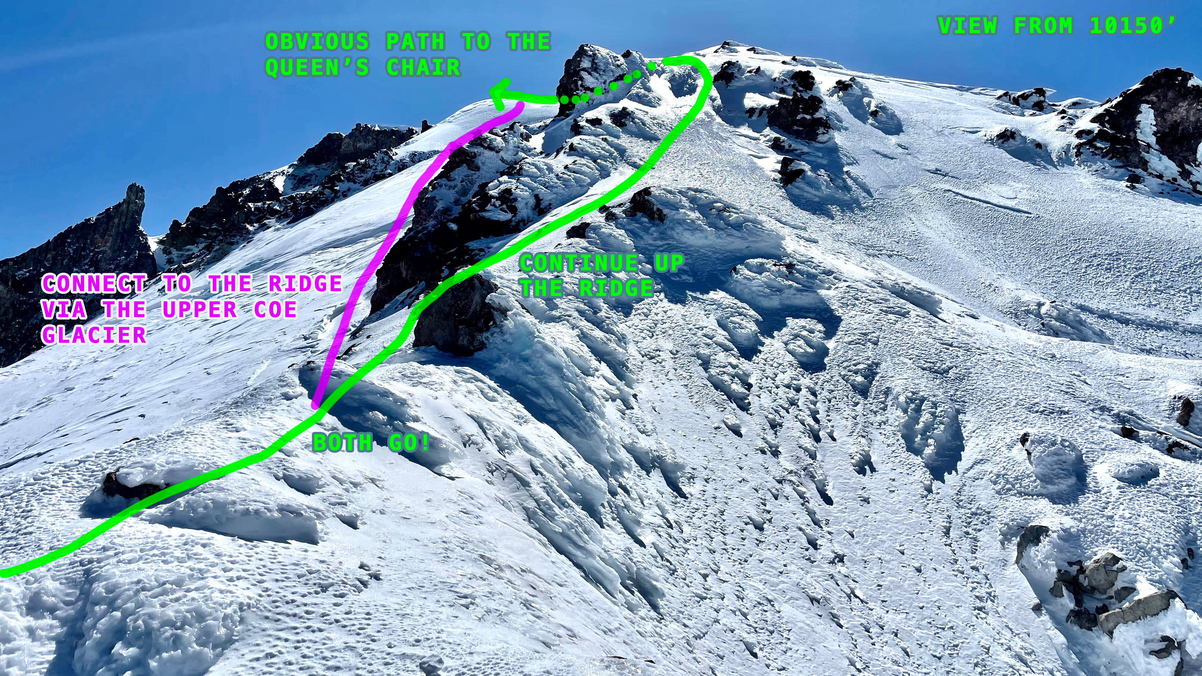
The route we took follows the green line. The "gumdrop" is the rock feature above the long horizontal traverse and the traverse above Barrett Spur is shown where the route line first disappears behind the ridge. The Queen's Chair, the last major landmark before the summit, is across from where Yokum Ridge intersects the main body of the mountain.
Three quarters of the way up, the chute splits-a fourth class step below the gumdrop on the right, or a straight shot to the ridge above. The gumdrop's rock looked like granular sugar, so we opted to hit the ridge. Forty minutes after starting, the expansive view of both sides of Cathedral greeted us. The crumbling fortress of the Pulpit hung to the edge on the right, Barrett Spur, with it's shark's fin profile, rose from the flat plain flowing out below, and the broad, forested ridge of Mt. Defiance dominated the view to the north. To the south, the partially snow covered, hanging glacier spanned the gradual contour of the mountain to Yokum Ridge's 60 degree ramparts.
The pleasant sun on the ridge crest spurred us on, in a horizontal traverse under the gumdrop. Loose scree over rocks below our feet, tons of rocks above, we picked our way carefully right. Clinging to the base of the gumdrop, avoiding the cliff below, we soon reached the "solid" rocks. The fractured remnants of the ridge, the rocks were poorly balanced and poorly adhered, resting just below the angle of repose. A badly defined arete in the rocks offered the safest route up. A chute to the right looked appetizing, but we were not willing to wager more than necessary that late in the season. Five minutes later, we had a three hundred pound reason to stay where we were. The rock came bounding down, making one hundred foot leaps, and disappeared over the cliff above the glacier. A posse of small rocks followed, like ducklings after their mother. Regaining the edge of the ridge, the view ahead was not promising. Climbing the ridge direct was beyond our skill level, the route to the right, a gamble with our lives, and the left traverse, an exposed one over the Ladd Glacier Headwall.
![Above Gumdrop]()
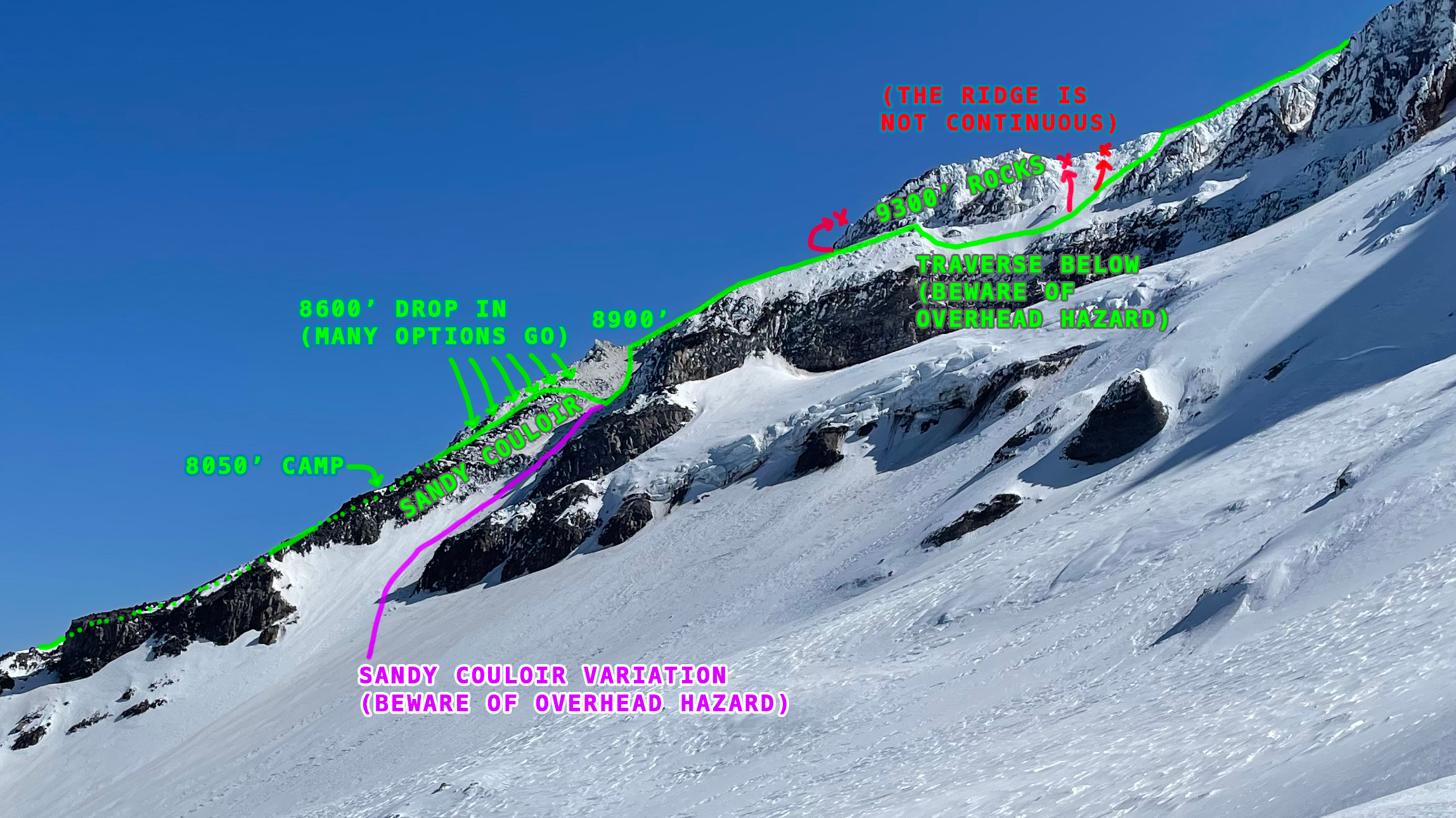
The route follows the vertical cliff just to the left of the shadow half way up the picture. It then basically follows the shadow line to the camera location. The traverse starts from the camera location.
The snowy remnants of the last weekends storm filled the runneled north side of the ridge, a glaze of snow over loose rocks. In other words, very slippery. Time for crampons. Stuffing the packs into one of the plentiful holes, we pulled them out, the heavy canvas toolbags crinkling as the steel slid past the velcro closures. Rigid climbing boots and step in crampons diminished the precious time; precious because the sun was rapidly warming the snow. We had to keep moving.
![Mid Ridge]()
This is the belay stance, actually on the way down, where the real climbing started. I am sitting wedged between two of the few solid rocks on the ridge. The angle can be clearly seen in the foreground with the gumdrop below and to the right. The McNeil Shelter can be seen if the picture is enlarged fully, a minuscule black dot just above treeline.
Sticking to the still frozen snow in the shadows, we made the most of the poor conditions. The angle averaged forty degrees, but had bulges to fifty degrees. By using ALL 60m of our rope and the available natural protection, we regained the ridge in two pitches. Straddling the narrow ridge top, the leader belayed while the other hustled, blowing hard, to the stance. Without the snow, the climbing would have been a desperate struggle posing a significant risk of freeze-melt and rope induced rockfall. Though the route has been climbed in the dead of August, snow free, the rewards of the climb a small compared to the risk. The climbing is not pleasant without something holding the rocks together. Fortunately for us, though, there was snow, and having passed the most prominent obstacle in our view, we were dismayed to see that the complex, often knife edge ridge, extended well into the distance. We were less than half way.
![Upper Traverse]()
This image shows the steep slots on the northern traverse under the main gendarme of the ridge, visible in the Route photo. The ascent was slightly diagonal for the first pitch, rather than straight up to avoid the cliffs of the main gendarme. There is an obvious chute about 100' laterally from the first belay position which runs vertically to a small notch in the ridge. It was our experience that this was the best route, both from the bottom, and later during the descent. The boot tracks can be seen hugging the rocks on the right side of the image, then proceeding diagonally towards the leader. The sun had just rounded the edge of the ridge when this picture was taken.
Following the crumbly rock, we picked our way up the ridge, rope never far out of hand. The strange burnt orange of the rock, unusual in color for mount hood, lent an eerie felling to the climb. The climbing was easier (third class) and the warmth of the sun pleasant for our bodies, if not our minds. Following the rapidly ascending ridge, we came up against the final obstacle: a mostly melted out, 50-55 degree bump in the ridge. It would have been easy had the snow been solid, but it was not, having rapidly turned to slush as the sun's morning rays struck it. With a few wide bridges to avoid the thinnest spots, we stood on top of the bulbous obstacle.
The new snow started to ball up on our crampons, ABS plates and all. Four steps, then foot up, the clink of an axe striking metal, and four more. Soon, to our relief, the new snow disappeared, leaving us with the hard, permanent snow the glacier. Moving quickly now up the gentle grade of the glacier, we made it to the Queen's Chair in the time it took to catch our breaths. Eating a quick meal of Gu, Shotblocks, and water, we ditched the heavy gear and one of the packs. No rope from here on out, but crampons until the snow and mud ended.
![Yokum Ridge]() Yocum Ridge's final crest is a multicolored knife edge of mud.
Yocum Ridge's final crest is a multicolored knife edge of mud.
Kicking the final steps up the snow, a more fluent, relaxed conversation developed; one not interfered with by large, loose boulders overhead and rapidly warming snow. Mid sentence, I stopped, awed by the view south. The sharks fin of the third gendarme of Yocum ridge rose from behind the edge of the ridge. The fact that it was standing amazed me. Its mud slopes vertical on one side, fifty degrees on the other. Rime ice that does stick in the winter must be so fragile and so honeycombed that the thought of climbing it is terrifying. It is not surprising that it took Fred Becky and Leo Scheiblehner until 1959 to climb the route, and even longer than that to climb it direct. To the left, the gradual roll off of Leuthold Couloir's upper bowl brought us face to face with the source of an avalanche that tumbled us 1100 vertical feet down the couloir, back through the Hourglass.
Climbing the previous spring, just above the hourglass on easy ground, the ground began to shake as a torrent of loose snow raced down upon us. Swept off our feet, we tumbled and bounced our way back down the debris fan at the base of Leuthold. By the time it stopped, we had not breathed for nearly a minute, our nostrils and lungs filled with powder. We made it out, but we could not figure out why, on a 21 degree day with only 4 inches new snow, the avalanche would be so large. When it came to a stop, it stretched from the bottom of the fan to the hourglass, a couple feet thick and 75-100 feet across.
Looking across the bowl, we found the answer. Erode mud bollards, six or seven feet tall would form decent sized cornices, which when released would trigger the entire center of the bowl. Remarking on our good fortune, we continued up, not without a few backward glances. We had been so close.
The last few steps to the top of the ridge were uneventful, a non technical, though tiring, hike to the summit ridge. Negotiating the ridge was more challenging that expected, being totally melted out. The brown dust of the slopes under our feet, the spire of the cleaver below, and the weathered appearance of the Elliot in fall made the traverse bizarre. Never before, and never since have I been on the summit of that mountain so late in the season. I am fairly certain that we were the only people to reach the summit that day. My father's sharp eyes picked out two skiers on the uppermost part of the Whitetip Glacier, moving slowly far below. It was a stunningly clear day, Jefferson to the south, Adams across the river, Helens and Rainer to the northwest, and far out beyond, the glaciers of the Olympic Range, a light showing through the cumulative haze of a few hundred miles. The watch said 11250, a little high, but not far off. It was 2:00 P.M. We had been on the move for 11 hours and 7000'. We recorded the summit with the same cheap point and shoot that took the previous over exposed pictures. The photos of us standing in disheveled clothing, a half tucked in green shirt, black tights, and half smile remind us of the exhaustion we were feeling. Now we had to get back down.
![Summit Record]() No excuse other than that it was a long day and I didn't care about much. | ![Repeat]() Thirty years apart, on the summit again via Cathedral Ridge. (Notice the Home Depot flag to the right). |
Descent
The sun was high in the sky, and had been for a while when we reached the summit. Knowing that the snow was progressively softening, we made tracks for the car. We crossed the summit ridge quickly, then half jogged down the relatively low angle bowl above Leuthold. The ground was just muddy enough to be slippery, but not unnerving. Legs burning, we arrived at the packs. The added weight disappointed; it had been such easy walking just before. Our only consolation was that the air grew increasingly thick the lower we went.
Working our way carefully down the whispering slush, we reached the first steep section, the bump from before. It looked steeper from above. I was first. Traversing back across the thin smear of snow tested my patience. The snow had been hard before, but now it held nothing. By bridging and working tenuous edges hidden just below the snow, I reached the bottom. (Why not rappel? Try to find a rock solid enough for an anchor is nearly impossible there. The solid rocks tend to be either far away from the steep sections or embedded in the sides of the ridge. Regardless, pulling a rope through volcanic dust destroys the rope quickly. Having just bought a new Mammut Infinity, we were not willing to do this unless absolutely necessary.)
Following without protection was worse of course. Climbers always say do not climb up anything you cannot get back down. Today being no exception, my father made the best of the situation, climbing with carefully weighted decisions until the ridge broadened. The dust mushroomed from under his feet as he made his way towards me as fast as I could pull in the rope. Walking together now to speed up the descent, we reached the last little step before the drop off the side of the ridge.


Comments
Post a Comment