
-
 30032 Hits
-
 88.19% Score
-
 26 Votes
|
|
Mountain/Rock |
|---|---|
|
|
45.91633°N / 7.86331°E |
|
|
14242 ft / 4341 m |
|
|
Overview
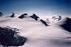
geographical classification: Western Alps > Pennine Alps > Monte Rosa Group > Ludwigshoehe
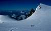
The Ludwigshoehe is only a "small" mountain compared to other peaks of the Monte Rosa. But it stands at a very important position:
- in political matter the italian regions of Valle d'Aosta and Piemonte meet with the Swiss Kanton Wallis.
- and with regard to topography: here the about 40 km long mountain range which separates the valleys of Sesia and Gressoney leaves from the main ridge of the alps. In this range there are the next 4000 m-peaks of Schwarzhorn/Corno Nero and Piramide Vincent and later on the Corno Bianco (3320 m). Further to the SE the range spreads wide and builts an area through which some parts of the GTA ("grande traversata delle Alpi") are a known mountain trail.
You will not climb the Ludwigshoehe for itself, but perhaps on collecting 4000 m-peaks on your way to or from the Signalkuppe, perhaps on the Traverse Vincent Piramide - Signalkuppe
Therefore you may also look at the Signalkuppe, at the Parrotspitze or at the Vincent Piramide
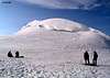
You may walk up to the summit
a) from NE from the plain between Ludwigshoehe and Parrotspitze (Piodejoch, 4283 m)
b) from NW from the Lisjoch respectively the place where the normal route from Capanna Gnifetti to the Signalkuppe/Punta Gnifetti crosses the italian-swiss border
c) from SW from the saddle which separates it from the Corno Nero (called Zurbriggenjoch, 4279 m)
It doesn't matter which way, it only takes some minutes and there should be no difficulty at all. Of course gear for glacier walks is necessary.
To reach the summit directly over the SE-side from the Valsesia (according to Dumler [Die Viertausender der Alpen, 3. Auflage 1978]: 600 m from the Piode-glacier, climbing IV-V, from the bivacco Capanna Fratelli Gugliermina/Valsesia (3312 m) would be a difficult climb.
The Ludwigshoehe has been climbed very early for the first time, August 25th 1822, and it got it's name from the first climber, Ludwig von Welden.
For more Overview Information, please read the Monte Rosa Page
 |  |  |  |  |
Red Tape
no limitationsWhen To Climb
March to May with ski, July to September on foot.Getting there and huts
As the Ludwigshoehe is near to the Signalkuppe, you can also refer to the Signalkuppe Pageor the Vincent Piramide Page
Starting point for the normal route from south is Alagna (1190 m) in the valley "Valle della Sesia".
a) You get there on the autoroute Nr. 26 about 30 km southwest of Lago Maggiore. (A friend of mine once drove into the wrong valley and lost a whole day)
b) You reach Alagna by car on the road no. E62 from Brig via Simplonpass. You turn off at Ornavasso (near the Lago Maggiore) and follow the small route to the S via Omegna. Here turn right and drive along the western side of the Lago d. Orta to Orgosésia. In Borgosésia you take the road to the N and reach Alagna via Varallo and Scopello.
c) You reach Borgosésia also from the S from Torino on the A4 till. Turn off with direction to the N to Gattinara and Borgosésia.
In addition to the Capanna Gnifetti (3611 m) there is the Rifugio Citta di Mantova (3498 m), 45 min below the Capanna Gnifetti. It is not so huge and a nicer place to stay.
You reach both huts from Punta Indren, 3260 m (cable car from Alagna), in 45 min Rif. Città di Mantova and in further 45 min Capanna Gnifetti.
If you are a real sportsman it's 7 h from Alagna (2420hm). In the lower part, it is a marked way (no. 5). The traverse of the glacier is not marked.
You reach Punta Indren on the marked hiking way no. 5 from Alagna via Dosso (1357m). You go to the Alpe Oltu (1847m, cable car station, 1,5 h) and further in the Valle d'Olen up. You go along the Sasso del Diavolo and reach almost Colle d'Olen, wher you turn right to the Vigevano-hut (3 h). You go further along Passo Salati (2936m) to the ridge-crest and traverse Stolemberg. Over the side of the Indrenglacier, you reach the station (1 1/4 h, totally 6 h)
From Punta Indren, you traverse the ski-run, slowly going up on the Indrenglacier till you reach the outstanding rock band above which the Mantova-hut is situated (yellow-red signs). You climb up the rock steps (fixed ropes). From the hut, you go up over the E-side of the Lysglacier to the N and at the end over rocks to the Gnifetti-hut.
You can reach the Gnifetti hut also from Gressoney in 6-7 h (1800hm). The lower part is a marked way (no. 6). Lift to Alpe Gabiet (1270 hm, 4,5 h). In the upper part: easy glacier walk.
update 2008:
the cablecar to Punta Indren from Alagna is closed since summer 2007. You can only reach Passo dei Salati (2936 m) either from Gressoney or from Alagna with mechanical help.
Maps and books
MAPSSchweizer Landeskarten, available at swisstopo
1:25000 no. 1348 Zermatt (best map, but it ends with the summit to the south)
1:50000 no. 294 Gressoney (shows the terrain on the italian side in swiss quality, but the content is not renewed since 1961. So for example the newer Mantova hut is not shown)
1:50000 no. 5006 Matterhorn-Mischabel (useful for a holiday in Zermatt)
1:50000 no. 284 Mischabel
italian map
1:25000 IGC Monte Rosa - Macugnaga - Gressoney, can be ordered at DAV Service
interaqctive swiss online map for Ludwigshoehe
BOOKS
Hermann Biner, Hochtouren im Wallis. Vom Trient zum Nufenenpass. 2nd ed. 1996.
ISBN 3-859022-160-5
Helmut Dumler/Willi P. Burkhardt, The High Mountains of the Alps. 1994. (to order at amazon.com)
ISBN 0898863783
Helmut Dumler/Willi P. Burkhardt, Viertausender der Alpen. 11th ed. Munich 1998.
ISBN 3-7633-7427-2
Michael Waeber, Walliser Alpen. DAV-Gebietsführer. 12th ed. Munich 1999.
ISBN 3-7633-2416-X
Michel Vaucher, Walliser Alpen. Die 100 schönsten Touren. 2nd ed. Munich 1990.
ISBN 3-7654-2124-3
The Alpine 4000m Peaks by the Classic Routes by Richard Goedeke, Menasha Ridge Pr; ISBN: 0897321111
 |
External Links
- Monte Rosa - 10 4000ers in 1 week!
- Ludwigshöhe at www.4000er.de
Images, routes, coordinates and more information about the highest peaks of the Alps