
|
|
Route |
|---|---|
|
|
44.13362°N / 113.76892°W |
|
|
Summer |
|
|
One to two days |
|
|
Class 4 |
|
|
III |
|
|
Overview
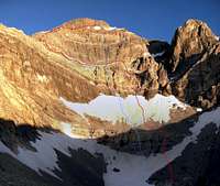
 The East Face Above Lake 10,204
 The Small lake above Lake 10204
Mount Borah is impressive when viewed from any side but the East face is downright striking. The last 2,000 + feet of which soar immediately over Lake 10,204’ and if the reflection is right the face appears to levitate.
A direct route up the face as far as I know, has only seen one serious attempt in 1978, When Bob Boyles and Mike Weber were turned back, first by large rock-fall and then heavy rain, omens that made them conclude, “We were not meant to be on this face”.
The Dirty Traverse climbs the lower section of the face, then crosses a steep shale covered ledge to the East Ridge and then rejoins the face for a final scramble to the summit. Although this isn’t the prettiest route on the mountain, in my opinion it’s the prettiest side to start from. The above photo shows the Dirty Traverse (red) and the East Face Direct (blue)
The Approach
 Pahsimeroi Valley TOPO.
Stop In Mackay or Challis and pick up a free Forest Service travel Map at the USFS. office or any convenience store.
From U.S. Hwy 93, 46 miles north of Arco (32 miles south
of Challis), follow FS Road 116 northeast over Double springs
Pass for 10 miles to the turnoff of FS Road 117. Look for the Horse Haven Pass sign. Follow 11 7 over Horse heaven Pass for 6 miles to the junction with FS Road 118. Follow 118 up the West Fork road for
4.5 miles to its junction with FS Road 267. Follow 267 for 2.5
miles up the West Fork Pahsimeroi River to the end of the
road.
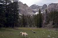 Meadows on the approach.
The approach is a moderate but very pretty 2.5-mile hike that gains just over 2,000 feet. From the end of the road, head due west; you’ll hike right between the creek and the makeshift toilet. Stay on the wide ridge keeping the creek to your left. The brush and trees are pretty sparse all the way up to the first big meadow at 9,000’ where you leave the ridge for more open country. From the meadow you get a good look at the upper face and the wild opening between the two east trending ridges that form the cirque. Continue up through rolling hills and timber to the lake at 9,800’ This is a seasonal lake that dries up in some years. From the lake you get a look at the final talus/boulder strewn 300’ obstacle to the upper cirque. At first glance, the top of this steep slope looks like a mere ledge at the bottom of the face but it opens up to a beautiful pocket cirque With a small lake and a Tarn that keeps water all year long. Start up the slope and leave the mosquitoes behind
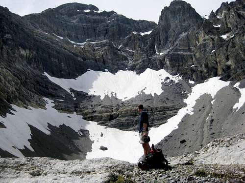 The East face from Camp at Lake 10,204'
Route Description
From the West end of the lake, hike up the talus and bypass the first cliff-band on it’s right. Gain the second snowfield and head for the obvious wave like formation on the lower face. From below, this may not look like the most obvious access to the face proper but the nature of the formation offers big holds and several different lines to pick from.The crevasse between the top of the snow and the face was several meters deep in places and the first few class 4 moves feel very exposed to the blackness below. The rock is surprising good for Borah but sharp as kittens’ teeth. Move up on good foot/hand holds for a couple hundred feet to the first big 45% shale covered ledge. The ledge presents perhaps the only access to the South East Ridge from the upper basin. The long traverse to the ridge requires precarious footwork along loose shale and steep snow but is easier than it looks from below at the lake.
The ledge joins the ridge at the bottom of a steep but climbable 50’ buttress. Climb over the buttress or bypass it on it’s west side and continue up easier but loose class 3 choss. I’ve always suspected the East Ridge dead-ends at the base of a 500’ class 5 headwall that makes up the summit block and as I climbed higher up the ridge, that suspicion grew. At the last few meters of the ridge however, a tiny col opens onto a 50% shale covered ledge and the upper snowfields. Eek your way out onto the ledge and cross the first small snowfield, continue on to the center of the next one and a class 4 chimney starts on the highest point of snow. After a few short moves, the climbing eases to class 3 scrambling all the way to the summit.
The Exit
From the summit, descend the standard South West Ridge route to the wide saddle at 11,800’ drop off the east side of the ridge and make your way down 1,200’ of steep chossy class three terrain. If it isn’t too soft, put your crampons on and descend the snow, especially if climbing with a partner as its impossible not to send rocks rolling. This is a long descent over tricky ground forcing you to pay close attention to your feet and the possible difficulties below. There are many opportunities to glissade but the run-out’s are pretty grim. The angle eases up at about 10,400’ making a further descent on snow the best option. Hike down to the highest tarn just below the 10,000’ contour line then start working your way back to the North East and around the East ridge of Borah. You’ll be tempted to skirt around the ridge higher up but it’s much easier to stay off the steep scree and hike to the wide saddle and then down to the “part time lake” you passed on your approach. From the lake, return to camp using the approach route. The descent follows the standard Borah route down about 1000' and then drops off the East side of the saddle.
Route photos
 Standing on the last of the snow slopes below the first wall
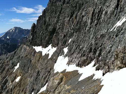 The Dirty Traverse ledge leading out to the East Ridge from the center of the face.
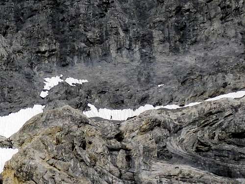 Crossing the Traverse ledge. Shot from camp.
 This is a view looks down on the traverse ledge from the East Ridge.
  The key to the climb. A tiny col opens up where the East Ridge meets the upper East face. this shows the small snow field one crosses to get to the summit.
Links
Lost River Ranger District
The Mount Borah Page
Mount Borah East Face Direct Route