
-
 15294 Hits
-
 95.01% Score
-
 50 Votes
|
|
Mountain/Rock |
|---|---|
|
|
40.41346°N / 111.65637°W |
|
|
Utah |
|
|
Scrambling |
|
|
Spring, Summer, Fall, Winter |
|
|
10509 ft / 3203 m |
|
|
Overview
Forgotten Peak is an obscure much less well known rugged summit located on the Mt. Timpanogos Massif. It received it's name from a well known local guidebook author, Michael R. Kelsey who has a self published book completely dedicated to Mt. Timpanogos. Forgotten Peak is one of the more technically challenging summits in the Timpanogos Group, similar in nature to the nearby Razorback Ridge area.Being less known on this popular mountain does not detract from some of it's features. Jagged broken limestone, steep approaches, and exposed scrambling all contribute to an interesting jaunt across this summit. It also features views of the surrounding peaks on the north side of the mountain which rival those of Robert's Horn located above Emerald Lake, just north east of the main summit of Mt. Timpanogos. North Timpanogos, and Bomber Peak are less the a mile away and views of these summits from the top of Forgotten Peak are top notch. The Giant Staircase also can be viewed from the summit as well. The upper reaches of Pica Cirque border this peak steeply below to the west.
 View south from the summit of Forgotten Peak.
 Goats on Bomber Peak's Summit near Forgotten Peak.
 Forgotten Peak from the Timp Glacier, May 20, 2010.
Other features this peak has going for it is the local mountain goats which frequent this less traveled area, and the abundance of fossils found on the saddle and ridge area. For those seeking some solitude on Timpanogos, this peak is definitely one to check out as most of the other human occupancy on the mountain are headed for the main summit of Mt. Timpanogos.
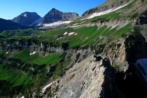
 View north from the summit of Forgotten Peak.
 Looking at North Timp via Forgotten Peak, almost 1,000 feet above.
 Looking at Bomber Peak from the summit.
Getting There
This peak is best reached from the Timponeke Trail. Fellow SP'er Dean has written up an excellent page on the trail. Getting to this trail head is copied from his page.To access Mt. Timp from I-15 is to take the 284 exit and go east on highway 92. Go 8 miles until you enter the American Fork Canyon and you'll be confronted by a fee booth. Continue on another 8.2 miles (passing the Timpanogos Cave national monument area) until you come to the Timpooneke Campground on the right side of the road. The trailhead to the Timpooneke route is just beyond the campground area.
One thing to note about the upper reaches of American Fork Canyon and the Alpine Loop area is to use caution as the road is very narrow, some vehicles traveling at higher speeds around these corners and switchbacks make a risk for others on the road. Drive defensively on this one and use your own discretion.
Access to the Timponeke Trail Head is closed for winter usually during late October through mid May.
Red Tape
American Fork Canyon charges a use fee of $6.00 for a minimal 3 day use pass. Pay these fees at the trail head locations through out the canyon in envelopes and drop boxes provided.There is a 15 person group size limitation.
Campfires are not permitted on the mountain, and camping must be 200 feet from lakes or streams.
Leashed dogs are permitted on the trails on Mt. Timpanogos, good news for you dog owners.
Camping
The Timponeke Campground is located just below the trail head area. Reserve this one well in advance as it is booked full for most of the summer season. Fee's are charged, water and latrines are available.More info on this campground:
Location: From Pleasant Grove go 13 miles northeast on UT 92 and Forest Road 114.
Address: Pleasant Grove Ranger District
Uinta National Forest
390 North 100 East
Pleasant Grove, UT
Phone: 801-342-5240
Season: May - October
Fee: $11/ single; $22/ double; $3/ entrance
Reservations: tel: 1-877-444-6777
--------------------------------------------
There are many back country campsites on Mt. Timpanogos, which usually follow the 200 foot rule from any lake or stream though tents have been seen perched on the small center portion of Emerald Lake. There are several areas located on the main flat area below the avalanche gully leading to the saddle of Bomber and Forgotten Peak.
When to climb and gear.
This peak is located at the head of two main access points, Pica Cirque and a steep avalanche gully on the peaks east side. Consequently if attempting this peak in winter, extreme discretion should be used as both Pica Cirque and the east gully are very large avalanche paths, with more than 1,400 vertical feet leading from the saddle into either area. However, these circumstances also make for some fine spring snow climbs when the conditions are right, which would be usually from May to mid-June. Crampons and an axe are highly recommended for these routes. Summer and fall one can expect the main route leading up from the Timponeke Trail to be mostly clear of snow. A good sturdy set of boots, and trekking poles will definitely help assist on the loose steep scree slope leading from the trail to the saddle area if climbing up from the avalanche gully area. Most of the consistency and size of the rock on these slopes averages less than one foot in diameter making for slippery conditions. If using the north east ridge either up or down, there is bushwacking involved and pants are recommended.Route information.
All route info will be compiled in this section, which consists of access from the Timponeke Trail. Other routes are possible via Pica Cirque, however the two primary routes exist from the east. There are no improvised or built trails to the summit of Forgotten Peak. Topographic Route info for Forgotten Peak.
Avalanche gully approach. Class 2,3, and 4. .63 miles, 1,400 vertical feet.
From the start of the Timponeke Trail Head, travel 3 miles up the trail and roughly 1,500 vertical feet. This will put you at the base of the avalanche gully just before the Timponeke Trail begins to ascend the beginning of the Giant Staircase area. Looking up to the west the gully will be seen, with the saddle looming above 1,300 vertical feet above. This is a steep ascent, covering that amount in a half mile. The best line of ascent for this when snow is not present is to climb up to the north side of the gully, where an animal trail is intermittent near the tree line. Above the trees be prepared for loose slippery scree. Once reaching the saddle, the knife ridge will immediately become apparent which connects Bomber Peak to Forgotten. Begin scrambling on class 3 terrain up the ridge to Forgotten. There will be sections where trees clinging to the rock will have to be negotiated on the lower portion. About half way up a cliff on the east side of the ridge is bypassed by a steep class 4 climb up to a ledge, which traverses about 30 feet around a cliffband to the ridge. This section could almost be categorized as low class 5. Ensure proper handholds and footing here as the rock is some what broken. Class 3 terrain will be encountered for another 100 yards up the ridge. At this point you will encounter a literal knife ridge. By dropping to either the right or left is an option, however traversing terrain down lower is on steep scree slopes with formidable cliff bands below. By following the ridge proper may be the best option, though slow. Once past this section, you will be on Forgotten Peak's 10,509 foot summit.
 July 11th photo showing the snowfield at the left portion of the gully area.
 The avalanche gully approach July 31st, with the summit above.
 The avalanche gully approach July 31st, with the Bomber Peak above.
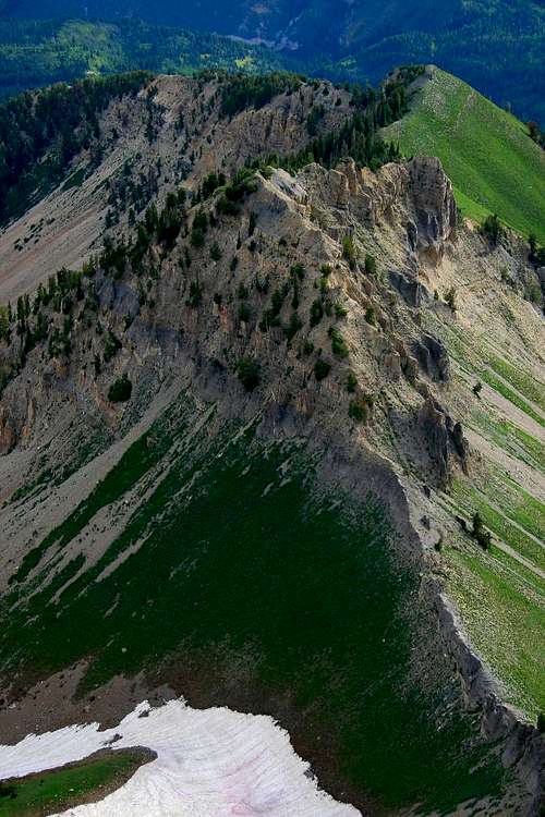 A good look at the south ridge's knife sections, from Bomber Peak.
 At the saddle of Bomber and Forgotten Peak, looking at Forgotten's south ridge.
 At the saddle of Bomber and Forgotten Peak, looking at Bomber's connecting ridge.
 From the summit of Forgotten Peak, looking south at the knife ridge portions.
North East Ridge. Class 2 and 3. .87 miles, 1,774 vertical feet.
This route starts 2.4 miles from the Timponeke Trail head on the trail. Just after making a sharp switchback on the trail to the south, begin making your way to the west to the base of the prominent north east ridge of Forgotten Peak. Be prepared for a decent bushwack on this one, especially in mid to late summer months when the vegetation is at it's most extreme. About 600 vertical feet of bushwacking has to be negotiated before reaching rocky terrain on the ridge above. From this point it is a matter of following the ridge steeply to the south west to a point at 10,109 feet. One benefit of this route is the intense amount of flowers seen along the way during mid summer months, and also an incredible deposit of fossils located about 70 yards from point 10,109 directly above on the ridge line. When following the ridge directly at this point, which is class 2, keep an eye out for a light gray limestone portion on the ridge. The fossils are located on this outcropping. The remaining portion of the route follows the ridge about 200 yards beyond the fossil location, where a large cliff about 100 feet tall blocks access. Contour around to the right, north, of the ridge and climb class 3 terrain to bypass this cliff. From the top of the cliff it is mixed class 2 and 3 terrain along the ridge for another 300-400 yards to the summit.
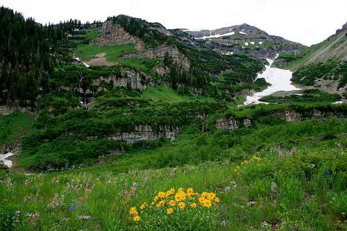
 Looking south at Forgotten Peak, with both the gully and north east ridge seen.
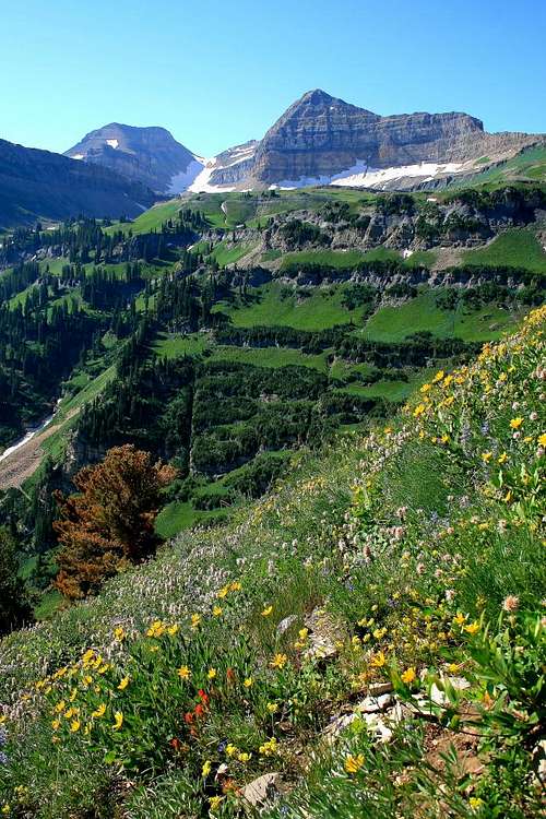 Typical scene to the south while on Forgotten's north east ridge line.
Geology.
Mt. Timpanogos' entire upper bulk is made of the Oquirrh Formation, which is a layered strata of limestone, mainly gray and light tan, with thin beds of quartzite. The age of the formation dates back to 270 to 325 million years old. In the gray colored limestone beds on the mountain fossils can be found, some places with more abundant deposits than others. The fossils exposed on Forgotten Peak's north east ridge at the gray limestone outcropping are very abundant, more so than on other portions of the mountain. The quality of the specimens, primarily shells, remain to be some of the best on Mt. Timpanogos! Fossil found at the saddle, no other specimens found.
 Fossil found at the north east ridge location.
 Fossil found at the north east ridge location, larger specimen.
  At the north east ridge location these fossils are abundant along a 20' slab.
  Utah Geologic Reference Chart.
Mountain Weather.
Mt. Timpanogos is one to check on with the weather before venturing out. The closest locations to the area discussed are Sundance Ski Resort, and the town of Alpine to the west. Two links for weather location are included below:Alpine, Utah weather link.
Sundance Resort, Utah weather link.
