
-
 6701 Hits
-
 81.84% Score
-
 14 Votes
|
|
Mountain/Rock |
|---|---|
|
|
34.72950°N / 83.961°W |
|
|
Union |
|
|
Hiking |
|
|
Spring, Summer, Fall, Winter |
|
|
3540 ft / 1079 m |
|
|
Overview
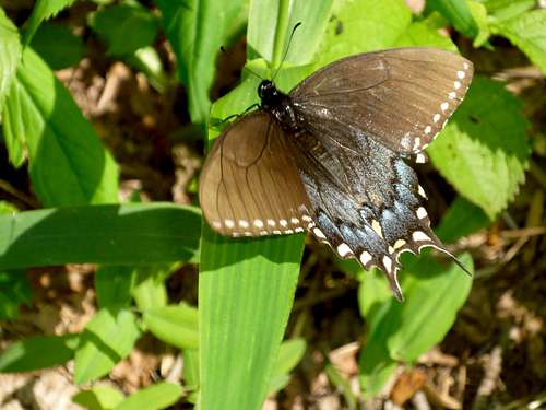 Spicebush Swallowtail
On the northwestern edge of the Blood Mountain Wilderness, roughly two miles west of the wilderness area’s namesake peak, Gaddis Mountain rises between Jarrard Gap and Horsebone Gap. The Appalachian Trail skirts the summit of Gaddis Mountain, requiring a short bushwack through moderate brush to reach the top.
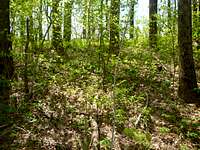
The views from the summit are not wide-open, but provide a descent, if timber-shrouded, look at the surrounding mountains. Dappled sunlight reaches the earth on Gaddis Mountain, fostering a riot of wildflowers in the spring.
USGS Topo: Neel Gap
Trails Illustrated Map: #777 Springer & Cohutta Mountains
Rank: Unranked
Prominence: 80 feet
Rank & Prominence Source: Lists of John
Getting There & Route Overview

Gaddis Mountain sits just off the AT between Woody Gap and Neel Gap. As such, backpackers or slackpackers (day hikers using shuttles to cover the AT) heading between these two major put-in points will pass very close to the Gaddis Mountain summit, and just a short tip-toe through poison ivy will get them to the top. The summit is roughly 4 miles south of Neel Gap and 6 miles north of Woody Gap.
This mountain can be access from the Lake Winfield Scott area off GA 180, and day hikers may wish to make a nice loop trail by linking Trail #141, the AT and Trail #142.
Red Tape
 Gaddis Mountain Trillium
 Across the summit of Gaddis Mountain
Gaddis Mountain resides within the Blood Mountain Wilderness in Chattahoochee National Forest. Standard wilderness restrictions apply (no motorized vehicles, pets on leash, etc.) Please practice Leave no Trace and be mindful of Forest Service user warnings posted at Woody Gap, such as “problem bear” alerts and campfire bans.
Camping & Lodging
 Brush between AT and summit
 Pink and White Trillium
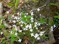 Small white wildflowers on Gaddis Mountain
 Blue Wildflowers on Gaddis Mountain
Dahlonega: A decent variety of lodging options can be found in nearby Dahlonega, GA, 15 miles south on GA Hwy 60 from Woody Gap. Visit this Trip Advisor page for details.
Suches: Suches, Georgia, is only six or seven miles north of Woody Gap on GA Hwy 60, but the lodging options are more limited.
Car Camping: Car camping can be found at nearby Dockery Lake, Lake Windfield Scott and Vogel State Park.
AT Backpacking: The nearest Appalachian Trail shelter to Gaddis Mountain is Woods Hole, approximately 1.25 miles northbound on the AT (plus a short access trail to the shelter).
Weather & Seasons
| Spring and Fall are considered by many the most pleasant time to visit the Southern Appalachians. Spring: In the Spring, daytime temperatures and warm and evenings are cool while the flowering shrubs are in bloom and the waterfalls are running. Water sources such as springs are most reliable this time of year. Fall: In the fall, the broadleaf deciduous trees put on a bright display of autumn color, though waterfalls may not be as impressive and springs and other water sources less reliable. The air is cooler and crisper and visibility should be prime for long-range views. Summer: in this part of the country can be oppressively hot and humid and even the higher elevation and ample tree cover will not keep the hiker from feeling overheated, sticky and dirty. High humidity and haze plus deep leaf cover mean limited long-range vistas, though it is in summer that the term “temperate rainforest” will have the most meaning to and be most appreciated by the visitor. Winter: in the South Appalachians can range from cool and damp to cold and severe with bouts of deep snow following major storms. In other words, while this range may be relatively low in elevation and southern in latitude, mountains are still mountains and can bring unpredictable and potentially dangerous weather. |