
|
|
Mountain/Rock |
|---|---|
|
|
37.81704°N / 79.1062°W |
|
|
Nelson County |
|
|
Hiking |
|
|
Spring, Summer, Fall, Winter |
|
|
4040 ft / 1231 m |
|
|
Overview

This a great hike anytime of the year I think. I planned on getting some fall foliage photos, but the time had passed. By 5 November all the leaves were gone. However, one cannot help but appreciate the scent of fall, the crisp clean air and stilll fresh fallen leaves of the forest. It was a balmy 26 degrees at 6:30 AM when I started my hike up to Maintop Mt.
Getting There

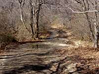

1.) Crabtree Falls Trailhead (Elevation 1,600 ft.). From Charlottesville, VA, travel west along I-64 to exit 99. Go South on the Blue Ridge Parkway to milepost 27. Go East on Rt 56 approximately 6.5 miles to the Crabtree Falls parking area, which will be on your right. There are about 55 parking spaces here and restrooms. Take tre trail up to Crabtree Falls and keep going part the falls to Crabtree Meadows where you'll come to Meadows Lane (dirt road). Turn left onto Meadows Lane and go .4 miles to the Appalachian Trail trailhead. Take the south AT on the right side of the road. From this point it is approximately 2.5 miles to Maintop Mountain. Total roundtrip distance: 11 miles.
2.) Crabtree Meadows Trailhead (Elevation 3,050 ft.): From Charlottesville, VA, travel west along I-64 to exit 99. Go South on the Blue Ridge Parkway to milepost 27. Go East on Rt 56 about 5 miles. Take a right onto Meadows Lane, a dirt road with several small stream crossings. Follow Meadows Lane for 4.4 miles to the AT trailhead. Take the south AT on the right side of the road. From this point it is approximately 2.5 miles to Maintop Mountain. Total roundtrip distance: 5 miles.
3.) Tye River AT Trailhead (Elevation 1,000 ft.): From Charlottesville, VA, travel west along I-64 to exit 99. Go South on the Blue Ridge Parkway to milepost 27. Go East on Rt 56 about 11 miles. Here you'll come to The Priest and Three Ridges Wilderness parking area for the Appalachian Trail. There is enough room in the parking lot for about 10 cars, but others parked along the road and that didn't seem to be a problem. This route is the longest and most strenuous. This route takes you over The Priest and south down the other side, crossing Meadows Lane about 4.5 miles from the trailhead. Total roundtrip distance: 14 miles.
4.) Fish Hatchery Road Trailhead: More information coming on this route, I have no first hand knowledge of it yet.