
-
 13132 Hits
-
 81.84% Score
-
 14 Votes
|
|
Mountain/Rock |
|---|---|
|
|
34.79840°N / 83.7299°W |
|
|
Towns & White |
|
|
Hiking |
|
|
Spring, Summer, Fall, Winter |
|
|
4020 ft / 1225 m |
|
|
Overview
 Clouds Break Up
Rising east of Unicoi Gap and west of Indian Grave Gap sits Rocky Mountain. While the peak has a rather boring and indistinct summit, it features great views to the south from the eastern end of the summit ridge. Dark, bare rock outcrops make for fine viewing platforms to take in scenery across the Andrews Creek valley to mountains in the distance.
There are no fewer than three ways to reach this peak, all with moderate mileage, including the Rocky Mountain Trail. Proximity to Helen, Georgia and Unicoi State Park combined with easy access make this a popular peak for day hikers seeking views as well as AT backpackers passing over the summit.
Georgia Rank: 18th highest peak in Georgia
Prominence: 920 feet
USGS Quad: Tray Mountain
Planning Map: The Appalachian Trail | Chattahoochee National Forest | Springer Mountain to Bly Gap GEORGIA (by Appalachian Trail Conservancy)
Rank & Prominence: Lists of John
Getting There
 Flame Azalea Flame Azalea | The nearest town to Rocky Mountain is Helen, Georgia, about 90 minutes north-northeast of Atlanta. This map shows you how to get there from surrounding communities, including Atlanta. |  American Millipede American Millipede |
 Indian Grave Gap
 Junction of AT and Rocky Mountain Trail
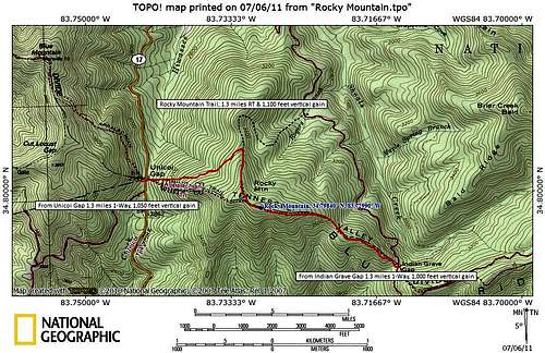
There are three primary routes to the summit of Rocky Mountain, each involving approximately 1.3 miles one-way and at least 1,000 vertical feet to reach the top.
From GA 75/17 (paved) at Unicoi Gap via the AT
• To reach Unicoi Gap, travel south on GA 75 11.6 miles from Hiawassee or north 9.2 miles from Helen.
• From Unicoi Gap (ample parking), head northbound on the Appalachian Trail.
• Follow the white blazes
• One-way distance: 1.3 miles
• Elevation Gain: 1,050 feet
From FSR 283 (dirt) at Indian Grave Gap (ample parking) via the AT
• Follow GA 75 south 9.5 miles from Hiawassee or 11.3 miles north from Helen to the intersection with Indian Grave Gap Road (FS 283). Continue 3.7 miles to the AT crossing.
• From Indian Grave Gap, head southbound on the Appalachian Trail
• Follow the white blazes
• One-way distance: 1.3 miles
• Elevation Gain: 1,000 feet
From FSR 283 (dirt) via Rocky Mountain Trail
• Follow GA 75 south 9.5 miles from Hiawassee or 11.3 miles north from Helen to the intersection with Indian Grave Gap Road (FS 283). Continue 2.3 miles to limited parking for Rocky Mountain Trail.
• From FSR 283 (limited parking), follow blue-blazed Rocky Mountain Trail to junction with white blazed AT. Then follow AT northbound to summit.
• One-way distance: 1.3 miles
• Elevation Gain: 1,000 feet
Red Tape
 AT sign at Unicoi Gap
 Recent Storm Damage
There is no fee to visit this part of the Chattahoochee National Forest and permits are not required for overnight stays in the backcountry. Please be mindful of posted Forest Service user warnings, such as “problem bear” alerts and campfire bans. Note that the Appalachian Trail is open to foot traffic only. Motorized vehicles and pack animals are not permitted. While it appears Rocky Mountain resides within the Swallow Creek Wildlife Management Area, a joint situation managed by Georgia and the National Forest Service, I can find no special considerations restricting access or use as a result.
Please practice Leave No Trace principals:
1. Plan Ahead and Prepare
2. Travel and Camp on Durable Surfaces
3. Dispose of Waste Properly
4. Leave What You Find
5. Minimize Campfire Impacts
6. Respect Wildlife
7. Be Considerate of Other Visitors
Camping & Lodging
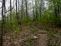 Ascending from the west
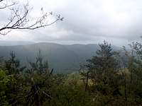 Views from sub-summit overlook
AT Backpacking
• Southbound: Blue Mountain shelter is the nearest shelter southbound from Rocky Mountain, 3.5 miles south on the AT.
• Northbound: The Tray Mountain shelter is the nearest shelter northbound from Rocky Mountain, 4.3 miles north on the AT.
Unicoi State Park
Nearby Georgia State Park Unicoi State Park features a lodge (100 rooms) and camping (82 sites), plus 30 cottages and something called the Squirrels Nest, a special group campsite of 16 platforms sleeping 4 each.
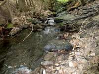 Cascade west of Rocky Mountain Cascade west of Rocky Mountain |  Leaving Unicoi Gap toward Rocky Mountain Leaving Unicoi Gap toward Rocky Mountain | 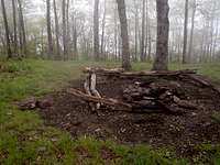 Summit area campsite Summit area campsite |
Weather & Seasons
| Spring and Fall are considered by many the most pleasant time to visit the Southern Appalachians. Spring: In the Spring, daytime temperatures and warm and evenings are cool while the flowering shrubs are in bloom and the waterfalls are running. Water sources such as springs are most reliable this time of year. Fall: In the fall, the broadleaf deciduous trees put on a bright display of autumn color, though waterfalls may not be as impressive and springs and other water sources less reliable. The air is cooler and crisper and visibility should be prime for long-range views. Summer: Summer in this part of the country can be oppressively hot and humid and even the higher elevation and ample tree cover will not keep the hiker from feeling overheated, sticky and dirty. High humidity and haze plus deep leaf cover mean limited long-range vistas, though it is in summer that the term “temperate rainforest” will have the most meaning to and be most appreciated by the visitor. Winter: Winter in the Southern Appalachians can range from cool and damp to cold and severe with bouts of deep snow following major storms. In other words, while this range may be relatively low in elevation and southern in latitude, mountains are still mountains and can bring unpredictable and potentially dangerous weather. | 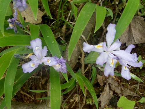 White Crested Dwarf Iris White Crested Dwarf Iris |