
-
 9128 Hits
-
 83.1% Score
-
 16 Votes
|
|
Mountain/Rock |
|---|---|
|
|
35.02270°N / 83.5841°W |
|
|
Clay |
|
|
Hiking |
|
|
Spring, Summer, Fall, Winter |
|
|
4740 ft / 1445 m |
|
|
Overview
 North Carolina-Georgia Border Line-Up
Ravenrock Ridge runs to the northwest from the main spine of the Blue Ridge Mountains in western North Carolina. The peak sits not far from the Appalachian Trail, and a blue-blazed route (which bypasses the true summit) takes hikers to a series of cliffy overlooks on the western side of the peak where blockbuster views await.
While the actual highpoint of this peak is indistinct and humdrum, covered in trees and shrubs, the cliff overlooks provide wide-open westward views of neighboring peaks and beyond. Close-up views include Courthouse Bald, Sharp Top, Rich Knob and Hightower Bald. From the cliff, the mountains beyond seem to roll forever as the western slopes of Ravenrock Ridge drop away underfoot.
Based on the narrow condition of the trail, it seems few AT hikers bother with the side-trip to Ravenrock Ridge. This is a shame, as the all-seasons views from these western cliffs are easily the best for miles in either direction along the trail.
North Carolina Rank: Unranked
Prominence: 120 feet
USGS Quad: Rainbow Springs
Planning Map:Appalachian Trail Conservancy Bly Gap to Fontana Dam NORTH CAROLINA
Rank & Prominence Source: Lists of John
Getting There & Route Information


 Follow the blue blazes
Ravenrock Ridge can be accessed from the north or the south along the Appalachian Trail or from the west via the Chunky Gal Trail.
AT Northbound (from the south)
• From Blue Ridge Gap, via the AT, hike 3.1 miles north to Bly Gap, then 2.7 miles to the turnoff for the Ravenrock Ridge Trail (total one-way distance to trail junction is 5.8 miles).
• Blue Ridge Gap is accessed by taking US 76 to Hightower Road. Per my map, Hightower Road is 4x4 the last few miles.
AT Southbound (from the north
• From Deep Gap, via the AT, hike 4.1 miles (one-way) to the turnoff for the Ravenrock Ridge Trail.
• Deep Gap is reached by taking US 64 to Rt 71 (graded gravel).
From the West
• A longer but apparently scenic option would be to approach the AT using the 5.5 mile Chunky Gal Trail.
• This trailhead is roughly 17 miles west of Franklin, NC, on Hwy 64.
From the junction of the AT and the blue-blazed Ravenrock Ridge side trail, the overlook cliffs are less than 4/10ths of a mile and 115 feet of elevation gain. The actual Ravenrock Ridge summit can be gained in passing by side-stepping the trail while high on the ridge, before descending to the cliffs, and charging through the woods briefly where the brush looks the least bothersome. The summit is indistinct and I found no cairn or marking indicating the top had been reached.
Red Tape
 Hightower Bald Hightower Bald | 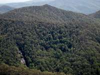 Sharp Top Sharp Top |  Courthouse Bald Courthouse Bald |
 West from Ravenrock Ridge
 Fine views to the west
There is no fee to visit this part of the Nantahala National Forest and permits are not required for overnight stays in the backcountry. Please be mindful of posted Forest Service user warnings, such as “problem bear” alerts and campfire bans. Note that the Appalachian Trail is open to foot traffic only. Motorized vehicles and pack animals are not permitted. Please practice Leave No Trace principals:
1. Plan Ahead and Prepare
2. Travel and Camp on Durable Surfaces
3. Dispose of Waste Properly
4. Leave What You Find
5. Minimize Campfire Impacts
6. Respect Wildlife
7. Be Considerate of Other Visitors
Camping
 Vandalism, mosquitoes and Copperheads at the Muskrat Creek Shelter
 Approximate highpoint
The nearest AT shelter is the Muskrat Creek Shelter, though I honestly cannot recommend spending the night here. The shelter has, unfortunately, been horribly vandalized. It is surrounded by shallow streams and seasonal standing water, providing prime habitat for mosquitoes and Copper Heads, among other critters. Also, during my visit in 2011, there were no bear cables present. While this may be a minor inconvenience to the prepared backpacker who will utilize other means (traditional rope hang, bear canister) to secure their food, it means the less prepared / less conscientious may not make efforts to secure their food. Upon arriving at this shelter in 2011, I encountered a sack of tortillas casually left on the structure’s railing, half gnawed on by animals.
Along the AT, there is camping 2.8 miles to the south at Bly Gap and 4.9 miles to the north at Standing Indian Shelter.
Weather & Seasons
| Spring and Fall are considered by many the most pleasant time to visit the Southern Appalachians. Spring: In the Spring, daytime temperatures and warm and evenings are cool while the flowering shrubs are in bloom and the waterfalls are running. Water sources such as springs are most reliable this time of year. Fall: In the fall, the broadleaf deciduous trees put on a bright display of autumn color, though waterfalls may not be as impressive and springs and other water sources less reliable. The air is cooler and crisper and visibility should be prime for long-range views. Summer: in this part of the country can be oppressively hot and humid and even the higher elevation and ample tree cover will not keep the hiker from feeling overheated, sticky and dirty. High humidity and haze plus deep leaf cover mean limited long-range vistas, though it is in summer that the term “temperate rainforest” will have the most meaning to and be most appreciated by the visitor. Winter: in the South Appalachians can range from cool and damp to cold and severe with bouts of deep snow following major storms. In other words, while this range may be relatively low in elevation and southern in latitude, mountains are still mountains and can bring unpredictable and potentially dangerous weather. |