
-
 9558 Hits
-
 80.49% Score
-
 12 Votes
|
|
Mountain/Rock |
|---|---|
|
|
34.82300°N / 83.6523°W |
|
|
Habersham, Rabun, & Towns |
|
|
Hiking |
|
|
Spring, Summer, Fall, Winter |
|
|
3780 ft / 1152 m |
|
|
Overview
 Luna Moth
Between Tray Mountain to the south and Dismal Mountain (topped by Round Top) to the north sits Blue Ridge Swag, or “The Swag of the Blue Ridge.” This swag is a broad gap running for approximately 3 miles (according to the Appalachian Trail Conference) and, with the exception of Young Lick, is characterized by only minor elevation change. Other sources, such as the Appalachian Trail Conservancy, indicate the span of the swag to be much smaller, perhaps one mile, beginning north of Young Lick, occupying the space between Young Lick and Dismal Mountain (Round Top). Young Lick, also identified on maps as Young Lick Knob, is the only named mountain along this stretch of trail and a welcome (if scarcely noticeable) diversion along the way.
Rising just 280 feet above its saddle with its next highest neighbor, Young Lick is a mellow hump along the ridgeline forming the Tennessee Valley Divide. Distanced from any roads and in dense forest, this area feels quite removed from civilization. The summit requires just a minor side-step eastward from the AT, and finding it means you stand in three counties at once, so you might as well claim the top while you pass by. As with many hills in this area, finding the summit means wading through undergrowth and stepping over logs until you satisfy yourself that you’ve found the highest patch of earth.
Rank: Soft Ranked (Young Lick is a soft ranked peak, which basically means there is no confirmed 300-ft variance between its summit and the lowest point of the saddle with its next highest neighbor.)
Prominence: 280 feet
USGS Quad: Tray Mountain
Planning Map: Appalachian Trail Conservancy | Chattahoochee National Forest | Springer Mountain to Bly Gap
Rank & Prominence: Lists of John
Getting There & Route Information
 Lightning Tree Closeup
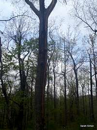 Lightning Tree
Young Lick can be accessed from the north or the south along the Appalachian Trail.
AT Northbound (from the south)
• From Tray Gap at Rt 79, via the AT, hike roughly 6.5 miles (one way) north to, through Blue Ridge Swag, to the highpoint of the AT along the upper western slopes of Young Lick. The summit is very indistinct and requires only a short side-step from the trail.
• Tray Gap is accessed by taking GA 356 east from Robertstown (1 mile north of Helen) for 5 miles. Turn left at Bethel Church onto Chimney Mountain Road. Follow Chimney Mountain Road for 2 miles to FS 79 (Tray Mountain Road). High clearance is required at this point; 4x4 is recommended. Follow FS 79 north 7 miles to Tray Gap. (Note intersection of FS 698.)
AT Southbound (from the north
• From Dicks Creek Gap, via the AT, hike approximately 5.7 miles (one-way) to highpoint of the AT along the upper western slopes of Young Lick. The summit is very indistinct and requires only a short side-step from the trail.
• Dicks Creek Gap is reached via paved US 76 east of the town of Hiawassee.
Red Tape
 Gentle Mountaintop
 AT crossing top of mountain
There is no fee to visit this part of the Nantahala National Forest and permits are not required for overnight stays in the backcountry. Please be mindful of posted Forest Service user warnings, such as “problem bear” alerts and campfire bans. Note that the Appalachian Trail is open to foot traffic only. Motorized vehicles and pack animals are not permitted. Please practice Leave No Trace principals:
1. Plan Ahead and Prepare
2. Travel and Camp on Durable Surfaces
3. Dispose of Waste Properly
4. Leave What You Find
5. Minimize Campfire Impacts
6. Respect Wildlife
Camping
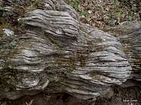 Fallen Oak
 Limited Views
Tent Camping Only
Sassafras Gap, roughly 1 mile northbound on the AT, has level spots for a few tents and a spring. There are no bear cables; you must do your own critter hangs.
Deep Gap Shelter | AT Northbound
Roughly 3.8 miles north of Young Lick on the AT
Tray Mountain Shelter | AT Southbound
Roughly 3.8 miles south of Young Lick on the AT
 Blue Ridge Swag
Weather & Seasons
| Spring and Fall are considered by many the most pleasant time to visit the Southern Appalachians. Spring: In the Spring, daytime temperatures are warm and evenings are cool while the flowering shrubs are in bloom and the waterfalls are running. Water sources such as springs are most reliable this time of year. Fall: In the fall, the broadleaf deciduous trees put on a bright display of autumn color, though waterfalls may not be as impressive and springs and other water sources less reliable. The air is cooler and crisper and visibility should be prime for long-range views. Summer: in this part of the country can be oppressively hot and humid and even the higher elevation and ample tree cover will not keep the hiker from feeling overheated, sticky and dirty. High humidity and haze plus deep leaf cover mean limited long-range vistas, though it is in summer that the term “temperate rainforest” will have the most meaning to and be most appreciated by the visitor. Winter: in the South Appalachians can range from cool and damp to cold and severe with bouts of deep snow following major storms. In other words, while this range may be relatively low in elevation and southern in latitude, mountains are still mountains and can bring unpredictable and potentially dangerous weather. |  Lady Slipper near the NC-GA border Lady Slipper near the NC-GA border |