Ideas for a free weekend
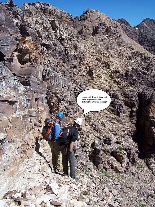
![Eastern slopes]() John Broadbooks gazing up at things to come
John Broadbooks gazing up at things to come
The Elk Mountain Range is by far my favourite mountain range in Colorado. The rock is resplendent with colour, flowers equally impress with delicate splashes paint, mountains are nothing more than broken cathedrals of strata and for some reason, even the lakes in this area seem wilder, warmer and more intriguing. Indeed, the Elks wouldn’t be what they are if everything wasn’t working harmoniously together.
But that’s just it. Is it harmonious? Anyone who has camped or waited through a thunderstorm in this rugged range knows how intense they can be. Wintertime for all extrinsic purposes basically shuts the whole range down save for the few stalwarts who endure the extra miles of approach. The upper echelons of the craggy peaks are a constant struggle between weather, placidity and gravity creating a Parthenon of chaos. Mountains, trying to rip and tear themselves apart: breaking, cracking, splitting and endlessly fracturing themselves into herculean piles of talus and scree. Loose rock and instability is the norm. Indeed, the Elks are,
“Evolution in action”.
Loose rock is challenging in ways that overall steepness (pitch), vertical gain and tough route-finding can’t touch. With these three tangents, there’s a measure of knowledge and experience that one can ‘bring to the table’ to minimize the risks and level the playing field, so to speak. But with rotten rock and terrain that moves, nothing can be trusted. There is no guarantee that an experienced crag/trad climber will be any more proficient than a class-2 novice. With loose rock, the unexpected reigns and all is suspect.
This is why I’ve come to appreciate and like loose rock. It requires using the same muscles that other mountaineering aspects use but in vastly different ways. Navigating loose terrain demands one’s full attention and route-finding becomes a moment-by-moment decision process. And there’s no better place for this than the high peaks and ridges of the West Maroon Creek Valley.
I first ascended Pyramid a few years ago solo via the
NW Ridge Route; the same route initially used by Percy Hagerman and Harold Clark in 1909 of the first ascent. I descended the now standard NE Ridge relishing that after four attempts, I finally made the summit
(weather in the Elks can be trite and unpredictable). The second visit was just last year with good friends Glen Maxson and Brian Miller. We descended the class-4 North Ridge on Thunder Pyramid and traversed the largely unknown connecting South Ridge of Pyramid Peak
(props to Jason Halliday for some useful beta!).
After Stephanie and I talked about what to do this past weekend, we decided on something in the Elks (anything in the Sawatch Range was definitely out!). She still needed the aforementioned peaks and I wanted to climb the last section of this anathemic and stupifingly loose ridge. That meant an alpine start and idyllic weather. So at 9:30am, standing on the summit of Point 13,631
“Len Shoemaker Peak”, we started the Pyramidal Traverse and finally finished some 9 hours and 1.8 miles later on top of Pyramid Peak.
![Looking south at 13,631]() Looking back at Point 13,631
Looking back at Point 13,631
We had company on the approach up into Len Shoemaker Basin and for the duration to Point 13,631 and traverse to “Lightning Pyramid”. John Broadbook was camping meaning to solo Point 13,631 and Point 13,586 (located between “Lightning Pyramid” and Pt. 13,631). We knew of each other via Fourteenerworld by way of random posts and trip reports. It was great to run into John and actually meet him. The three of us proved to be great scrambling partners! The class-2 slope leading up to the ridge to access 13,631 was not at all what we were expecting. Granted, the piles of talus and rubble at the bottom were enourmous but the slope itself was rock hard
(pun intended- Hahahah!). Everything seemed to be ‘cemented’ together which, was actually great. Also, trekking this far into the upper basin, I was finally able to spy a weakness in Len Shoemaker Ridge. A hidden, sloping gully accesses the ridge crest providing a way to the highpoint. It can’t be seen unless one hikes all the way in. I wonder if Mike Garrett used this to summit it.
The short scramble to the summit of 13,631 was surprising. It was typical Elk rock but very ledgy. The slopes, though more consistent in pitch and slightly easier were much looser than staying to the ridge crest which, held more sold rock. The views south to Precarious Peak were fantastic. I left a new register tube and paper and after maybe 10 minutes, we scrambled down fairly easily and quickly back to the saddle. It was time to tighten those straps, gear-up and put on our game faces…time for the serious stuff.
Ridge Section 1: Point 13,631 to "Lightning Pyramid"
Of the three segments that make up the entire ridge, the 0.7 mile portion running north from 13,631 to
“Lightning Pyramid” is by far the loosest. It is also, at least in my opinion the second least traversed. Perhaps this is why it was so enticing to climb and scramble. John, Stephanie and I left the comfort of the dirt saddle and walked north initially along the mild ridge crest dropping only once to the west for a couple hundred meters or so. And at that, this was only because it proved to be quicker to save on time. We did a fairly good job of spying broken ledges, narrows and short gullies that proved to be fruitful however, we still cliffed ourselves out on two separate occasions.
After half an hour of deciding and deciphering the ridge and possible routes, we followed John’s lead from a sticky spot. We dropped down to the west on a sharp descent angling into a small rubble filled alcove by way of a fractured shelf. Any fall here would have resulted in an eight foot slide before falling 25-30 vertical feet further down the slope. Imagine the backside (Southside) of Challenger Peak just after one gains the ridge…then cover it in Elk talus and rock. It was fairly similar. We climbed up into the alcove one at a time. The only way out was a tight, wrap-around sloping ledge that regained the ridge on the other side of a deep notch that we were unable to ford. After the three of us had negotiated this alcove and scouted the further ridge, we concluded it was impossible to continue on the crest.
The west side at this point completely cliffed out and the down climb to the east involved sloping steps too large with too much talus. This kinda put all of us in a pensive mood for a while. So once again, moving one at a time, we retraced our steps back to the comfort of more solid terrain back to a safe spot on the ridge and juggled our options. Stephanie suggested that the only way possible might be the east side with further investigating. She was right. I spied a narrow ledge about as wide as a sidewalk running parallel with a vertical wall on the left that looked like it might work. John descended first to inspect it…success! We took turns traversing and climbed out via a short but steepish ‘ladder’ with decent holds.
In hindsight, this was probably the coolest portion of the ridge! But it's always like that once you've safely negotiated the difficult sections, isn't it? The route continued without problems for a while. We crested the summit of Point 13,586 near 11:00am, more of a flat highpoint then a ‘summit’. After a short break, we descended and came to a cliffed out broken plateau, more of a widening of the ridge really. We gazed north out across the eastern slopes of “Lightning Pyramid” which, was now close enough to warrant detail. The three of us decided that any other forays out onto the west face would be futile and impassible.
Roughly 90% of this particular ridge segment was undertaken on the east side.
We backtracked a little bit, dropped down to the left (west) and immediately wrapped around to the crest again where the terrain turned dirty and muddy from a couloir. Again, taking turns, we plunge-stepped down the semi-hard mud staying off the snow/ice and rounded the corner from a craggy fin where the terrain became easier for a short spell again. My original plan to scale “Lightning Pyramid” was by way of a prominent gully on its eastern flank. It wasn’t nearly as steep as simply climbing straight to the ridge but it looked nightmarishly loose. The more I thought about it, I’d rather be on steep terrain that holds better odds of having sold rock then playing the odds in a rubble gully like that. More than likely, it served as a funnel for everything above it. “Lightning Pyramid” was almost directly overhead at what had to be on a 70˚-80˚ pitch. I was able to find some short clefts to climb linking them by 4-5 move traverses until we gained the ridge crest again. From there, it was a loose class-3 scramble of 5 minutes to the summit which, we made just after noon. I was still surprised at how steep this last pitch just reared up. At least the holds were adequate. In my opinion, this particular segment is only slightly less-confusing then going from Thunder to Pyramid Peak. It would be pointless to build cairns because they would only be pummeled apart by years end anyway.
Ridge Section 2: "Lightning Pyramid" to "Thunder Pyramid"
![Descending 2]() Descending Thunder Pyr
Descending Thunder Pyr One of the best parts I like about Elk rock is the crenellations, waves & ripples, features and
‘petroglyphesque’ markings the sandstones carry. Once at the shoreline of a massive great sea, the rock in the Elks is mostly tidal mud, shoal, salt and gypsum, shore-sand, clay and reef limestone. Because of fault openings and consequential volcanic activity, uplifting and fracturing, a large portion of the Elks are actually capped by igneous rock. Add to that, an increase of inland movement of sedimentation to the shore and you have a blanket of thin and weak rock. The north, class-3 ridge of 13,722 is a welcome sight. It’s basically a broken sidewalk that descends to the saddle with Thunder Pyramid. I built a larger cairn here and unfortunately, we had to part ways with John. He had prior engagements with a CMC trip two days hence.
After taking this moment to eat and drink
(Stephanie and I have a bad habit of pushing ourselves with little to no nourishment) we started the second leg of the traverse. Since I’d already climbed this section two years prior as a snow climb with Jamie Princo, Jamie Nellis and Mark Milburn, I knew exactly what to expect. I was looking forward to it because I was curious exactly how much easier this would be in the other direction. This portion is only 0.4 miles but definitely the steepest. In terms of looseness, it’s not bad, all things considering because this segment gets climbed periodically, so there’s a lot of ‘cleaning’ that takes place. We did a short wrap-around from the initial 5’ step and contoured back to the left to the spine of the ridge.
The first half of this ridge has some exciting and on occasion, very exposed 4th class and even low 5th class moves (only because of the exposure). Using your forearms to mantle, kicking your feet up at waist level, pulling & pushing out simultaneously and generally not looking down will serve you well on the short steps however this is only if one stays to the crest. Most of these exposed moves can be avoided by staying to the ledges and eastern slope. However, the trade-off is looser talus, scree and Leafy Thistle (I personally hate the bastards!).
On a ridgeline where comfort is a hard sell, ‘pick your poison’.
Stephanie and I climbed a bit slower on this section taking extra care since it was only the two of us now. The pitch of the ridge gradually lets off the closer to Thunder Pyramid you get. The views down the west side into West Maroon Creek from this vantage are breathtaking! The slope is uninterrupted by towers, fins or small buttresses. I can say that this segment was much easier and faster going south to north. This is also where we started to notice the odd cairn or two. We plopped down on the summit and tore into our food. This was Stephanie’s first ascent and my third. We noted
Steve Gladbach’s & Cooper’s (dog) name in the register. This was just an all-out fun ridge segment to climb, more because it didn’t take all our mental focus to stay on track or route-find. The ridge crest is a straight shot; just some decent and fun 4th class scrambling. The
Moss Campion and
Alpine Forget-me-nots on the dirt patches were a welcome sight from the monotonous reds, rust and ashen granite.
Ridge Section 3: "Thunder Pyramid" to Pyramid Peak
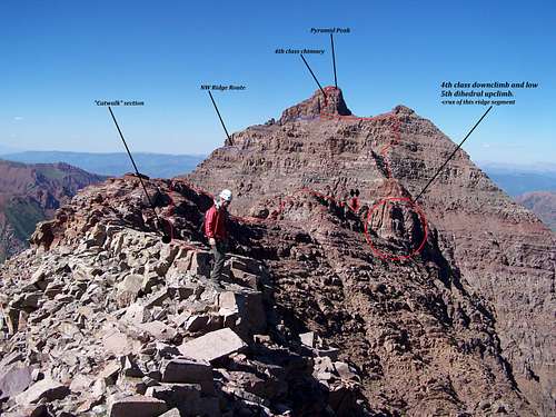
![Labeled South View]() Looking north towards Pyramid Peak from the 'Catwalk'
Looking north towards Pyramid Peak from the 'Catwalk'Launching into the unknown…well, almost unknown save for Brian’s, Glen’s and my traverse last year in exactly the same direction Stephanie and I were to depart. Jason Halladay and Bill Geist attempted this traverse in the south to north direction a few years back and were turned around due to some weather and time issues. They went back I believe a year or two later and completed it. We received a lot of beta from Jason on it.
This is the second longest portion of the ridge coming in at 0.6 miles. The route finding is actually the trickiest and the possibility of making a mistake by ascending too early or traversing too far is the greatest. The amount of loose rock is second only to the first portion back by 13,631 and it’s a close second at that. The crux of this ridge segment is probably the hardest of the three and bail options are limited at best. I’d be lying if I didn’t say this last portion didn’t make me nervous. But emotions like that are better left unvoiced. Apprehensiveness and anxiousness are incredibly contagious. Last time, we almost raced through most of this section due to incoming weather/storms and still got pelted with rain and hail on the summit of Pyramid Peak. So a good portion of it is mostly a blur.
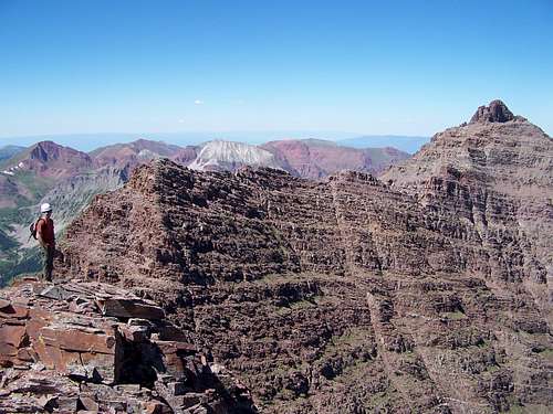
![Thunder Pyramid- Pyramid Peak Ridge]() "Thunder Pyramid"-Pyramid Peak Ridge
"Thunder Pyramid"-Pyramid Peak Ridge
We started the 4th class down climb of the north ridge. The crest is punctuated by multiple 3’-5’ steps, typical loose talus & scree and the occasional ‘turn-in’ corner. Some of this can be avoided by descending small scree slopes and linking traverses but again, I’ll take any possibility of solid rock over that crap. Plus, Stephanie and I have a ‘thing’ of taking the harder route if it exists. C’mon, that’s how you get used to this stuff! You can’t get better if you’re not consistently challenging yourself!
The down climb took a little while but we took another short break at the wide, dirt col. This is actually a pretty good bail-out option to the west if need be. The views are almost completely unobstructed to the valley floor. Looking up at the first gendarme from here is Point 13,820. It is an unranked and largely ignored ‘highpoint’ along the ridge. This gendarme is nasty and scary. This is something that I wouldn’t attempt to climb even if I had the time. It’s probably the nastiest piece of business along this whole 1.8 mile ridge.
We started on a slight ascending traverse to a good ledge on the west side of 13,820 and wrapped around it following a good ledge system. Above us on the right were countless small towers, pinnacles, tight gullies, fins, rotten crags et al that constantly threaten to shower down and let loose rock. Though the movement is good and secure it’s not wise to dawdle or linger if you don’t have to…and we didn’t. I’ve been to the Elks a lot in my time and nowhere have I come across an area that more closely resembles ancient, rotten and forgotten cathedrals of grandeur of what could have possibly once resembled the walls of Moria (if it existed). This 0.2 mile portion of ridge must be traversed lower down on ledges on the west side. The ledges weave in and out of a few recessed gullies and couloirs disappearing on occasion only to be swallowed up by talus slides, steep-corner down climbs and reappearing again seemingly at random. The scrambling through this actually doesn’t exceed easy 4th class but it is stupifingly loose and the temptation to gain the ridge too early is prevalent. After a few gullies, roughly three or four I believe, I spied what looked familiar.
Stephanie and I scrambled up or more like swam up a noticeable narrow cleft in the ridge filled with rubble and large plate talus. The col is quite narrow at this point but a small ledge wraps around back to a higher ledge system (can't be seen until you actually top out) and some easier terrain ensues for a short while. Stephanie and I took this to our advantage and kicked up our speed a little to try and make up for lost time back on the down climb of Thunder Pyramid. We eventually crossed back over to the west side on unassuming ledges until the ridge rose up suddenly on our right. This was ok because the traversing was becoming easier and the pitch of the slope lessened. We left the tight confines of the west slopes and ridge and things opened up.
We could see part of Pyramid’s NW Ridge Route! Ah! We were getting close! Things were finally becoming very familiar from last year. We scrambled up to the ridge (again) on easy talus and hit what I call the ‘Catwalk’ section. It’s very similar to the sidewalk on Eolus and ends on a small widening breach of the ridge. It’s a great place for a break because it’s exceedingly flat and it provides spectacular views of Pyramid Peak and the last section of vulgarities. Stephanie and I took our longest rest here studying the crux and filling up before the end. I tried to be jovial in a Falstaffian manner but both of us were getting tired and hungry. All I could eek out were some smiles. The impending crux was kinda on my mind anyway.
We packed up and walked over to the terminus of the ridge we were on. I didn’t want to repeat our down climb of this from last year simply because we were tired and it’s exposed as all hell. It’s basically a loose, 4th class, face down climb on suspect ledges. A slip on this face and you wouldn’t stop for a couple hundred feet. Stephanie asked about a hidden, lichen and moss covered corner that we had missed the previous year.
“Looks good, let’s do it!” I said with no hesitation. I started down climbing facing out (I know, poor form) and eventually turned in once I reached some ledges I liked. I remember because once I turned in, I dislodged a stop sign-sized flake of rock that I carefully rocked back into place. I got to a good safe-zone and watched Stephanie climb down waiting to tell her of the ‘surprise rock’. Fortunately, she climbed down further from where I was and started to traverse down to the col. From the small dirt col, traversing to the east side is not an option…not yet. The cliffs are too steep and the ledges completely disappear at the crest of each successive fin. I climbed up a slightly zigzagging ledge (initially easy 3rd class then easy 4th class) to the bottom of a 25’-30’ vertical dihedral. The holds in this tight corner are small and slightly down sloped but not bad. I’m guessing it has to be 5.0 maybe 5.2 at most. It’s not exposed but any fall is going to take you all the way down back to the gully where the col is situated, some 40’. At the top of this corner, an awesome ledge awaits! I yelled down to Steph to ”Come on up! This sh*t’s almost done!” After some maneuvering with her camera, she promptly climbed up with no problems. We started traversing again on what was initially scary and narrow ledges but they gradually widened and the gully I was looking for came into view. It’s not as steep as heading straight up which, I believe you can do but it all marks the end of the difficulties once you reach the ridge.
I hugged Stephanie fiercely once on top and we continued our movement on terrain that turned into class-2 all the way to the bottom of the 4th class chimney that marks the final summit push for Pyramid Peak. This is also the terminus for the NW Ridge Route. The chimney was longer then I remembered it to be but the rock is solid, holds are great and aplenty. Cairns mark that you’re in the right one. Too far to the right (east) and the face falls away into oblivion.
We both really enjoyed this last push and Steph remarked that she’s never been happier to see signs of people! Our summit celebration

lasted only 10 minutes or so but boy was it sweet! We made the rock amphitheater before dark and took one more break in the dark below tree line watching the stars and witnessing about six shooting stars of which two left good trails. I raised a friend who was staying down at Crater Lake (Britt) on the walkie-talkie whom was camping over at Crater Lake with friends. We talked for a little bit, wished them good luck up on Pyramid tomorrow then Stephanie and I slow-tailed it out there where we promptly collapsed in her car ‘round 10:30pm. The Pyramidal traverse is definitely one for the books and a solid highlight of 2010 for what has been a fairly dismal year.


Comments
Post a Comment