
-
 1079 Hits
-
 78.27% Score
-
 9 Votes
|
|
Mountain/Rock |
|---|---|
|
|
Hiking, Skiing |
|
|
Spring, Summer, Fall, Winter |
|
|
8783 ft / 2677 m |
|
|
Overview

Glungezer is a well known and easily accessible summit of Tuxer Alpen (Tux Alps) and stands high above the town of Innsbruck. Together with the eastern located Malgrübler, Hirzer and Gilfert, Glungezer is in the northernmost chain of high Tuxer mountains, thus being the northwestern pillar of this area.
The summit itself is a rather disappointing feature. It is the highest point of several rocky bumps along a ridge, which continues to the south to the neighbouring summits of Gamslauerspitze and Tuxer Kreuzspitze. To add to the disappointment there is an old cable car mountain station, ski lifts on the north slopes, a huge alpine club hut and some antennas. Many people use the Glungezer cable car active in summer up to Tulfeinalm, about 600 m of altitude difference below the summit.
Nevertheless the views from the summit are awesome and there are some very fine, beautiful and rather lonely routes up to the top. I will describe them below.
Peakbaggers will have a feast: Nearby Sonnenspitze, Gamslauer Spitze, Tuxer Kreuzspitze to the south or Patscherkofel, Viggarspitze and Neunerspitze to the west are great traverse options with some additional summit triumph.

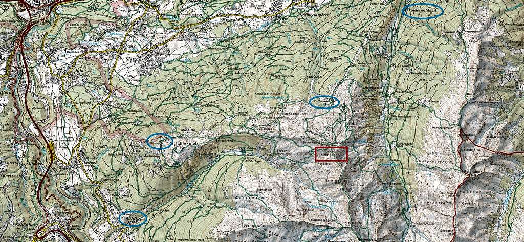
Glungezer and its ridges are bordered by Voltertal valley to the east, Inntal valley to the north and Viggar valley to the west, the first and the latter giving access to ous summit on lonely and beautiful trails.
The most precious thing about Glungezer and the whole area, however, is a tree: called Pinus cembra in Latin, Zirbe or Zirbel in Tirol and Bavaria, Arve in Switzerland. This astonishing and precious tree with many uses deserves an article on SP. A panoramic trail, starting at Patscherkofel cablecar mountain station and ending at Tulfeinalm below Glungezer, bears its name: Zirbenweg. Winding itself through the Zirben groves on the north slope of Patscherkofel and Glungezer, Zirbenweg is one of the highlight hikes in the area of Innsbruck.
So Glungezer is more than worth a visit.
Getting There
Trailheads for Glungezer are:
- Patscher Kofel cablecar mountain station
- Tulfeinalm / Glungezer cable car mountain station
- Sankt Peter/Mühltal and Meissner Hütte
- Volderwildbad above the village of Volders and parking area Voldertalhütte

Patscher Kofel cablecar starts at the road between the villages of Patsch and Lans, called Römerstraße.
- Use highway A 13, Innsbruck – Brenner, exit Patsch to Patsch and to Lans.
- Use highway A 12, Kufstein – Landeck, exit Innsbruck Mitte and proceed to Aldrans, Lans and take the road Römerstraße to Patsch.
- For public transportation take bus number J from Innsbruck railway station to busstop Patscher Kofel cablecar.
Glungezer cable car can be reached
- by exiting highway A 12 at Hall Mitte.
- Take the road to Volderwald and to Tulfes with the valley station of the cablecar.
- Bus number 4134 goes from Innsbruck railway station to the busstop Tulfes Glungezerbahn.
For those who want to make a roundtrip Patscherkofel cablecar – Glungezer – Glungezer cable car there is a special Zirbenweg ticket and bus number 4132, serving both valley stations.

Sankt Peter / Mühltal can be reached
- on the Ellbögen road starting at Patsch.
- Use highway A 13, Innsbruck – Brenner, exit Patsch to Patsch.
- Take the right hand road, signed for Ellbögen. Follow this road to Mühltal village. Turn left where the road crosses Mühltal creek and proceed this road alongside Mühltal creek to the parking area of Meissner Haus.
Bus number 4141 serves the busstop at Mühltal. The bus starts at Innbruck railway station.
You reach Volderwildbad / parking area Voldertalhütte
- on Großvolderbergstraße, which starts at Volders / Inntal valley.
- Leave highway A 12, Kufstein – Innsbruck, exit Wattens, enter Wattens village and follow the signposts shortly to Volders.
- Follow the signposts to Großvolderberg at a traffic circle.
- Reaching Volderwildbad there is a first parking area at a road switchback.
- Following the road, branching off at the switchback, brings you deeper into Voldertal valley and to a parking area near Voldertalhütte. This last part is a toll road.
- There is no public transportation from Volders to Volderwildbad.
Routes Overview
Glungezer topo features
Glungezer routes overview
Trailhead Patscherkofel cablecar mountain station:
- Zirbenweg to Boscheben – righthand trail to Glungezerhütte – summit
Trailhead Glungezer cablecar mountain station:
- Tulfeinalm – Schartenkogel – Glungezerhütte – summit
- alternatively Tulfeinalm - Glungezer via ferrata (rated B/C) to Glungezerhütte - summit
- Round trip Patscherkofel route – descend to Glungezer cablecar mountain station – back to Patscher Kofel cablecar via Zirbenweg


Trailhead Sankt Peter / Mühltal:
- Mühltal parking area – forest road to Meissner Hütte – trail to Boscheben - righthand trail to Glungezerhütte – summit; alternatively:
- Meissner Haus – forest road into upper Viggar valley, trails to Glungezerhütte and Glungezer
- Round trip possible
Trailhead Volderwildbad or parking area Voldertalhütte:
- Forest road to Voldertalhütte – Tulfeinalm – Schartenkogel – Glungezerhütte and Glungezer


Other routes and route combinations are possible. The Glungezer area has many trails and tracks.
Traverse routes:
- Naviser Hütte – Klammalm – Klammschober or
- Lizumer Hütte – Klammschober, then
- Sonnenspitze – Grünbergspitze – Grafmartspitze – Rosenjoch – Kreuzspitze – Gamslauerspitze – Glungezer
Long traverse, breathtaking landscape!


Ski routes:
- Most common ski route for Glungezer is the ascent from Tulfeinalm / Glungezer cablecar.
- Sonnenspitze, Viggarspitze and Neunerspitze can be combined to a loop route.
- Ski descent to Tulfes possible using the many crisscrossing forest roads cutting through the wood zone.
- An epic ascent starts at Inntal valley, parking area Karlskirche near Volders and uses the meadows and forest roads up to Kleinvolderberg – Tulferberg – Kugelwald – Tulfeinalm and Glungezer. Nearly 2200 m of altitude difference. Enough snow necessary as the route starts at about 550 m sealevel.
- From Sankt Peter / Mühltal via Viggar valley; from upper Viggar valley great slopes offer different routes up to the summit.
Red Tape & Accommodation
Red Tape:
No restriction as far as I know.


Accommodation:
The Innsbruck region offers a huge variety of accommodation.
Important tourist towns and villages around Glungezer are:

Mountain huts:
- Patscherkofel Schutzhaus
- Meissner Haus
- Boscheben
- Glungezer Hütte
- Tulfeinalm (only food and drinks)
- Voldertalhütte
Gear & Mountain Condition
Glungezer is an easy hiking summit for summer and autumn.
- You need good hiking gear. The traverse Gamslauer Spitze to Kreuzspitze requires easy scrambling.
In winter and spring, Glungezer is a wellknown ski tour.
- The Glungezer cablecar shortens the ascents significantly and makes some interesting loop routes possible.
- You need ski tour and avalanche gear.
- See the avalange bulletin here.


Meteo overview
Valley weather: Innsbruck
Mountain weather: Glungezer summit
Maps

Alpenvereinskarte, scale 1 : 25000
number 33, Tuxer Alpen
different maps for ski routes and for trails, with UTM grid
Alpenvereinskarte, scale 1 : 50000
number 31/5, Innsbruck