
-
 23147 Hits
-
 94.24% Score
-
 46 Votes
|
|
Area/Range |
|---|---|
|
|
47.19345°N / 11.64688°E |
|
|
Hiking, Mountaineering, Skiing |
|
|
Spring, Summer, Fall, Winter |
|
|
9468 ft / 2886 m |
|
|
1 - Overview
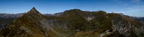
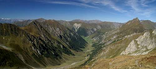 Summit View Frauenwand: Tux Alps above the Kaserer Winkl Valley |
North of the ice covered giants of the Zillertal Alps, between the Zillertal Valley itself and the broad Inntal Valley you find a small mountain range, the Tux Alps. Named for the villages, valleys and glaciers of Tux and Hintertux, this range is often overlooked. Though it is located in the heart of the Alps, almost at its geographical centre, the range is sometimes even called Tux Pre-Alps. Indeed the range does not look overly impressive with its smooth slopes and pastures, but nevertheless it reaches heights of almost 2900m.
Compared with its neighbours to the north, the Northern Limestone Alps ranges of Karwendel and Wetterstein the summits are tame, compared to its southern and western neighbours the Zillertal and Stubai Alps it is low and still it deserves to be visited. In summer the inner regions of the range are very solitary, thanks to their remoteness while the areas around the ski- and chairlifts of Innsbruck, Tux or Mayrhofen can be very crowded, especially on weekends.
The same lifts serve the ski runs of the area in winter and it is then that most visitors come to the region. They probably won’t remember the Tux Alps as such but rather the sloped they skidded down, but that’s a fate most heavily developed ski resorts share. In the northern centre of the group the Austrian military operates a training area which is closed down for the public whenever there is a manoeuvre. In consequence this area can be very lonesome when open, even though it has been developed with several high reaching mountain roads.
The highest mountain of the Tux Alps is Lizumer Reckner at 2886m, which can be found in the centre of the range (but still within the military training area). It is a rocky summit which can be reached by the only Klettersteig (Ferrata) of the Tux Alps, a short but steep route, rated UIAA I without the cabling.
2 - Panorama
|
MorgenköpflÜberfallgründlMorgenkopfMislkopfKreuzspitzeRosenjochGrünbergspitzeGrafmartspitzeNaviser SonnenspitzeSchoberBendlsteinSunntigerHochgeneinerjochSumpfkopfSchafseitenspitzeReisenschuhLizumer SonnenspitzeNaviser RecknerLizumer RecknerGeierSägenhorstBleijägerspitzeÖfner HornspitzeWandspitzeWeiße WandFrauenwand
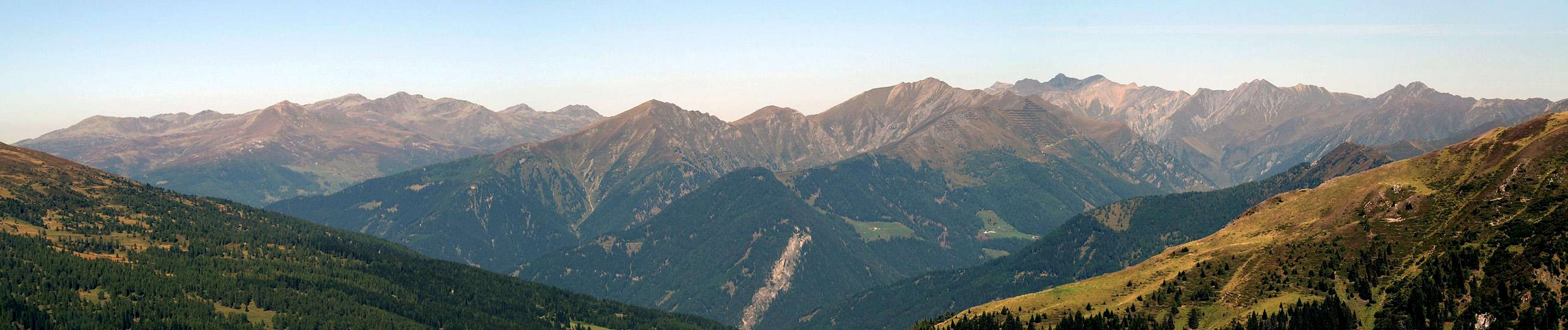  |
The above panorama gives a good impression what the Tux Alps look like and why sometimes they are called Tux Pre-Alps. Most of the range consists of smooth slopes, covered by meadows and pastures with only the highest summits being comparatively rocky. Among its neighbours the Tux Alps often vanish and you need a good vantage point like Allerleigrubenspitze in the eastern Stubai Alps to catch the skyline of the range at all.
3 - The Tux Alps on SP
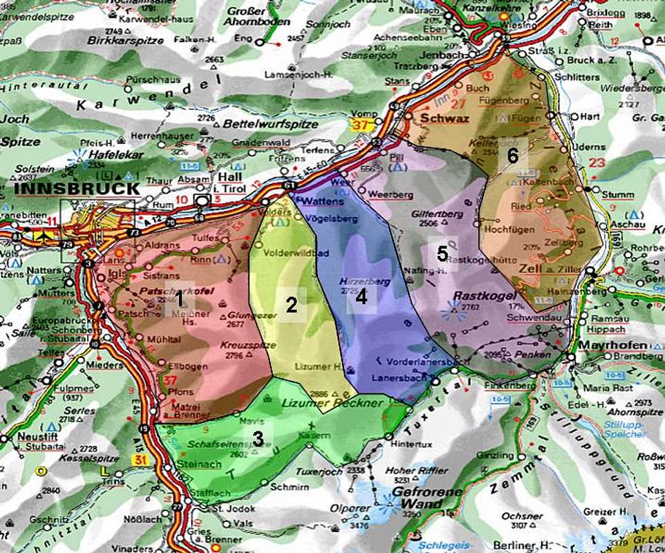 |
I didn’t find any official grouping structure for the Tux Alps so I “invented” my own. For most of the subgroups the grouping is quite obvious, since the Tux Alps are divided in several north-to-south running ridges, separated by profound valleys. Only in the south and east the structure of the ridges is more complicated so that I introduced an additional southern subgroup while dividing the easternmost ridge into two parts. I’m open for discussion for that structure.
Right now on SP the Tux Alps are divided into six subgroups, five of which run north to south while the southernmost one runs east to west. The subgroups have been named by their highest or most profound summits.
- Rosenjoch Group
- Reckner Group
- Southern Ridges
- Hirzer Group
- Rastkogel / Gilfert Group
- Marchkopf / Kellerjoch Group
4 - Rosenjoch Group
 |
The north-westernmost subgroup of the Tux Alps is located south-east of Innsbruck. With Patscherkofel and Glungezer it contains two popular ski summits which are connected by numerous hiking trails. The group is bounded by Inntal in the north, Wipptal in the west, Navistal in the south and Volderstal with the Navisjöchl Saddle in the east. Its highest summits are Kreuzspitze, Rosenjoch and Grünbergspitze, all located within a few hundred metres of each other and all reaching between 2700 and 2800m. The summits of this subgroup command great views over Innsbruck towards the Wetterstein and Karwendel Ranges.
4.1 - Main Ridge
- Patscherkofel (2246m)
![]()
- Neunerspitze (2285m)
- Viggarspitze (2306m)
- Schartenkogel (2311m)
- Sonnenspitze (2639m)
- Glungezer (2677m)
![]()
- Gamslahner Spitze (2681m)
- Kreuzspitze (2746m)
- Rosenjoch (2796m)
- Grünbergspitze (2790m)
- Grafmartspitze (2720m)
4.2 - Side Ridges
- Signalkopf (2273m)
- Morgenköpfl (2216m)
- Morgenkogel (2607m)
- Mislkopf (2623m)
![]()
- Seeblesspitze (2628m)


5 - Reckner Group
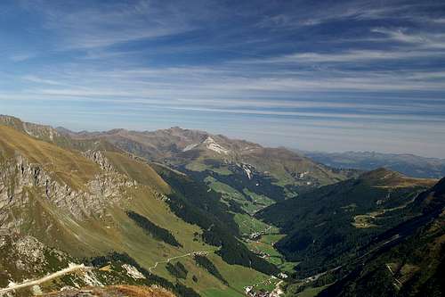
 The upper Navis Valley
Like most of the other subgroups of the Tux Alps the Reckner Group is a north to south running ridge, bounded by two profound valleys. To the east you find Voldertal Valley, while to the west the boundary is Wattental Valley. The southern boundary are the high passes of Griffjoch and Junsjoch to the east and west of Lizumer Reckner. The Reckner Group contains the highest mountains of the Tux Alps, all grouped around Reckner and reaching more than 2800m. This part of the group belongs to the military training ground Wattener Lizum and is prone to periodic closures (see red tape). Thanks to the military there are several high reaching roads, effectively connecting many of the summits of this main ridge.
- Largoz / Glotzen (2214m)
![]()
- Wattenspitze (2321m)
- Rosskopf (2382m)
- Haneburger (2596m)
- Malgrübler (2749m)
- Sunntiger (2667m)
- Seekarspitze (2646m)
- Naviser Sonnenspitze (2610m)
![]()
- Nördl. and Südl. Schober (2448m)
- Mölser Sonnenspitze (2489m)
- Mölser Berg (2479m)
- Klammspitzen
- Tarntaler Köpfe (2757m)
- Lizumer Sonnenspitze (2831m)
- Lizumer Reckner (2886m)
![]()
- Naviser Reckner (2824m)


6 - Southern Ridges
 The south-eastern ridge of the Tux Alps
The only ridges, which don’t run north to south can be found in the south of the Tux Alps. Bounded by the Schmirn and Tux Valleys in the south and the Navis Valley in the north two ridges run into the centre of the group from both east and west, culminating near Lizumer Reckner. Both ridges are excellent hiking grounds with a vast net of hiking trails. Most summits can be climbed easily, with the exception of the mountains in the very south, Öfner Hornspitze and Gamskarspitze. The former is a grassy pyramid with a very exposed south ridge, a very interesting destination from the Tuxer Joch Saddle in the south. In this saddle the Tux Alps meet the Tux Main Ridge, the eastern- and southernmost subgroup of the Zillertal Alps.
6.1 - South-Western Ridge
- Sumpfkopf (2341m)
- Reisenschuh (2470m)
- Schroffkogel (2151m)
- Bentlstein (2436m)
![]()
- Sunntiger (2400m)
- Schafseitenspitze (2602m)
- Scheibenspitze (2429m)
- Hohe Warte (2398m)
- Kreuzjöchl (2536m)
6.2 - South-Eastern Ridge
- Öfner Hornspitze (2650m)
![]()
- Ofner (2493m)
- Gamskarspitze (2750m)
- Geschützspitze
- Wandspitze (2614m)
- Kettenspitze (2179m)
- Bleijägerspitze
- Krsitallner
- Sägenhorst (2713m)
- Pluderling (2778m)
- Dunkle Spitze (2479m)
- Hochwartspitze (2491m)
- Madseitberg (2292m)


7 - Hirzer Group
Hirzer or Hirzerspitze might not bet he highest mountain of this group but thanks to ist isolated location in the north it is more singular than the higher mountains in the south which group around Lizumer Reckner, the highest mountain of the Tux Alps. This subgroup consists of a single ridge, running from north to south with only small side ridges to all sides. The ridge is bounded by the Wattens Valley to the west and the Weer Valley to the east reaching up to Junsjoch Saddle and Geiseljoch Saddle respectively. To the north the group is bounded by the Inn Valley while in the south the Tux Valley is its limitation.
- Sattelkopf (2051m)
- Grüblspitze (2395m)
- Zinten
- Torwand (2771m)
- Kalkwand (2826m)
- Reuterturm
- Graue Wand (2594m)
- Torspitze (2663m)
- Eiskarspitze (2611m)
- Hippoldspitze (2643m)
![]()
- Almkogel (2419m)
- Hobarjoch (2512m)
- Hubertusspitze (2205m)
- Krovenzspitze (2619m)
- Hirzer (2725m)
- Wildofen (2553m)
![]()
- Sagspitze (2401m)
- Poferer Jöchl (2318m)
- Rote Wand (2217m)


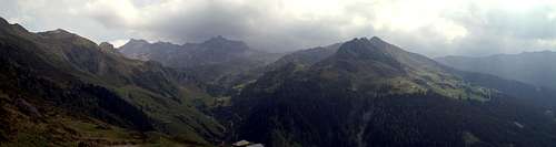
8 - Rastkogel / Gilfert Group
 The Rastkogel Group above the Tux Valley
Like most of the other subgroups the Rastkogel / Gilfert Group runs through the whole Tux Alps from North to south. With 2762m Rastkogel, which is located in the south of the subgroup, is its highest summit. To the north, a little separated from Rastkogel and its satellites is second subgroup, grouped around Gilfert (also Gilfertberg). Rastkogel is best known for the ski runs on its south slopes above the villages of Mayrhofen and Finkenberg. The boundaries of the group are Zillertal in the south and east, Inntal in the north and the Weer Valley with Geiseljoch Saddle in the west.
- Hoarbergkarspitze (2278m)
- Schafskopf (2294m)
- Gschößberg (2005m)
- Penken (2095m)
- Wanglspitze (2420m)
- Lämmerbichl (2278m)
- Graue Spitze (2552m)
- Sandegg (2360m)
- Pangert (2550m)
- Grindlspitze (2635m)
- Rastkogel (2762m)
- Halslspitze (2574m)
- Nafingköpfl (2454m)
- Hoher KKopf (2372m)
- Rosslaufspitze (2248m)
- Alplköpfl (2141m)
- Dreispitzkopf (2604m)
- Breitenkopf
- Rosskopf (2576m)
- Kleiner Gilfert
- Pfaffenbichl (2431m)
- Metzen (2355m)
- Gilfert (2506m)
![]()
- Nonsjöchl (2112m)
- Sonntagsköpfl (2244m)
- Graukopf (2195m)
- Großer Gamsstein (2142m)
- Kleiner Gamsstein (1924m)

9 - Marchkopf / Kellerjoch Group
This easternmost subgroup of the Tux Alps can be divided in two parts. In the north, above the villages of Schwaz and Straß there is a small group, consisting of a single mountain, Kellerjoch, and its satellites. To its south, across the Fügen / Hochfügen Valley there is a slightly larger group with Marchkopf as its highest summit. Like most of the mountains of the Tux Alps these summits are smooth and often covered with pastures. On the east side of this subgroup several roads lead high onto the pastures, mainly serving the ski runs and mountain farms.
9.1 - Marchkopf Group
- Arbiskopf (2133m)
- Mittenwandskopf (2336m)
- Kraxentrager (2423m)
- Gipfel (2445m)
- Marchkopf (2499m)
- Krösser (2243m)
- Wimbachkopf (2442m)
- Öfelerjoch (2162m)
- Hüttenkogel (2386m)
- Gedrechter (2217m)
- Drisslkopf (2069m)
9.2 - Kellerjoch Group
- Kuhmesser (2264m)
![]()
- Kellerjoch (2344m)
![]()
- Metzenjoch (2313m)
- Gratzenkopf (2087m)
- Spieljoch (1862m)


10 - Getting There
The closest airport is Innsbruck Kranebitten, right to the north-west of the Tux Alps.
- For the western part of the group take Brenner Highway B182 (not the motorway) southward. Until you get to Stafflach the Tux Alps are on your left hand (eastern) side. At Stafflach the Schmirn Vallley runs eastward, along the southern borsers of the group.
- For the northern part of the Tux Alps take B171 though Innsbruck. The motorway A12 also is an alternative but you have to pay a 7 day toll. Between Innsbruck and Straß you will have the Tux Alps to your right (south).
- For the eastern and southern parts of the group head out on A12 or B171 through Innsbruck. At Straß turn south onto B161 which leads to Mayrhofen in the Zillertal Valley, with the Tux Alps to your right (west). Between Mayrhofen and Finkenberg a side road turns westward into Tux Valley, ending at Hintertux. Here the Tux Alps can be found in the north.
11 - Red Tape
About 50 square kilometres of the Tux Alps have been set aside for a military training area, the “Truppenübungsplatz Wattener Lizum”. The northern parts of the Reckner and Hirzer Groups belong to that training area and the highest mountain of the whole group, Lizumer Reckner is also part of it. While in general the whole range is open for hiking and trekking, during military manoeuvres it gets closed.
Signs are posted along all trails which lead into the area, requesting you to make sure that the region is open. Unfortunately I have not been successful in obtaining phone numbers or addresses. Therefore I guess it is best to enquire in the villages before you set out for a hike.
12 - Mountain Huts and Refuges
| Refuge / Hut | Height | Summer | Winter | Tel. | Thumbnails |
| Glungezer Hütte | 2610m | mid June – mid Oct | Dec – mid April | +43/5223/78018 | |
| Gschößwandhaus | 1784m | all summer | all winter | +43/5285/62880 | |
| Kellerjochhütte | 2237m | June – end Oct. | closed | +43/664/2202612 | |
| Lizumer Hütte | 2019m | mid June – end Oct | Christmas – beg. May | +43/5224/52111 | |
| Meißner Haus | 1720m | all summer | all winter | +43/650/8511430 | |
| Naviser Hütte | 1787m | all summer | all winter | +43/5278/6209 | |
| Patscherkofel-NF-Haus | 2000m | all summer | all winter | +43/512/584144 | |
| Patscherkofelhaus | 1970m | all summer | all winter | +43/512/377196 | |
| Rastkogelhütte | 2124m | June – Oct | Christmas – Easter | +43/664/9207523 |  |
| Vinzenz-Tollinger-Hütte | 1229m | all summer | all winter | n.a. | |
| Voldertalhütte | 1376m | May – Oct. | self service | +43/664/4801851 | |
| Weidener Hütte | 1799m | all summer | Nov closed | +43 664 88109940 / +43 5224 22525 |  |
13 - Accommodation
Each of the towns and villages of the area has a homepage with the possibility to book hotel rooms and apartments. Follow one of the links below.
13.1 - Inntal
- Innsbruck
- Tulfes
- Hall
- Wattens / Wattenberg
13.2 - Wipptal
- Steinach
- Matrei
- St. Jodok / Schmirn
- Navis
13.3 - Zillertal
- Strass
- Fügen
- Fügenberg / Hochfügen
- Aschau
- Zelll
- Mayrhofen
13.3 - Tuxertal
- Finkenberg
- Tux
13.4 - Camping
- Plankenhof Camping
14 - Weather Conditions
In addition to the weather information on the sites you find under accommodation you can look up this general site:
15 - Maps & Books
15.1 - Maps
- Digital Maps
- Regular Maps
- Zillertaler Alpen / Tuxer Alpen
Kompass Map WK 37
1:50.000
ISBN: 3-85491-042-8 - Vorderes Zillertal
Kompass Map WK 28
1:50.000
ISBN: 3-85491-030/4 - Innsbruck / Brenner
Kompass Map WK 36
1:50.000
ISBN: 3-85491-040/1
- Zillertaler Alpen / Tuxer Alpen
15.2 - Books
There are no guidebooks dealing solely with the Tux Alps. Most books are ski tour books which reflects the importance, skiing has in the area.
- Zillertaler Alpen (Nördl. Teil) und Tuxer Voralpen
Alpenvereins-Gebietsführer
Walter Klier
Rother Verlag
ISBN: 3-7633-3258-8 - Zillertaler und Tuxer Alpen. Skiführer
Alpenvereins-Skiführer
Rudolf Weiss
Rother Verlag
ISBN: 3-7633-5233-3 - Kitzbüheler Alpen, Tuxer und Zillertaler Alpen
Alpenvereins-Skiführer
Sepp Brandl, Gerhard Hirtlreiter
Rother Verlag
ISBN: 3-7633-5910-9 - Ski-Touren für jede Jahreszeit rund um Innsbruck
Rudolf Weiss, Siegrun Weiss
Geocenter Verlag
ISBN: 3-7022-2404-1
selinunte01 - Apr 15, 2020 5:04 am - Voted 10/10
Mölser SonnenspitzeHi Gangolf, just a very tiny correction, as I climed this mountain lately: Mölser Sonnenspitze is 2489 m high. Cheers, Michael