
|
|
Mountain/Rock |
|---|---|
|
|
44.50260°N / 70.99777°W |
|
|
3870 ft / 1180 m |
|
|
Overview
Goose Eye Mountain, located in the wild and remote Mahoosuc Range, is a little known summit with some outstanding attributes. Goose Eye supports relatively expansive alpine plant communities on each of its three summits, as well as on numerous windswept ridgelines. Views are unobstructed and impressive in all directions. The massive Presidential Range dominates the southwestern horizon and views to the west take in much of New Hampshire’s north country. Maine’s third highest peak, Old Speck, rises sharply to the northeast with Baldpate and the rest of the Longfellow Mountains beyond. The northeastern side of the mountain is comprised of a well defined cirque which features some fairly impressive rockslides.
Of Goose Eye’s three peaks, west peak is the highest at 3,870 feet and ranks 78th on the New England Hundred Highest List. The east and north peaks are only slightly lower at 3,790 and 3,675 feet, respectively. The Appalachian Trail runs over Goose Eye and takes in many of the views described above.
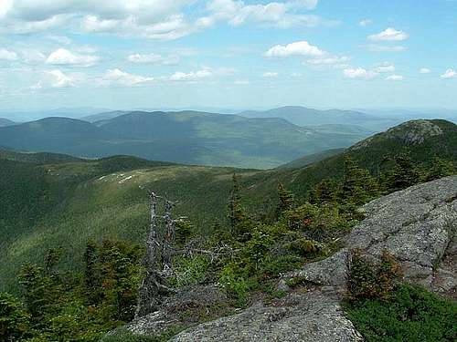 View east from Goose Eye's west peak.
ROUTE INFORMATION
Wright Trail:
The Wright Trail approaches Goose Eye from the east and follows Goose Eye Brook up into a large cirque. The upper part of the trail splits into two forks that make for a nice loop when used with the AT. The Maine Bureau of Public Lands recommends using the north fork for ascent and the south fork for descent.
The lower part of the trail closely follows Goose Eye Brook and there are numerous pools, cascades, and some pretty little waterfalls. The trail even skirts a 30 foot gorge for a short distance. At approximately 2.5 miles, the trail splits into the northern and southern forks. The northern fork continues to follow Goose Eye Brook as it begins to climb moderately from the valley floor. The trail comes out on a rockslide allowing impressive views of Goose Eye’s cirque and the many rockslides that line the bowl. The trail begins to climb more steeply and eventually meets the AT (also called the Mahoosuc Trail) in a saddle between the east and north peaks. To reach the two highest Goose Eye peaks, as well as the junction with the southern fork of the Wright Trail, head south along the AT immediately climbing the open slabs of east peak. The AT descends a steep 0.1 miles to a saddle where it meets the south fork of the Wright Trail. While it’s possible to head down here, west peak is only 0.5 miles south along the AT and well worth the extra mile.
The descent down the southern fork of the Wright Trail follows an exposed, windswept ridge for over a mile before descending sharply into the valley below. Views from the ridge are nearly as impressive as those found on the summits. Total mileage for the loop is approximately 9 miles (8 miles if you skip west peak) with close to 3,000 feet of elevation gain.
Goose Eye Trail:
The Goose Eye Trail approaches from the west on the somewhat infamous Success Pond Road. Known for being a bit difficult to navigate, Success Pond Road is a primary logging road that is crisscrossed by numerous, smaller side roads. According to the Maine Mountain Guide (AMC, 8th ed.), distance from the trailhead to the west peak of Goose Eye is 3.1 miles and the trail is generally considered easy with one exception being a potentially dangerous scramble in wet or icy conditions.
 |
 |
 |
Getting There
The Wright Trail ascends the eastern side of Goose Eye from Bull Branch Road. To access the trailhead, head north out of Bethel, Maine on RT 26 towards Sunday River Ski Resort. Turn left onto Sunday River Road and follow for approximately 7 miles past the Artist’s Covered Bridge (watch for a sign). The pavement ends and the road will eventually turn left and cross two steel bridges and then almost immediately turn right again. You’ll eventually pass a parking area and a privy on the left. This parking area is for a swimming hole in Bull Branch. Continue on for approximately 1 mile and the trail will leave the left side of the road. There is a small parking area just beyond the trailhead.
As previously mentioned, approaching Goose Eye via the Goose Eye Trail requires navigating Success Pond Road. See the Mahoosuc Range page for info regarding directions from Berlin, New Hampshire, as well as some good general info regarding the road itself.
Red Tape
Goose Eye Mountain is located in the 30,000+ acre Mahoosuc Public Reserved Land managed by the Maine Bureau of Parks and Lands. Visitors need to be prepared for a rugged, remote backcountry experience as public reserved land units are not staffed as state parks and the Mahoosuc Unit is particularly remote. There are no fees for use but access is via private roads and drivers should use caution as logging trucks always have the right of way.
 |
 |
 |
Camping
There are a few tent sites just off the Wright Trail where it splits into the north and south forks. Additionally, the Carlo Col Campsite is located along the AT approximately 1 mile south of Goose Eye’s west peak. The Full Goose Shelter is also located along the AT approximately 2 miles north of Goose Eye’s west peak in a saddle between the north peak and neighboring Fulling Mill Mountain.
Mountain Conditions
Goose Eye can be climbed year round but unplowed access roads can make for a very long day in the winter. The upper reaches of the mountain are exposed and care should be used if conditions are less than ideal. The south fork of the Wright Trail has a steep slabby area that could be potentially dangerous in wet or icy conditions, as does a short section of the Goose Eye Trail. Hikers should be prepared for cooler temps and plenty of wind above treeline.
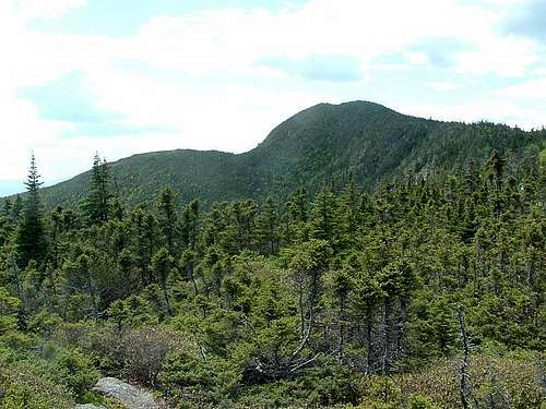 Goose Eye's west peak from the south fork of the Wright Trail.
External Links
An excellent trip report written by SPer Scottie277 can be found here.