-
 6200 Hits
-
 83.1% Score
-
 16 Votes
|
|
Mountain/Rock |
|---|---|
|
|
44.09091°N / 114.98386°W |
|
|
Custer |
|
|
Hiking, Mountaineering, Trad Climbing, Sport Climbing, Toprope, Bouldering, Ice Climbing, Aid Climbing, Big Wall, Mixed, Scrambling, Via Ferrata, Canyoneering, Skiing |
|
|
Spring, Summer, Fall, Winter |
|
|
9622 ft / 2933 m |
|
|
Overview
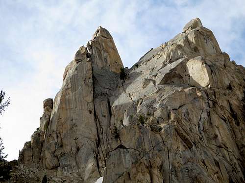
Location: In the Redfish Lake Area of the Sawtooths; on the south slopes of Mt. Heyburn, and just across from the Elephant's Perch
Nearby Peaks: Heyburn, Elephant's Perch, Split Tooth, Small Aiguille, Black Aiguille, Quartzite Peak, Braxon Peak, West Tower
Linkups: Black Aiguille, Small Aiguille, Split Tooth, Braxon
Difficulty: Class 5.4 on the rock (2-3 pitches), Class 3-4 on lower part of rock, Class 2-3 on approach
Usage: Rock Climbing
Terrain: Typical jagged Sawtooth tower- steep talus slopes below with smooth granite summit blocks. Rock is moderately solid on route, but lots of loose stuff elsewhere. Lakes below.
Traffic: Extremely light traffic. Perhaps one ascent per year on average mostly because of a lack of info and more known climbs nearby (Elephant's Perch, Heyburn) Still, rap anchors were found.
Summit Register: Yes, Nalgene container placed in 2011 with one signature. Original summit log was not found.
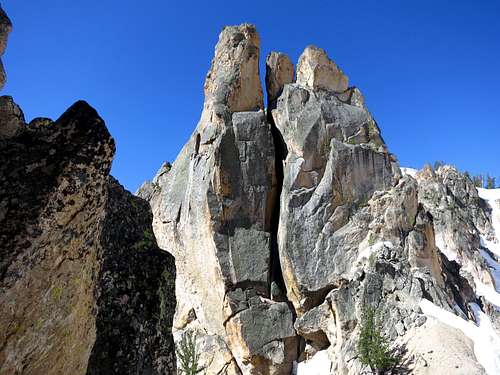
History / Entomology: Aiguille means a sharp pinnacle of rock and Grand indicates it's the largest of the group of towers in the area. One of the first ascensionist also has Grande as a last name. First Ascent by J. Hieb, W. Grande, R. Widrig, and W.V. Graham Mathews in 1946. Beckey and Fuller did the South face in 1962

Getting There
Nearest Paved Roads: ID-75
Nearest Dirt Roads / Conditions: RedFish Lake Road (paved)
Approach Trails / Conditions: Redfish Creek Trail from Redfish Inlet. Utilizing the Redfish Shuttle Boat saves 10 miles RT
Routes
Note: The latest Lopez book has the Grand Aiguille mislabeled on the "in book" map. The wording and description is accurate, though. Just remember The Grand Aiguille is west of the Small Aiguille which is west of the Black Aiguille.
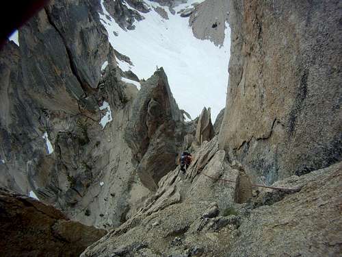
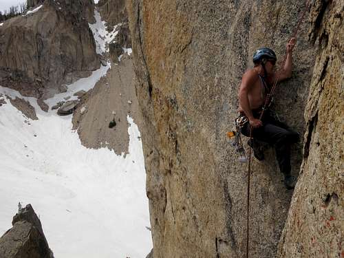
From the saddle, scramble Class 3-4 up ledges and ramps until you are behind a very large and prominent flake. The easier way is to climb under and to the left (north) of the flake. Once above the flake, the climbing begins with a large slot that is bypassed by climbing right out onto the face with mostly solid flakes. Once above the slot, you'll see an old piton (we rapped off of it). At this point you'll need to ascend the chimney which ranges from 8-14 inches wide. The face has little to grab and most of it is loose. Carrying a pack up this chimney was troublesome and we hauled it. Use your feet with opposing pressure until your at another piton and a tiny chock stone. Continue up to a large chock stone with a bunch of slings. There is a nice ledge here.

Climb above the chock stone to the right (south) until your at a nice ledge with a tree above. Climb past the tree on ledges and flakes back toward the north slightly. Soon the climbing turns to Class 3-4. There is a prominent notch along the summit ridge. Ascend that and follow easy, but exposed slabs to the summit. The south summit is higher, but the north summit is also a fun little scramble.
Descent: Down climb about 50 feet below the summit past the summit notch. There was a group of blue slings, but this rap station is set up so the rope could easily get stuck on pull (it did for us). Instead opt for the newer rap station just 10 feet up and to the north of the original. This rap hangs down better over more vertical rock. Still, be wary of the chimney swallowing the rope. This rap should take you to another rap station just to the south of the major flake. From here, this should take you back to the saddle above the couloir. Down climb or rap from the saddle back to the cirque, or descend the scree slopes to the south.
Gear: Single rope, long slings, a few nuts, webbing, ascender (or prussic) in case the rope snags. The route is steep, but the series of cracks can wreak havoc with your rope.
Main Route Stats: 4.9 miles / 2968 (round trip) or 14.9 miles without shuttle boat.
Average RT Time: 7-9 hours
Other Routes: South face has been reported climbed, but without detail. The impressive north wall beckons to be done as it appears to be all solid granite.
Red Tape
Permit: No
Other Users / Issues: Pack Animals
Maps: USGS Quad- Mount Cramer SW
Guide Book: Tom Lopez, Idaho: A Climbing Guide,