
-
 3069 Hits
-
 79.78% Score
-
 11 Votes
|
|
Mountain/Rock |
|---|---|
|
|
47.18570°N / 13.30329°E |
|
|
Hiking, Skiing |
|
|
Spring, Summer, Fall, Winter |
|
|
7280 ft / 2219 m |
|
|
Overview
Gurenstein - the view on Radstaedter Tauern

Hiking by the ridge
Despite a decent altitude, Gurenstein is quite a marginal, unimportant mountain. Some of its neighbours - in the same ridge for example Draugstein, 2358 m, and Glingspitze, 2433 m, are much more beautiful and worth mountaineers' goals. As it happened that we were not able to ascend Draugstein (Jasmina's injury, poor weather forecast), I am still happy to describe at least Gurenstein. At the end, it offers a nice ridge hike and a wonderful view on the mountains across Kleinarltal.
Some of the neighbouring mountains, especially those on the east, are made of limestone. They are a bit higher, rugged and harder to be ascended. But Gurenstein and the neighbouring summits are made of a kind of shale. The summit is rounded, covered with grass till the top and easily reachable. Actually, there are pastures till the very top of the whole ridge and less than 500 m below it you will find a few nice alpine meadows with big huts, offering also food and drink.
Due to its minor importance, Gurenstein is rarely the only goal of a hike. But the round tour on which you do a crossing of a good portion of the ridge is quite rewarding. Typically, you can include three summits and three saddles, travelling all the time above 2000 m aof altitude, enjoying a nice panorama. In winter, the whole area is very appropriate for tour skiing. It is a bit remote and the approaches can be long, but the terrains are very nice and worth visiting. At that time you will be on those mountains very likely alone.
Geography

Karteiskopf
Towards the north, the attractive summit of Draugstein rises. From it, the ridge runs towards the east on Scheibenkogel, 2251 m, where it turns south. On Draugsteintoerl our area of interest begins. The first summit south of that saddle is Karteiskopf, 2203 m, then Gurenstein, 2219 m comes and finally there's Kreuzeck, 2204 m. All these summits are easily reached by marked routes from the east and west.
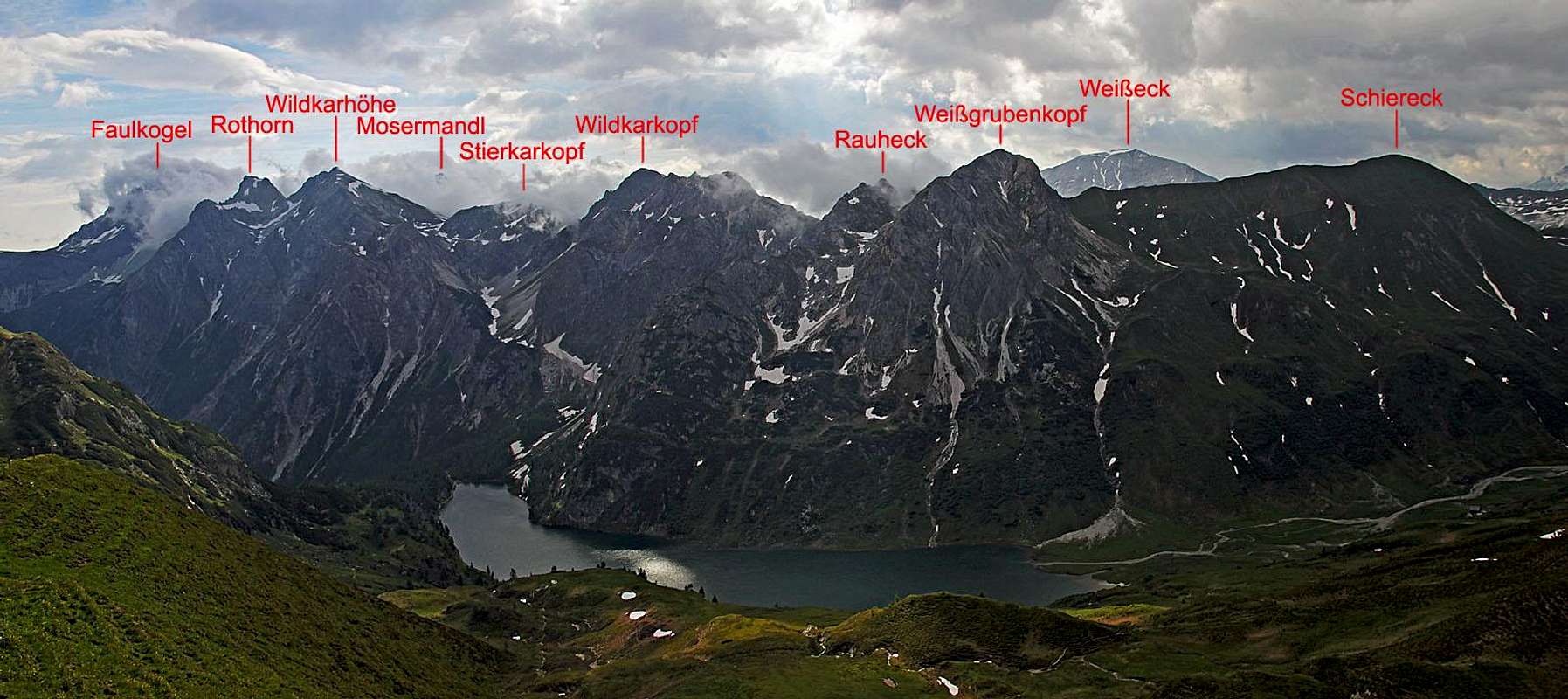
The Views Around
If we had better weather, I believe that I could judge the views towards south, on the main streak of Hohe Taurn summits as a very beautiful one. Still, I guess the view towards east, on the rugged Radstaedter Tauern is the winner there. Even more, as the beautiful Tappenkarsee lies so peacefully below the wild summits. Towards the west, the views are more open, as only a few summits of Hohe Tauern side ridges exceed our standpoint by altitude.Getting There

Karteis
Grossarltal is reachable from the town of St. Johann. You drive till the small village of Karteis, where you turn left, drive through the village and up across the steep slopes of Karteisgraben. The road is officially opened till the parking place (and crossroads) on 1300 m, the place is called Halmoosalm. When we were there, many visitors were parking on 1300 m, but many cars, I guess locals with permission, were also driving higher up (the gate was opened).
Ascent Routes
Crossing Gurenstein
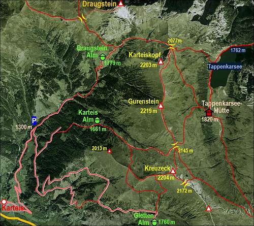
You can do any combination of the marked paths, seen on the sketch. Gletten Alm must be also an attractive goal of a mountain bike tour. Here are some options:
1. Go from the parking place above Halmoos Alm first towards the NE (by Karteisgraben and later meadows) on Draugsteinalm, 1778 m. 1 h 15 min. From there continue in the same direction, and then eastwards on Draugsteintoerl, 2077 m. 45 min. Then ascend Karteiskopf, 2203 m. The path avoids the rocky N ridge by the left (eastern) slopes, but you can also go across the western slopes (a few steep passages there). 30 min. Then just continue by the easy, panoramic ridge towards the south. You cross Gurenstein and reach Karteistoerl in another 1 h. From there, you can descend westwards. Over Karteisalm you will reach the parking place in less than 2 h. Or, you can continue by the ridge also on Kreuzeck, 2204 m. From there, you can descend either via Karteisalm or (longer) via Glettenalm. The last option will prolongate your tour for another 1 h.
2. From Kleinarltal ascend first to Tappenkarsee, 1762 m and further to Tappenkarseehuette, 1820 m. Some 3 h till there (from Schwabalm 2 h). Then you can do the round tour in any direction, including in it visits of Karteiskopf and Gurenstein. Some 2 h 30 min to return back to the hut.

Draugstein
Draugstein
None of my business, I know, because we have not ascended this nice summit. But when you are already on Draugsteinalm, the sharp peak is looming just above your head. That's actually the most attractive tour in the close-by area. So, from Draugsteinalm, you continue some 10 minutes towards the NE and then on the crossroads turn left. The marked path crosses the slopes towards the NW, reaching Filzmoossattel, 2062 m. There you turn right again, towards the summit. The first grassy ridge is nice and quite easy, later the steep ascent over the rocky summit section requires safe step and some care. Parts are also secured with cables. From the huts on Draugsteinalm officially 2 h, but as it is less than 600 m of altitude, it should be a bit less.
Mountaun Huts

Draugstein Alm
On the western and southern side there nice alpine meadows, with huts, where you can get food and drink and on some you can also sleep:
> Draugstein Alm, 1779 m. Two big huts, all service there.
> Gletten Alm, 1760 m. I guess a bigger hut with all service.
> Karteis Alm, 1661 m. A smaller hut there.