
-
 6039 Hits
-
 81.18% Score
-
 13 Votes
|
|
Mountain/Rock |
|---|---|
|
|
46.81000°N / 12.25000°E |
|
|
8100 ft / 2469 m |
|
|
Overview
Geographical Classification: Eastern Alps > Hohe Tauern > Villgraten Group > Hochstein - Rischterpfarrer
This page needs photos!
The subjects of this page are two moderate montains which are located in the Villgraten Group of Hohe Tauern. Both Hochstein / Sasso Alto (2469m) and the lower Rischterpfarrer / Corno di Vallesella (2239) stand out on a short ridge which leaves the Riepenspitze Subgroup of this range. Both are connected by a short ridge and are connected by a popular hiking trail. Thus both summits are climbed in unison most of the time. There are two ascent routes, one from the north from the village of St. Magdalena, the other from the south from the village of St. Martin. A third route - a somewhat exposed ridge traverse - runs towards the two mountains from the Riepenspitze Subgroup main ridge. Please compare the following hand made map for the location.
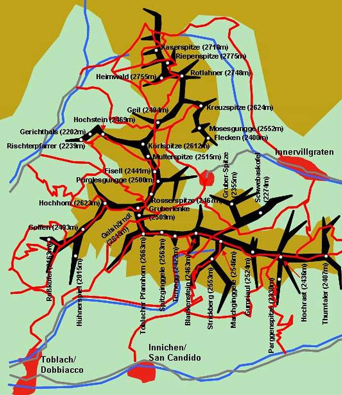
Hand made schematic map of the Riepenspitze Subgroup of Villgraten / Hohe Tauern. You can find Hochstein and Rischterpfarrer to the west of the group.
There is a third summit between the two mountains, Gerichthals (2202m). Both names, Gerichthals and Rischterpfarrer seem to indicate what we call Richtplatz in German, a place of execution. Presumably - but this is my own interpretation - the mountain were named this way because the local gallows poles used to be standing there. For everybody to see...
Today, as said in the introduction above, the mountains are rather popular among hikers. Popular, however is a relative term. They are popular compared with other mountains in the Riepenspitze Group since they are great lookout peaks almost central to the Gsies / Casies Valley, from which they can be reached. This Valley, however is rather remote and relatively lonesome in summer. Most visitors prefer the Sexten / Seto or Prags / Braies Dolomites to the south.
As befits lookout peaks, in 1999, when we climbed both Rischterpfarrer and Hochstein, I forgot to take pictures of the mountains themselves. Mathias Zehring, who has posted several shots of the Riepenspitze Group on the Villgraten Page seems to have missed them too. So if anyone can post shots of these elusive summits, please don't hesitate to post them here.
 |  |  |
Getting There

The Villgraten Group of Hohe Tauern. Hochstein and Rischterpfarrer are to the west of subgroup 4.
Hochstein and Rischterpfarrer can be reached reached from the south, from Pustertal / Val Pusteria. Here are the itineraries for Welsberg / Monguelfo, where the road into Gsies / Casies Valley starts northward.
Western Approach
Take the Brenner / Brennero Motorway A22 from Innsbruck (north) or Verona (south). At Brixen / Bressanone turn onto SS49 into Pustertal / Val Pusteria. Turn north at Welsberg / Monguelfo into Gsies Valley where you can stop at St. Martin or St. Magdalena.
Northern Approach
Take B161, Felbertauern Road, from Kitzbühel south. After passing Felbertauern Tunnel take the road to Lienz, where you can turn west ino Pustertal Valley. Go to Welsberg / Monguelfo and turn north
Eastern Approach
Take Motorway A2 from Klagenfurt to Villach. There turn onto A10 north which leads you to Spittal. A little north of Spittal turn west onto B100, which follows the Drau River Valley to Lienz and on into Pustertal Valley.
Southern Approach
Take motorway A27 from Venezia north to Belluno. At the end of the motorway take SS51 north to Cortina d'Ampezzo an on to Toblach/Dobbiaco. Here you are already in Pustertal Valley. Go west and turn north at Welsberg / Monguelfo.
 |  |
Red Tape
No red tape here. Keep in mind that the Austrian - Italian border is just a km to the east so be sure to bring ID-documents.
When To Climb
The normal hiking season for these mountains is late May through late September. The traverse to the Rischterpfarrer summit is quite exposed so bring proper gear in snowy conditions. Both mountains are generally not ascended using tour skis but neighbouring Kölspitze / Pizzo Quaira (2612m) is destination of a ski tour from St. Martin.
Accommodation
For accommodation follow one of the following links:
Weather Conditions
Weather Reports
See the respective pages of Tyrol (Austria) and South Tyrol / Alto Adige (Italy)
- Tyrol weather
- South Tyrol weather. For the English text you have to scroll down the right frame.
Avalanche reports:
In winter the avalanche danger rating often is lower than in the northern or central parts of Tyrol. On the other hand it is possible that until January there is not enough snow for tour skiing.
Maps 'n' Books
Maps
I always use the maps by Kompass Verlag. They are scaled 1:50000 and show all the necessary informations.
- Bruneck - Toblach / Brunico - Dobbiaco
1:50000
Kompass Map WK57
Kompass Verlag
ISBN: 3-85491-064-9
Books
An excellent hiking book is (in German)
- Pustertal, Tauferer Tal Ahrntal
Kompass Wanderbuch 955
Kompass Verlag
ISBN: 3-87051-408-6
The following book doesn't deal with South Tyrol but nevertheless describes hikes and climbs in the Riepenspitze Group:
- Osttirol Süd / Tirolo Orientale Sud
W. Mair
Rother Verlag
ISBN: 3-7633-4132-3
ISBN: 3-7633-4307-5 (Italian)