
-
 5608 Hits
-
 80.49% Score
-
 12 Votes
|
|
Mountain/Rock |
|---|---|
|
|
46.79151°N / 12.28057°E |
|
|
Hiking, Skiing |
|
|
Summer, Fall, Winter |
|
|
8579 ft / 2615 m |
|
|
Overview
 Gaishörndl / Cornetto di Fana as seen from Hochhorn / Corno Alto Gaishörndl / Cornetto di Fana as seen from Hochhorn / Corno Alto |
On the southern outskirts of the Villgraten Group (Villgrater Berge) of the Hohe Tauern Range at the ends of the long ridges which head down from the main ridge of the Group, you can find a number of medium sized mountains, overlooking the wide Pustertal Valley / Val Pusteria. All of these mountains are excellent lookout positions while not difficult to get to, which makes them popular among the hikers which frequent the valley. At elevations which exceed 2500m you need perseverance to reach their summits as the base of the valley is only 1000m - 1100m high.
To the north-east of the town of Toblach / Dobbiaco a panoramic high route has been established, called Toblacher Höhenweg / Alta via di Dobbiaco, which connects several of these summits, all of which lie at the southern end of the Riepenspitze Ridge: Blankenstein, Spitzkinkele, Toblacher Pfannhorn, Gaishörndl, Hochhorn, Golfen and Roßzagel. Except for the last three, all mountains are located on the border between Austria and Italy.
 |  |  |
Gaishörndl / Cornetto di Fana is one of these mountains, located north of Toblacher Pfannhorn / Corno Fana on a ridge between three valleys: Pustertal / Val Pusteria to the south, Villgrater Tal to the north-east and Gsieser Tal / Valle di Casies to the west. It is cradled between two important saddles, Gruberlenke to the north and Pfanntörl to the south. These saddles have been used as ways of communication between the valleys for ages until - after WW I - the border between the two countries was moved to this place.
Then they rather served as smuggling routes, which is why the Italians put up customs buildings overlooking them. On Gaishörndl you can find the remnants of two such buildings on the south slopes only 100m underneath the summit. On the very summit you also find the ruins of a small customs hut, right beside the summit cross. These customs builings had to be provided for so that excellent trails can be found, heading for the mountain from different directions. The last 100m, however, have to be climbed without a trail, by a steep grass slope scramble.
Gaishörndl / Cornetto di Fana is less popular than Toblacher Pfannhorn / Corno Fana in its south. It shares the ascent routes, however, so that often you find hikers climbing both mountains. While on Pfannhorn at any given time you will find crowds of people, Gaishörndl only sees a fraction of them. The Dolomite views are blocked by Pfannhorn but the excellent views towards the Hohe Tauern Range remain.
In winter, the summit is a good ski tour destination, together with all other summits on the ridge.
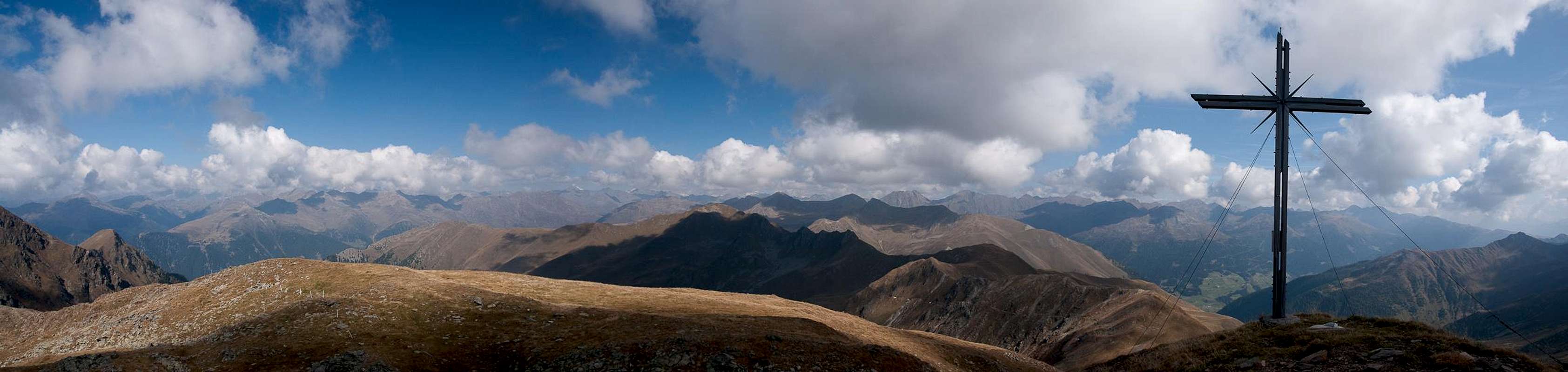
360° Summit Panorama
  |
Getting There
 Central part of the Riepenspitze Group, seen from Rotes Ginggele (by Matthias Zehring) |
The best starting points for an ascent of Gaishörndl / Cornetto di Fana are at Toblach / Dobbiaco in its south or Innervillgraten to its north-east.
- Leave the Brenner Motorway near Brixen / Bressanone and follow SS49 to the east through Pustertal / Val Pusteria.
- At Toblach / Dobbiaco turn northwards for Silverstertal Valley / Valle San Silvestro
- Park your car at the bridge across Silvesterbach Creek
- For Innervillgraten pass Toblach / Dobbiaco and Innichen / San Candido
- Cross the Austrian border on B100
- At Sillian turn north in towards Außervillgraten, Innervillgraten and Kalkstein.
- From Kitzbühel over B108 through the Felbertauern Tunnel to Lienz
- Then southeast to Oberdrauburg (B110)
- Turn on to B100 west into Pustertal.
- Go through the city of Lienz until you get to Sillian.
- There turn north to Außervillgraten, Innervillgraten and Kalkstein.
- For Toblach / Dobbiaco stay on B100 / SS49. Later turn right for Silvestertal.
- From Salzburg along motorway A10 to Spittal.
- Turn west on B100 to Oberdrauburg, Lienz and Sillian (and Toblach / Dobbiaco).
Red Tape
 |
Accommodation
Weather Conditions
Maps & Books
Maps
- Sextener Dolomiten / Dolomiti di Sesto
1:50000
Kompass Map WK58
Kompass Verlag
ISBN: 3-87051-065-X
- Bruneck - Toblach / Brunico - Dobbiaco
1:50000
Kompass Map WK57
Kompass Verlag
ISBN: 3-85491-064-9
Books
- Osttirol Süd / Tirolo Orientale Sud
W. Mair
Rother Verlag
ISBN: 3-7633-4132-3
ISBN: 3-7633-4307-5 (Italian)
- Pustertal
E. Hülsler, M. Kostner
Kompass Verlag
ISBN: 978-3-85026-015-2
- Rother-Skifuehrer "Pustertal"
Rudolf and Sigrun Weiss
Rother Verlag, 2004
ISBN-3-7633-5911-7