
-
 5279 Hits
-
 82.48% Score
-
 15 Votes
|
|
Mountain/Rock |
|---|---|
|
|
46.79248°N / 12.26504°E |
|
|
Hiking, Skiing |
|
|
Summer, Fall, Winter |
|
|
8606 ft / 2623 m |
|
|
Overview
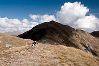
 Hochhorn / Corno Alto seen from the east during the traverse from Gaishörndl / Cornetto Fana Hochhorn / Corno Alto seen from the east during the traverse from Gaishörndl / Cornetto Fana |
It has already been mentioned elsewhere that the Villgraten Group of Hohe Tauern is among the most panoramic ranges in this eastern part of the Eastern Alps. In particular the Riepenspitze Group, a long ridge running south from its namesake summit, is famous for its lookout peaks, mainly the ones along its southern outskirts, around Toblacher Pfannhorn / Corno Fana, it's principal summit. The most popular mountains lie to the east of the Pfannhorn, thanks to their easy access from the northern, Austrian side. Here, on a fine day in summer you can witness a veritable hikers' stampede.
To the east of the main summit, however, several side ridges leave the Riepenspitze Group Main Ridge. They are on Italian ground as the Austrian-Italian border follows the ridge for its entirety. The southernmost of these side ridges, which turns off the main ridge at , Gaishörndl / Cornetto di Fana rivals its eastern counterpart but is much less crowded. Main reason is the long access from the South Tyrolean valleys - you have to scale 1500m of altitude - and the even longer ascent (in terms of distance, not elevation) from Innervillgraten in Austria. The highest of the summits on this ridge is Hochhorn / Corno Alto.
 |  |  |
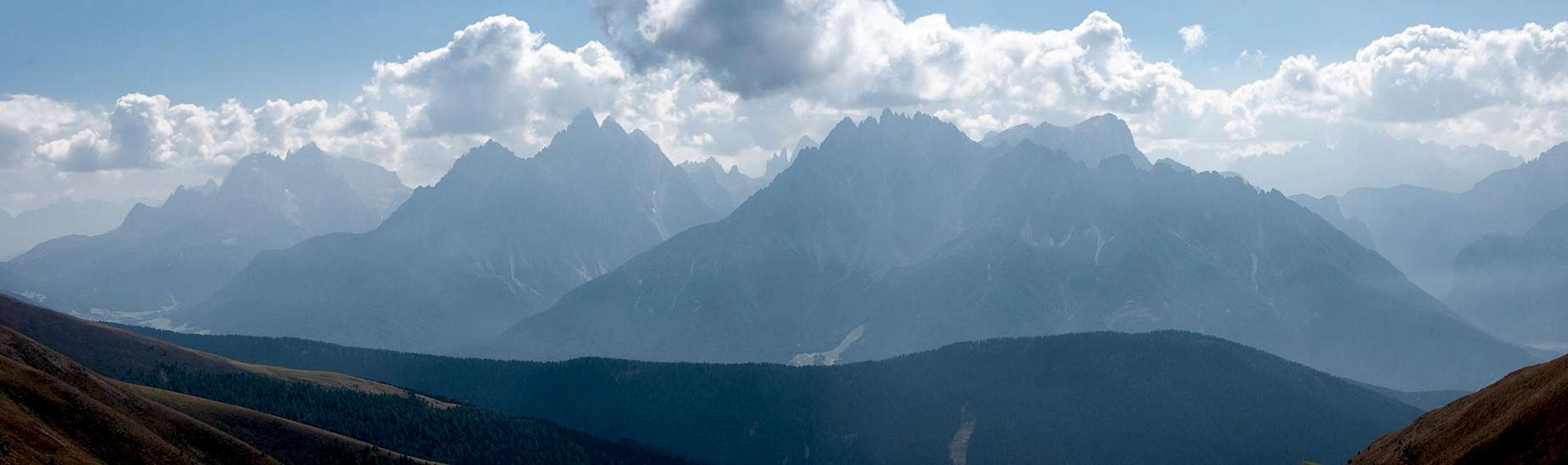
Hochhorn / Corno Alto is a grass covered mountain, with few rock outcroppings close to the summit. At 2623m it is only 50m short of Toblacher Pfannhorn / Corno Fana and thus as excellent a lookout peak. The Vista includes the whole Hohe Tauern Group as well as all the northern Dolomites plus the Carnic Alps Main Ridge. Most spectacular are the views towards the Sexten / Sesto and Prags / Braies Dolomites in the south. However, you need a very early start for good lighting conditions. Also a summer sunset must be gorgeous.
  |
The mountain is usually climbed by either of two routes. Both start at Kandellen near Toblach / Dobbiaco but use different ridges to reach the top. The eastern one of these routes follows the ascent to Toblacher Pfannhorn / Corno Fana, before passing the mountain as well as Gaishörndl / Cornetto Fana on their western sides. The western approach follows the Roßzogel / Monte Cavallo - Golfen / Monte Calvo - Hochhorn / Corno Alto Ridge. Both routes are easy hiking routes and can as easily done in winter as ski tours.
 |  |  |
The town of Toblach / Dobbiaco in recent years has established a hiking / trekking trail: Toblacher Höhenweg. All of the abovementioned mountains are touched by the trail, among them Hochhorn / Corno Alto. For a full hike of Toblacher Höhenweg you will need two days with an overnight stay at Bonner Hütte, also called Pfannhornhütte / Rifugio Corno Fana. In any case you should never climb the mountains without visiting its closest neighbours. With some stamina you'll be able to stand on five summits during a long day!
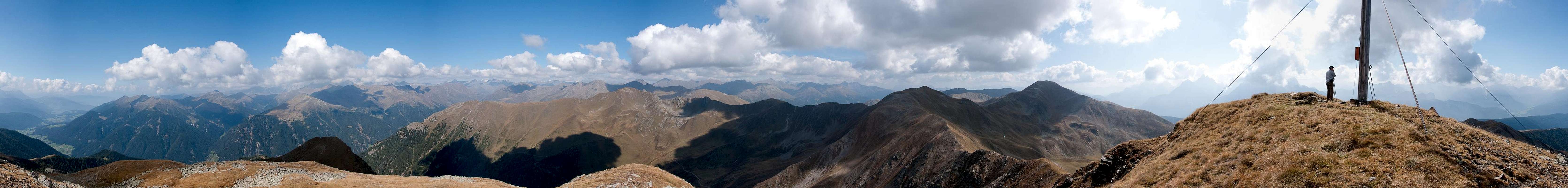
360° Summit Panorama
 |
Getting There
 Central part of the Riepenspitze Group, seen from Rotes Ginggele (by Matthias Zehring) |
The best starting points for an ascent of Hochhorn / Corno Alto are at Toblach / Dobbiaco in its south or Innervillgraten to its north-east.
- Leave the Brenner Motorway near Brixen / Bressanone and follow SS49 to the east through Pustertal / Val Pusteria.
- At Toblach / Dobbiaco turn northwards for Silverstertal Valley / Valle San Silvestro
- Park your car at the bridge across Silvesterbach Creek
- For Innervillgraten pass Toblach / Dobbiaco and Innichen / San Candido
- Cross the Austrian border on B100
- At Sillian turn north in towards Außervillgraten, Innervillgraten and Kalkstein.
- From Kitzbühel over B108 through the Felbertauern Tunnel to Lienz
- Then southeast to Oberdrauburg (B110)
- Turn on to B100 west into Pustertal.
- Go through the city of Lienz until you get to Sillian.
- There turn north to Außervillgraten, Innervillgraten and Kalkstein.
- For Toblach / Dobbiaco stay on B100 / SS49. Later turn right for Silvestertal.
- From Salzburg along motorway A10 to Spittal.
- Turn west on B100 to Oberdrauburg, Lienz and Sillian (and Toblach / Dobbiaco).
Red Tape
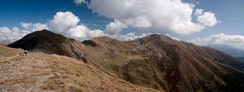 Hochhorn / Corno Alto, Gaishörndl / Cornetto Fana and Toblacher Pfannhorn / Corno Fana
 Accommodation
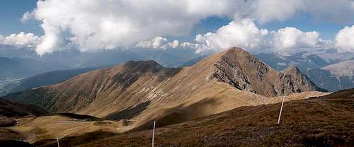 Golfen / Monte Calvo and Hochhorn / Corno Alto
Weather Conditions
Maps & Books
Maps
- Sextener Dolomiten / Dolomiti di Sesto
1:50000
Kompass Map WK58
Kompass Verlag
ISBN: 3-87051-065-X
- Bruneck - Toblach / Brunico - Dobbiaco
1:50000
Kompass Map WK57
Kompass Verlag
ISBN: 3-85491-064-9
Books
- Osttirol Süd / Tirolo Orientale Sud
W. Mair
Rother Verlag
ISBN: 3-7633-4132-3
ISBN: 3-7633-4307-5 (Italian)
- Pustertal
E. Hülsler, M. Kostner
Kompass Verlag
ISBN: 978-3-85026-015-2
- Rother-Skifuehrer "Pustertal"
Rudolf and Sigrun Weiss
Rother Verlag, 2004
ISBN-3-7633-5911-7