
-
 6830 Hits
-
 83.69% Score
-
 17 Votes
|
|
Mountain/Rock |
|---|---|
|
|
49.18139°N / 20.13028°E |
|
|
Trad Climbing, Scrambling |
|
|
6844 ft / 2086 m |
|
|
Intro
Hruba Veza, Hruba Turnia, Dicker Turm, Vastagtorony 2086 The most impressive of High Tatra nunatak crags culminating in a sharp ridge separating Svistova and Litvorova valleys, eastern branches of Bielovodska valley system. Hruba Veza ridge above Bielovodska Valley(on the right)
The deep pass of Litvorova Prehyba separates the massif via extensive postglacial plateau from Velicky Stit peak located in the main Tatra ridge rising here towards highest Tatra peaks of Zadny Gerlach(2640) and Gerlach(2654). There are no marked tourist trails leading to Hruba Veza summit that is accessible for equppied climbers only.
The most interesting challenge for climbers is its south face falling 200 meters down to Litvorova valley. Hruba Veza summit is an absolutely great viewpoint to the whole monumental surrounding of peaks dominating above Bielovodska valley's highest floors, but in regard of its distant location to places where one can stay overnight and hard access via easiest summit route, it is being climbed less than occassionally. The name of the peak comes from its massive shape. First ascent: 17.07.1906 - Zygmunt Klemensiewicz, Roman Kordys and Jerzy Maslanka First winter ascent: 1.02.1926 - Zofia Krokowska, Jerzy Krokowski and Marian Sokolowski
Hruba Veza (2086)
Hruba Veza is a peak in a NW lateral ridge branching from the main Tatra ridge in Velicky Stit peak(arguable issue)and separated to the one with pass of Litovorova Prehyba. The sharp looking crag is double-summited and its SE summit is considered as the main one, higher to less prominent NW one and rises 2086 meters asl. Towards NW direction the peak sends long ridge where some less prominent formations are located.
In Hruby Rog(PL) point the ridge branches to the South and SW directly above Bielovodska valley.
 Hruba Veza from Vychodna Vysoka by Gorzi
Getting There
 Towards Hruba from Tazka valley
Routes Overview
There are no marked trails to Hruba Veza summit, the only marked tourist route, the blue one, cross the foothills of the massif along neighbouring Litvorova valley, leading from Lysa Polana through Bielovodska valley to Prielom Pass with green branching to the nearby pass of Polsky Hreben. Alpine climbing in the area can be practiced in compliance with National Park rules. The easiest of summit routes on Hruba Veza is the short one that led three Polish climbers to conquer the virgin peak in 1906, so that's the name of the crucial formation on it Komin Kordysa(Kordys's Chimney) which commemorates one of these brave people: Roman Kordys. The difficulty of the route is estimated at UIAA I, however due to serious exposition and configuration of rocky terrain the climb should be undertaken with full equipment.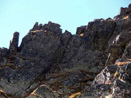 Komin Kordysa
Hruba Veza - Map
 Tatry Wysokie (High Tatra) map, in scale 1:25 000, description in 6 languages, ISBN 83-87873-26-8, available in all shops and book stores in Zakopane . Here you can check the net version
Tatra Maps (English version)
Tatry Wysokie (High Tatra) map, in scale 1:25 000, description in 6 languages, ISBN 83-87873-26-8, available in all shops and book stores in Zakopane . Here you can check the net version
Tatra Maps (English version) Red Tape
It is Tatra National Park(TANAP) area, there are no entry fees but You can hike using only marked trails. Watch out for strict rules of wildlife conservation. Stay always respectful to mountain nature ! From 1.11 to 15.06 year by year all marked routes in TANAP(the whole Slovak side of Tatras) are being closed for tourists (besides the routes leading to mountain chalets). On 21.12.2007 Slovakia along with Poland signed Schengen Agreement and accessed to "open borders" Schengen Area,however one must remember that National Park regulations prohibiting crossing the border beside marked trails in the whole area remain in force.
When To Climb
Best time for climbing/hiking : August – October. June/July : frequent t-storms ,heavy rainfall periods and foggy weather. Planning visiting Tatra Mountains in winter, don't forget to check actual HZS avalanche forecast Hruba Veza at summer storm
Mountain Conditions
Severe and extremely changeable high mountain climate …be always prepared for sudden weather breakdowns ! Rescue Phone Number : 18 300 Horska Sluzba - Tatra Mountain RescueNunataks in High Tatras
Long time has passed since the last High Tatra glaciers disappered leaving the mountain area totally transformed. The main type of landscape that we meet there today is postglacial mountain relief with all its characteristic forms like U-shape valleys, moraines, huge fields of loose rocks and many many others. One of the most interesting remnants after the glacial era in the mountains are former Nunataks. A nunatak (from Inuit nunataq) is an exposed, often rocky element of a ridge, mountain, or peak not covered with ice or snow within (or at the edge of) an ice fieldor glacier. The term is typically used in areas where a permanent ice sheet is present. Nunataks present readily identifiable landmark reference points in glaciers or ice caps and are often named. Nunataks are generally angular and jagged because of freeze-thaw weathering, and can be seen to contrast strongly with the softer contours of the glacially eroded land below if the glacier retreats. As the encyclopedic definition states further the word is of Greenlandic origin and has been used in western European languages since the 1870s. In High Tatras there remained at least a few former Nunataks that stand nowadays as picturesque, isolated crags in the middle of the valleys.
These are for example Strelecka Veza in Velka Studena valley, famous Kostolik crag high in Batizovska valley and Hruba Veza presented here
as the most massive and impressive nunatak crag of Tatra mountains.
 Strelecka Veza
 Kostolik by EQUUS
Camping
Lots of accomodation possibilities of different standard and price on both sides of Tatra Mountains. The nearest place on the north side of the mountains where You can find a room to rent is a village of Tatranska Javorina (4 km by the road from the border in Lysa Polana) but the local choice of accomodation offer is very narrow, just a few private houses and one, expensive hotel. Hotel Kolowrat - Tatranska Javorina The nearest mountain chalets in the area are Zbojnicka Chata and Sliezsky Dom, both on the southern side of the main Tatra ridge. In summer months, there is a camping place, deep in Bielovodska valley, at Polana pod Vysokou open.Planning to camp there, one should be a member of a mountain club and pay the fee for staying there in the woodsman house at the entry to the valley first. Camping in Tatra National Park beside a few designated places is strictly forbidden!