
|
|
Mountain/Rock |
|---|---|
|
|
49.13000°N / 20.01600°E |
|
|
7975 ft / 2431 m |
|
|
Overview
Page is still constructed!
Hrubý Vrch /Hruby Wierch is the one of the most outstanding summit in the longest lateral High Tatra’ ridge, which detaches from the main ridge of Tatra Mountains on Čubrina / Cubryna and culminates in Kriváň / Krywań. It itself is a connecting summit for a lateral ridge with Furkotský Štit / Furkot and Vel’ké Solisko / Wielkie Solisko.
It ascends over Hlinská / Hlińska Valey (in the north direction), Mlynická / Młynicka Valley (south-east) and Nefcerka / Niefcyrka Valley (south-west). In the east direction it is separated from Štrbský Štit / Szczyrbski Szczyt by Štrbské Sedlo / Szczyrbska Przełęcz, in the south Hrubý Vrch connects with Furkotský Štit / Furkot by a fragment of an almost horizontal edge without a distinct pass and in the north-west direction a rocky wall of Hrubé / Grań Hrubego starts.

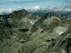
Hrubý Vrch from Liptovske Hole (april 2004)
Hrubý Vrch is easily accessible for hikers and with pleasure visited by them for a beautiful panorama, especially of Kriváň and its surroundings. For climbers the ridge of Hrubé is interesting. The summit was visited first by huters (in XIX centure) and next after “discovering” Tatra Mountains for tourism in the turn of XIX and XX century, they guided tourists there. In winter Guyla Hefty, Tibold Kregczy, Endre Maurer and Lajos Rokfalusy reached the summit as the first in 1912 year.
The Slovakian and Polish name comes from highlanders’ dialect and means “huge summit” and this from a mountain’s shape.
 |  |  |  |  |
Getting There
FROM SLOVAKIAN SIDE:
The major city in this area is Poprad, where you can get by bus or train. From Poprad there is a lot of buses and trains to Starý Smokovec (13km) at the foot of Tatra:
train time table
bus time table
train time table from Poprad to Starý Smokovec Tatranská elektrická železnica
Maps of Štrbské Pleso, Starý Smokovec and Tatranská Lomnica
From Starý Smokovec take a bus (time table) or train (more recommended) (Tatranská elektrická železnica) Štrbské Pleso.
FROM POLISH SIDE:
The best point to stars the journey is Zakopane – the biggest town on Polish side of Tatra Mountains. You can get there from Kraków by bus (most recommended), car or train:
By bus: there are a lot of buses from Kraków to Zakopane - time table of PKS and private lines Frey and Szwagropol.
By train: the road is much longer and dearer than by bus - time table from Kraków 0.00-11.59 a.m., 12.00-11.59 p.m. and from Zakopane.
By car: from Kraków take a road number 7 to Chyżne and follow it to Rabka. Here this road turn right to Chyżne, but you follow still straight a head in south direction by road number 95. In Poronin 5 km before Zakopane turn left (east) to border crossing point in Łysa Polana.
From Zakopane: Take a bus to Polana Palenica (time table of PKS, in high season there are a lot of private buses, too – a station is opposite to PKS) and get off in Łysa Polana / Lysá Pol’ana (Attention! private buses sometimes has a direction-board “Morskie Oko”). Cross the polish-slovakian border . Bus station on Slovakian side is about 100m after border crossing point on the right. Take a bus to Poprad, which goes through Starý Smokovec (time table).
From Starý Smokovec take a bus (time table) or train (more recommended) (Tatranská elektrická železnica) Štrbské Pleso.
Maps

Map of Hrubý Vrch’ area
Tatry Wysokie, in scale 1:25 000, description in 6 languages, ISBN 83-87873-26-8, available in all shops in Zakopane. Here you can look at net version.
A high quality maps in scales 1:25 000 and 1:50 000 are produced VKU Harmanec, too. They are available at all chalets and shops in cities under Vysoke Tatry.
When To Climb
The best time is a summer and early autumn (June - October), but Hrubý Vrch is available the whole year.
Red Tape
The “High Tatra” is a National park, UN Bioheritage area and a European BioHeritage - if you are not a member of any climbing club you can move only on marked trails - so you can visit Hrubý Vrch only with Tatra guide.
In winter time (from November the 1st – June the 15th) The Tatra Mountains in Slovakian part are closed for normal tourists (not for climbers). In Polish part you can move the whole of year.
For more informations look at High Tatra/Vysoke Tatry GROUP page.
For climbing regulations look at Gerlachovsky Stit page.
Accommodation
There is only one chalet near by Hrubý Vrch:
Chata pod Soliskom - situated not far from Štrbské Pleso on the Predné Solisko’ south slope. Chalet is opened all the year for hiking, climbing and ski mountaineering.
Access from:
1. Štrbské Pleso - via blue-marked trail (2 h)
2. Štrbské Pleso - via red/yellow/blue-marked trails (2 h)
3. Štrbské Pleso – by chairlift (phone: +421-52-4492343, e-mail: info@parksnow.sk, price)
Contact:
phone: +421 905 652 036, +421 907 949 442
e-mail: info@chatasolisko.sk
Absolutely no camping is permitted in the nature park. The nearest camping in Slovakian side is in Stara Lesna and Tatranska Lomnica.
There are plenty of cheap hotels and pensions in the area of Stary Smokovec and Štrbské Pleso: accommodation
Mountain Conditions
Web forecast:
situation at this moment and forecast
Information of avalanche danger:
TOPR (in English) and HZS
Rescue:
On Slovakian side acts HZS (Horska Zachranna Sluzba)
Starý Smokovec 23, 059 60 Vysoké Tatry
phon.: 052/4422820, fax: 052/4422855,
mobil: 0903624869
e-mail: vtatry@hzs.sk