Overview
Hum (587m) is the highest peak on the island of Vis. Unfortunately leadership to top is not available because there is the military facility which should not be approached. Control point of HPO (Croatian mountineering tour) is the Chapel of Saint Spirit in the vicinity.
![Hum - chapel of Saint Spirit]() Hum - chapel Sveti duh
Hum - chapel Sveti duhGetting There
Vis, Biševo, Svetac(Saint), Brusnik, Jabuka(Apple) and Palagruža make the outmost, pelagic, string of the middle Adriatic islands.
http://www.jadrolinija.hr/pdfs/602.2011.zima.e.pdf
http://www.jadrolinija.hr/pdfs/602.2011.zima.e.pdf
http://www.jadrolinija.hr/pdfs/9602.2011.zima.e.pdf
http://www.jadrolinija.hr/pdfs/9602.2011.ljeto.e.pdf
http://www.info-vis.net/engleski/eng-bus.htm
![Location of Vis]() location of island Vis
location of island Vis![nautic map Svetac Bisevo Vis]() nautic map Svetac Biševo Vis
nautic map Svetac Biševo Vis![shematic map of island Vis]() shematic map of islands Vis and Biševo
shematic map of islands Vis and Biševo![map of island Vis]() map of island Vis 1
map of island Vis 1![map of island Vis 2]() map of island Vis 2
map of island Vis 2Red Tape
No limitation.
Mountain house and camping
Mountain house Svet Andrija (St. Andrew) (267 m) is located exactly at the top that dominates the redundant port of Vis. It is a former military facilities for hiking needs of members arranged by HPD Hum from Vis. The house has a range of drinks, and there is a possibility of overnight stays.
INFO
Open: negotiable
Stocked: drink
Places to Bed: 14
Manages: HPD Hum, Vis
Information: Željko Arnautović
tel.: 098/98-03-330, 021/711-487, 021/711-736
Access to the vehicle leads to the house poor dirt road that is not recommended for driving, so that Vis is also the nearest place until it can reach the vehicle.
Time of ascent: Vis - mountain house St Andrew 1:30 h
![mountain haus Saint Andrew]() mountain house Sveti Andrija
mountain house Sveti Andrija![view on Vis from Saint Andrew]() view on Vis from mountain house Sveti Andrija
view on Vis from mountain house Sveti Andrija![military tunnel in Vis bay]() military tunnel in Vis bay
military tunnel in Vis bay![Vis by night]() Vis 1
Vis 1![Vis 1]() Vis 2
Vis 2![Vis 2]() Vis 3
Vis 3View
From the chapel of St. Spirit you can see Komiža, islands Svetac(Saint) and Biševo and cliff Jabuka(Apple).
![view on Komiza from Hum]() view on Komiža from chapel Sveti Duh
view on Komiža from chapel Sveti Duh![Komiza 1]() Komiža
Komiža![panorama of Komiza and Hum]() panorama of Komiža and Hum
panorama of Komiža and HumCoordinates
N 43 ° 2 '7.9''E 16 ° 6' 55.1''
Mark
Metal stamp is built into the right door of the chapel of St. Spirit.
Approaches
Podašpilje - Woman head (Žena glava) - Tito's cave - St. Spirit on Hum 1:25 h
Komiža - St. Spirit on Hum 2:00 h
Vis - Woman head - Tito's cave - St. Spirit on Hum 3:30 h
By Hum you can easily get asf. road from the village Žena glava (Woman head). In addition to the markings leading to the chapel of St. Spirit to Podašpilje, Vis and Komiža by almost all the island's roads were carried out hiking markings that provide countless hiking opportunities.
Maps and guides
Torist and trekking map Vis island - Croatian Mountain Rescue Service (HGSS)
Tourist-mountaineering guidebook - Croatian Mountain Rescue Service (HGSS)
GPS
staza: http://free-st.t-com.hr/Ante/gpx/Vis01srpanj2011.kmz
Tito's cave
On the way out Podašpilje valid Vis or visit Tito's cave hidden on the slopes of Hum. These are two small caves undecorated, partially walled in entrance, where Josip Broz Tito and partisan leadership secretly spent several months during the Second World War (1944). To cave there is access road of 275 steps. The caves can be seen without additional lighting.
![Tito s cave 1]() Tito's cave 1
Tito's cave 1![Tito s cave 2]() Tito's cave 2
Tito's cave 2Stiniva bay
Stiniva bay is well known nature monument, whose deeply recessed beach is closed with two high rocky gate leaves, appear impressive cliffs.
![beach Stiniva 1]() Stiniva bay
Stiniva bay![beach Stiniva 2]() beach Stiniva
beach Stiniva![sea passage to beach Stiniva 1]() sea passage to beach Stiniva 1
sea passage to beach Stiniva 1![sea passage to beach Stiniva 2]() sea passage to beach Stiniva 2
sea passage to beach Stiniva 2Blue cave (Modra špilja) on the island of Biševo
Blue cave(Modra špilja) on the island of Biševo is protected by law as nature monument. There occurs rare phenomenon when about noon, on calm sea days, the sunshine enters through its natural opening, reflect from the white bottom and illuminate the cave walls with blue, and object in the sea with silverfish light.
![Blue cave on island Bisevo 1]() Blue cave on the island of Biševo 1
Blue cave on the island of Biševo 1![Blue cave on island Bisevo 2]() Blue cave on the island of Biševo 2
Blue cave on the island of Biševo 2Green cave(Zelena špilja) on the island of Ravnik
The islet of Ravnik, protected as significant landscape, hides at its southern part an unusual cave with two exits towards the sea and one opening in the ceiling. The sunshine rays that enter the cave create a magic green-light effect after whic the cave has been named-Green cave(Zelena špilja). Green cave is a geomorphplogic monument of nature and genuine attraction for divers and tourists.
![Green cave on Ravnik]() Green cave on the island of Ravnik 1
Green cave on the island of Ravnik 1![Green cave on Ravnik 2]() Green cave on the island of Ravnik 2
Green cave on the island of Ravnik 2![Green cave on Ravnik 3]() Green cave on the island of ravnik 3
Green cave on the island of ravnik 3External Links
Add External Links text here.

 Hum - chapel Sveti duh
 location of island Vis
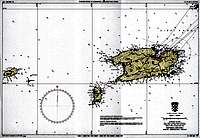 nautic map Svetac Biševo Vis
 shematic map of islands Vis and Biševo
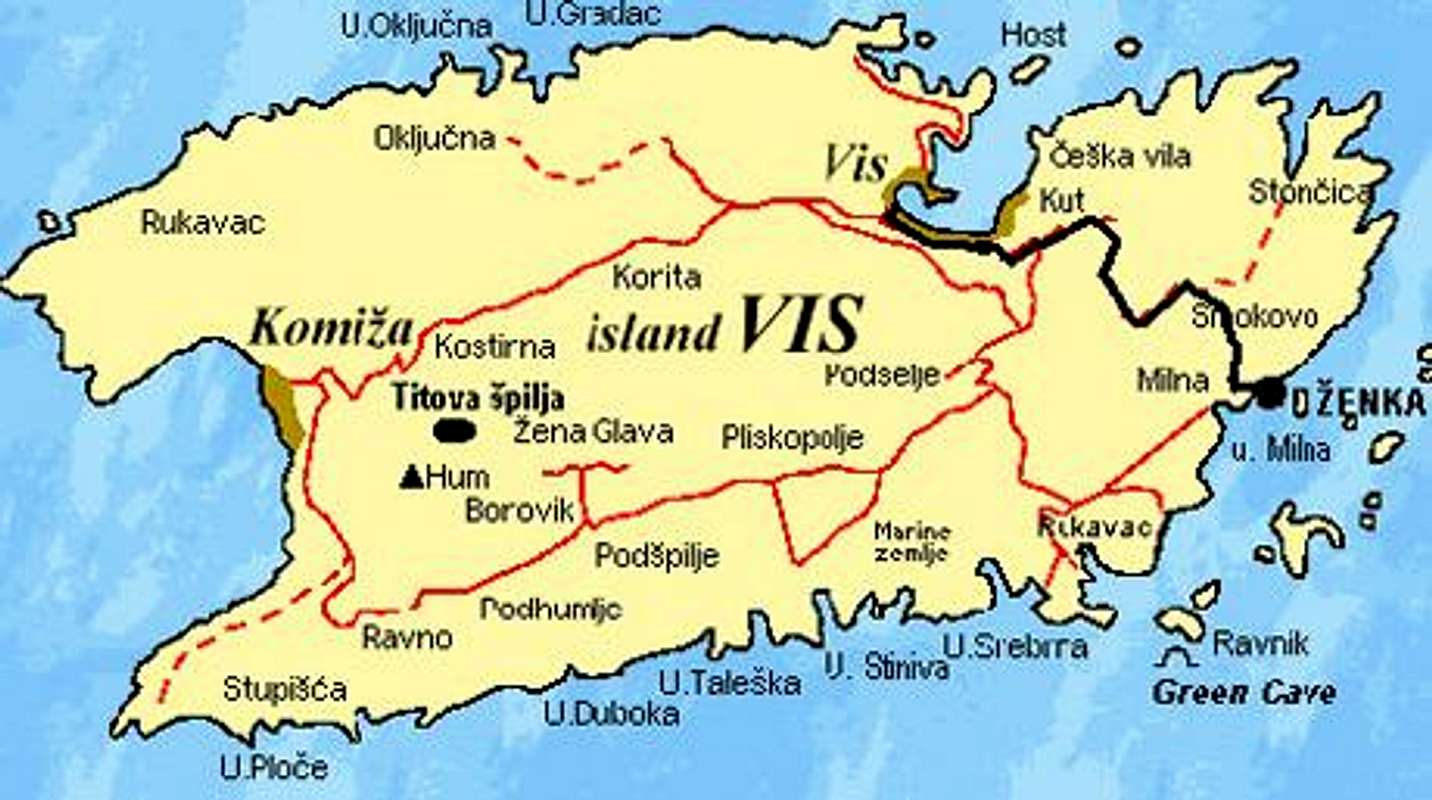 map of island Vis 1
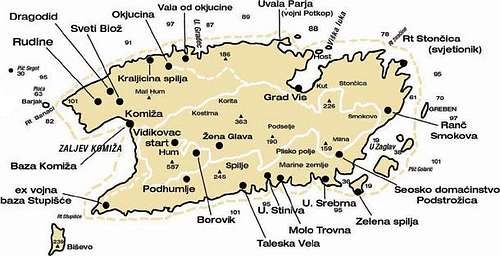 map of island Vis 2
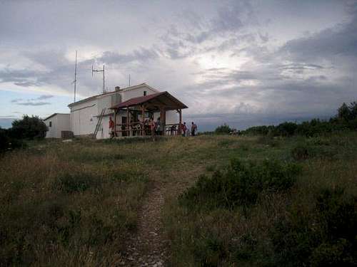 mountain house Sveti Andrija
 view on Vis from mountain house Sveti Andrija
 military tunnel in Vis bay
 Vis 1
Vis 1 Vis 2
Vis 2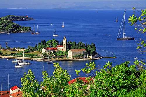 Vis 3
Vis 3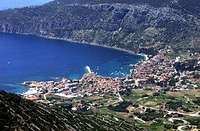 view on Komiža from chapel Sveti Duh
 Komiža
 panorama of Komiža and Hum
 Tito's cave 1
 Tito's cave 2
 Stiniva bay
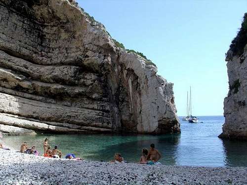 beach Stiniva
 sea passage to beach Stiniva 1
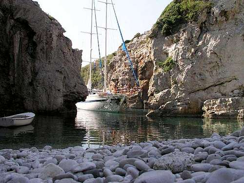 sea passage to beach Stiniva 2
 Blue cave on the island of Biševo 1
 Blue cave on the island of Biševo 2
 Green cave on the island of Ravnik 1
 Green cave on the island of Ravnik 2
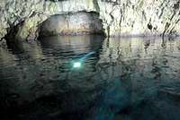 Green cave on the island of ravnik 3