
-
 28288 Hits
-
 94.02% Score
-
 45 Votes
|
|
Area/Range |
|---|---|
|
|
27.96000°N / 15.84°W |
|
|
Hiking, Mountaineering, Sport Climbing, Canyoneering |
|
|
Spring, Summer, Fall, Winter |
|
|
12199 ft / 3718 m |
|
|
Overview
 Teide seen from Pico Viejo Teide seen from Pico Viejo |
The Islas Canarias, Canary Islands, Islands of Everlasting Spring are Europe’s version of the Hawaiian Islands in the Pacific – a holiday getaway with guaranteed good weather and a great abundance of beautiful beaches all at a distance of about 4-5 flight hours from any European International airport. While most visitors stay at or near the beaches the Islands have more to offer than sun, sand and sport. All islands are of volcanic origin and many volcanoes have been active quite (geologically speaking) recently. The last eruption occurred on Volcàn Teneguìa on La Palma in 1971. The Canarias are home to Spain highest mountain, Pico del Teide, the world’s largest erosion crater, Caldera de Taburiente, impressive volcanic plugs like Roque Bentayga or the desert-like Parque Nacional de Timanfaya on Lanzarote.
There are seven large islands (and six smaller ones) which can be divided in two groups. The easertn islands of Lanzarote, Fuerteventura and Gran Canaria were formed about 25 – 15 million years ago while the four western islands Tenerife, La Gomera, La Palma and El Hierro were formed much more recently – and are volcanically much more active still. Politically, the Spanish government has divided the Canarias along the same lines with the Province of Las Palmas (de Gran Canaria) governing the eastern islands while the province of Santa Cruz (de Fenerife) governs the western ones.
  |
The Islas Canarias are located close to the African mainland but have politically always been considered a part of Europe. In fact – before Amarica got discovered El Hierro was the westernmost known spot on earth which resulted in the zero meridian being located there, exactly 20° west of Paris. Many of the European governments still used this meridian until the 1990ies. The ocean floor beneath the islands is down to 3500m deep making the straights between the islands some of the deepest on earth. Moreover the true altitude of the volcanoes gets even more impressive if you count their elevation from the ocean floor. The islands are considered as leftovers of the continental drift when South America and Africa drifted apart.
Today the main industry on most of the islands is tourism, together with agriculture (mostly banana monocultures). The large islands have fallen victim to the usual excesses – large concrete tourist hotels around the beaches while the three smaller western islands of El Hierro, La Gomera and La Palma are relatively untarnished yet. The main season on the Canarias is in winter, when northern and central Europeans flee snow and fog to bake a bit in the sun. Still the hotels on the islands are busy all year around.
The Islas Canarias on SP
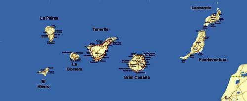 Overview Map Islas Canarias
- Lanzarote introduction (this page)
Lanzarote (separate page) - Fuerteventura introduction (this page)
Fuerteventura (separate page) - Gran Canaria introduction (this page)
Gran Canaria (separate page) - Tenerife introduction (this page)
Tenerife (separate page) - La Gomera introduction (this page)
La Gomera (separate page) - La Palma introduction (this page)
La Palma (separate page) - El Hierro
1 - Lanzarote
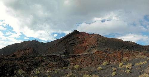
Coordinates: 29.03N / 13.63W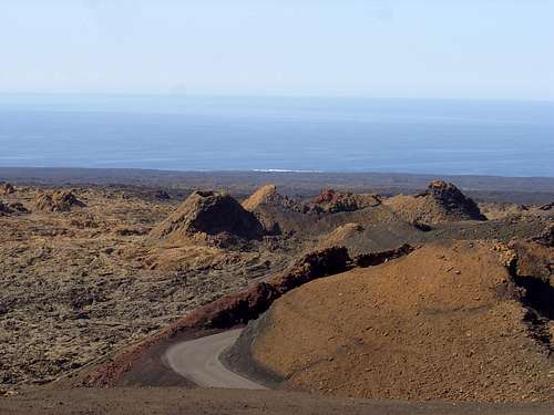 The area of Montañas del Fuego (Mountains of fire) in the natural park of Timanfaya
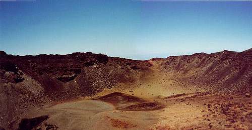
Lanzarote (850 square km) is the north-easternmost of the Islas Canarias and as such only 140km away from the Moroccan mainland. It is also one of the oldest of the islands being formed 19 miliion years ago by volcanic activity. Since then much of the island has eroded again. Lanzarote therefore is the lowest of the Canaries with tow mountainous regions, Famara (671m) in the north and Los Ajaches (608m) in the south. Between both regions you find Parque Nacional de Timanfaya and the Parque Natural de los Volcanes, two parks which cover the area of the most recent eruptions on Lanzarote.
Between 1731 and 1736, for five years hundreds of craters erupted and covered 147 square kilometres – today’s national parks – with lava, cinder and scree. Much of the agricultural areas were covered, forcing the inhabitants to emigrate to others of the Canarian Islands. 8 million cubic meters of cinder and lava were deposited during that eruption. The center of the eruption was Maciso del Fuego in the center of the parks, a 525m high cinder cone. Even today the area within the parks is active – the earth’s crust is just about 2m thick with temperatures of up to 400° C underneath. Park rangers like to demonstrate this by pouring water down a metal tube which evaporates explosively.
Lanzarote can be easily reached by charter jet from any European airport. The island has an international airport near Arricife, its capital, on the eastern coast. Most of the tourist beaches are located there too. Thanks to the lack of elevation Lanzarote gets only very few drops of rain which makes water one of the most looked after commodity of the island. It is either shipped by tanker from the other Canarian Islands or produced by a saltwater conversion plant in the north of the island. Tourists consume about five times the amount of water than the inhabitants of the island.
Lanzarote is surrounded by a number of smaller volcanic islands – see the section below for more information.
2 - Fuerteventura
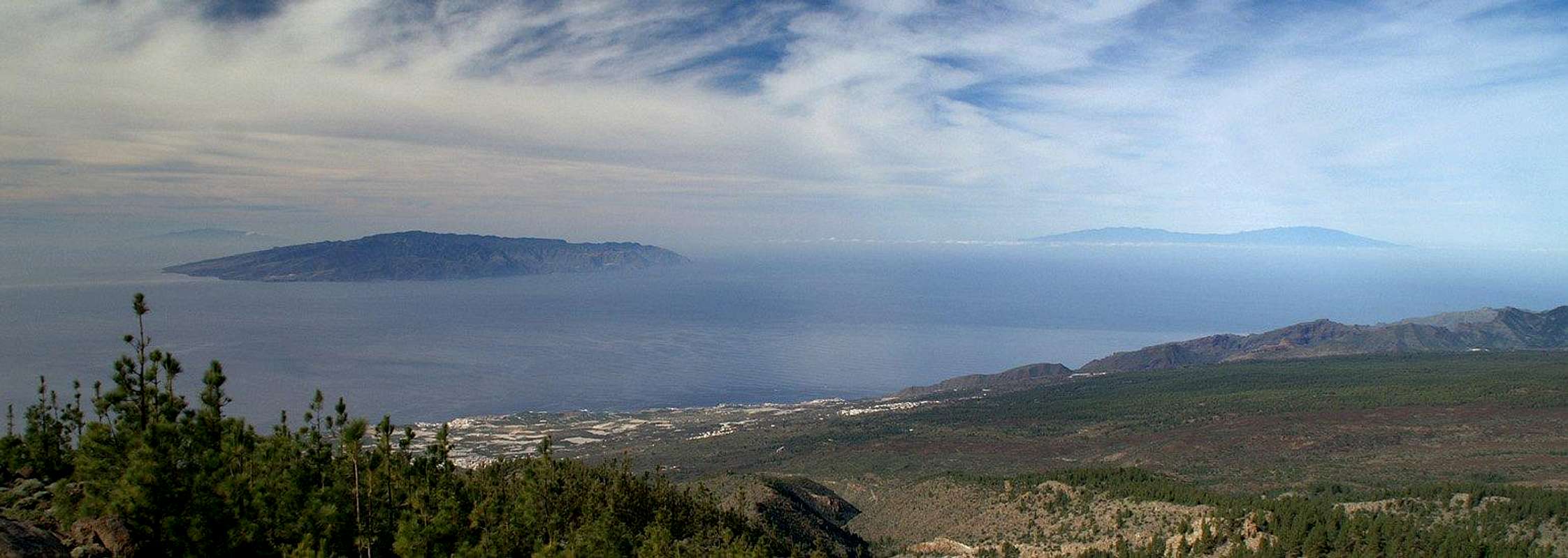
Coordinates: 28.35N / 14.03W Fuerteventura seen from Punta del Papagayo on Lanzarote
With 1660 square km Fuerteventura is the second largest of the Islas Canarias and the oldest. It was formed 20 million years ago with the bulk of the material created 5 million years ago however. The last eruptions occurred 4000 – 5000 years ago. Its highest point is Pico de Jandía (807m) on the equally named peninsula in the south of the island.
Fuerteventura is mainly known for its beaches on the east coast and is actually one of the main tourist islands of the Canaries. You find massive wandering sand dunes near Corralejo to the north east of the island, easily demonstrating the proximity to the Moroccan Sahara across the sea to the east.
The island has an international airport south of its capital Puerto del Rosario on the east coast. Numerous charter lines touch down there at all times of the year.
3 - Gran Canaria
Coordinates: 27.93N / 15.43W Roque San Jose, El Fraile (The Friar) and Roque Nublo
With roughly 1500 square km Gran Canaria is the third largest of the Islas Canarias. It is an almost perfectly shaped circle, clearly indicating its volcanic origin of 15 million years ago. However, though volcanism is present everywhere on the island, there have been no recent outbreaks, which makes Gran Canaria a much greener island than either Lanzarote or Fuerteventura. Moreover Gran Canaria reaches an elevation of 1951 in Pico de las Nieves which impedes the north-easterly trade winds which generally sweep right over the lower islands. By being forced to rise high above the sea level the moisture condenses in heavy clouds which deposits in rain or fog on the northern and eastern sides of the island while leaving the western and southern parts bone dry.
Consequently you can find much more flora on Gran Canaria than on Lanzarote or Fuerteventura like laurel forests in the north. Additionally you’ll find deeply eroded Barrancos (canyons) which have carried much of Gran Canarias substance out to the sea already. Witness to this erosion are the huge erosion craters of Caldera de Tejeda to the east and Caldera de Tirajana to the west of the island. They connect in Gran Canaria’s highpoint, Pico de las Nieves.
Gran Canaria’s landmarks are two volcanic plugs which have withstood the erosion: Roque Nublo and Roque Bentayga. Both are located in or near the large cauldron of Caldera de Tejada and are basalt monoliths. Roque Nublo offers several interesting climbing routes as does the nearby Montaña del Asserador.
While the east and south of the island are touristically developed much of the centre and the north-west are quite lonesome. Most of the interesting hikes can be found in there and there is no need to visit the tourist centers if you came for exploring the island on foot. Gran Canaria’s international airport is located to the far east of the island, far away from the capital Las Palmas de Gran Canaria.
4 - Tenerife
Coordinates: 28.27N / 16.59W Teide , Pico Viejo and Guajara as seen from Volcán Martin on La Palma
Everything that can be said about Gran Canaria can also be said about Tenerife, only far more pronounced. Among the Canarias Tenerife is the island of superlatives. It is the largest island with 2050 square km and the highest. Spain’s highest mountain, Pico del Teide is located right in the centre of the island. The island was created 7 – 5 million years ago when the Teno and Anaga mountainous regions to the north-west and north-east were created. Speaking of regions – a large island like Tenerife may be allowed to have more of them.
- To the far north-east there are the Anaga Mountains, a wild area covered in lots of laurel forests. It offers great hikes from the steep coast to the mountains at almost 1000m
- Still in the north-east of the island, south of Puerto de la Cruz you find the Cumbre Dorsal, a ridge running from south-west to north-east. There are a number of easy hiking trails with great views towards the coasts and towards Teide.
- Las Cañadas del Teide is a giant Caldera, a part of which has been washed away towards the north-west. Located in the center of the island, the most impressive feature is Pico del Teide at its northern rim. The mountains along the rim are the highest ones you can find in all the Canarias. Apart from Teide Pico Viejo needs to be mentioned as well as Guajara on the southern caldera rim. The caldera itself is a huge plain filled with lava, the Llano Ucancos. Huge walls of Lava have been pushed up the most impressive forming the bizarre forms of the Roques de Garcia. In the Cañadas everything shimmers in every conceivable colour!
- To the north-west of the island there is the small region of the Teno mountains. Covered with laurel forests the area is quite remote and lonesome though near the coast you encounter the omnipresent banana plantations. Teno is home to one of the most rugged canyons on earth, the winding Barranco de Masca. Carved out of the volcanic rock by a small creek you rarely get to see the light until you quite suddenly come out onto the small Playa de MAsca at the sea.
 The huge Pico Viejo crater
The whole southern part of Tenerife is dedicated to tourism. Since the trade wind clouds rarely are able to cross the Cañadas you have sunny weather almost at all times. The north of the island is far less touristical though certainly very beautiful (whenever the clouds let you see anything). There are two international airports on Tenerife, one in the south at Los Abrigos, one in the north near the capital Santa Cruz de Tenerife.
5 - La Gomera
Coordinates: 28.11N / 17.24W La Gomera as seen from Volcàn Martin on La Palma
La Gomera is the second smallest of the Islas Canarias reaching 380 square km. It looks like a smaller replica of Gran Canaria, showing the same quasi circular shape a high plateau at its midst and its deep barrancos leading out to the sea. La Gomera is far less touristically used than the larger islands, mainly because large charter jets cannot land on its small airport. Therefore the regular routine to get to the island calls for a switchover at Tenerife with the second leg either by plane or one of the fast ferries (which take only 30min to reach La Gomera).
La Gomera’s highest mountain is Garajonay which reaches an elevation of 1487m. Around the mountain a national park, the Parque Nacional de Garajonay has bee established in 1978. 10% of the island’s area have been set aside for the park which is home to the largest consecutive piece of laurel forest on earth. 50% of all laurel forests on the Canarias can be found here. Like on most other Canarian Islands the 1500m high high plateau serves as weather divide. Wet and foggy in the north and west the weather in the south remains dry and sunny.
La Gomera’s moment in the spotlight came when Christopher Colombus stayed at the island just before he set out to discover America. Today mostly hikers spend teir vacations on the island. The capital is San Sebastian de la Gomera at the south coast
6 - La Palma
Coordinates: 28.68N / 17.85W Montaña Pelada (1441m), Volcán Martín (1597m) and Volcán Cabrito (1864m)
La Palma takes a special place among the Islas Canarias. It is the third smallest island with its 730 square km but the most mountainous one. The highest summit, Roque de los Muchachos reaches 2426m giving the La Palma the highest mass to area ratio of all the islands of the earth. La Palma is the north-westernmost of the Canaries and thanks to the lack of large beaches you will almost only find hikers out there. It is also the island with the most, and most recent volcanic eruptions, the last of which took place at its southern tip creating Volcàn Teneguìa. In all, together with El Hierro, La Palma is the youngest of the Islas Canarias being about 2 million years old.
The Island has three mountain ranges which are all interconnected.
- Caldera de Taburiente is the world’s largest erosion crater at 28km in circumference, 9km in diameter and down to 1500m in vertical drops to the inside of the crater. The caldera has been washed out to the south-west by the Canarias’ only river, Rio de Taburiente. It is home to all 2000ers of the island culminating in Roque de los Muchachos.
- The Cumbre Nueva is the remaining part of a huge and old erosion crater, the bulk of which slid down to the western side of the island in prehistoric times
- The Cumbre Vieja is the southernmost of the ranges, the only one which is stil volcanically active today. More than 100 volcanoes and craters make up the range, which culminates in Volcàn de la Deseada.
 Volcàn Teneguìa as seen from the east
La Palma gained some notoriety after the South Asian tsunami in late 2004. Scientists stepped up to present an old theory which claims that the island of La Palma will be the origin of a huge mega-tsunami sometime in the future. During one of the last eruptions in 1941, when three volcanoes erupted simultaneously, the western part of the range dropped by several meters. Since the rock of Cumbre Vieja is porous a lot of water is supposed to have accumulated in the cavities beneath the surface. Another huge eruption like the 1941 one would evaporate the water explosively to detach the western part of the range altogether. That would tumble into the sea creating huge shockwaves which would travel towards the American continent at almost the speed of sound and devastate all coastal regions from New England to Brazil. When and even if such an event will take place is anybody’s guess. But you might want to take a look at the map of El Hierro (see below), where exactly such an event occurred 15000 years ago, creating the huge circularly shaped Bahia de los Pozos.
La Palma is famous for its two trekking trails, the Ruta de la Cresteria around Caldera de Taburiente and the Ruta de los Volcanes along the ridge of the Cumbre Vieja. The Island has an international airport south of its capital, Santa Cruz de la Palma.
7 - El Hierro
Coordinates: 27.73N / 18.01W El Hierro during sunset from La Gomera
El Hierro is the smallest of the Islas Canarias, covering an area of 290 square km. Nevertheless it reaches a height of 1500m, which gives it an incredible mass to area ratio, much like neighbouring La Palma. Both islands share a lot of history – they are the youngest islands of the Canaries with El Hierro being 3 million years old. The island first developed in the Pliocene when volcanoes erupted along two lines shaping a large Y. Over the years the lines converged and more mass built up until in a second period of activity a large volcano built up where today you find Bahia de los Pozos and El Golfo. For some unknown reason that volcano became unstable slipping into the ocean, probably creating a huge tsunami in its wake. A similar scenario is predicted for the Cumbre Vieja on neighbouring La Palma.
El Hierro’s highest mountain is Pico de Malpaso, reaching 1501m. In general, though quite high for such a small island it is hardly considered being mountainous. The main reason is the large high plateau, which hosts one of the largest agriculturally used areas on the Canarias. There is not much tourism on the island – the local government tends to keep the total number of hotel beds below 2000. There is an airport but – like the one on La Gomera it is too small to cater to large charter jets. Therefore only the local Canarian carrier serves the island.
Formerly El Hierro was the westernmost place in the known world, that is before Christpher Columbus sailed for the Americas. Therefore – for a long time the meridian was located on the island – defined to be located exactly 20° west of Paris the then known centre of the earth. Many systems (e.g. Gauß-Krüger) and countries kept using that definition up to the late 1990ies.
8 - The Small Islands
It has already been mentioned in the overview section that there are several small islands and rocks scattered around the eastern islands of Lanzarote and Fuerteventura. The following table gives an overview:| Name | Area | Highest Mountain | Coordinates | Thumbnail |
| Alegranza | 10.2km² | Montaña de Alegranza (289m) | 29.40 / -13.49 | |
| Graciosa | 27km² | Montaña Bermeja (157m) | 29.25 / -13.51 |  |
| Los Lobos | 6km² | Montaña de Lobos (127m) | 28.75 / -13.82 | |
| Montaña Clara | 1.3km² | Montaña Clara (256m) | 29.30 / -13.53 | |
| Roque del Este | 0.06km² | Roque del Este (84m) | 29.28 / -13.34 | |
| Roque del Oeste | 0.02km² | Roque del Oeste (41m) | 29.31 / -13.53 |
Traffic & Accommodation
As said repeatedly above you can reach the large islands Lanzarote, Fuerteventura, Gran Canaria and Tenerife from almost any major European airport on a daily basis. La Palma is a bit more difficult to get to – the airport is so small that I only can take in a few large aircraft at a time. Moreover you might have to switch planes before you get there.La Gomera and El Hiero can only be reached by a relayed flight schedule or by using one of the ferries from Tenerife or La Palma. For the flight schedules look at the websites of the large charter airlines (e.g. Thomas Cook or Hapag Lloyd).
Almost the same holds true for accommodation on the islands – you can rent hotel rooms and apartments from any travel office in Europe (overseas might be a bit more difficult). Many of the large companies have their own web sites so that you might look them up there as well (for example again the above mentioned companies). For fincas you can try to contact locals from a web based search – many expatriates offer their own houses for use by tourists. It takes a bit of research on the web however.
Local transport is available by bus. There are bus lines on all of the islands which will bring you close to your starting point in anyway. However often a given busstop is only served a couple of times per day. Therefore it pays to get a rental car, especially on the larger of the islands. Obtaining a car is easy, prices are quite high though. If you don't stay at a hotel you'll be sure to get a run down rig for the same price.
Red Tape
 Canarian Pine on La Palma
On almost each of the Canarian Islands there are National or Natural Parks around the points of interest. These parks serve two purposes:
The obvious rules apply - keep animals and plants where they are, don't enter volcanic areas without supervision, etc. However, the rules are applied and enforced quite differently. While the Timanfaya Natural Park on Lanzarote and the summit of Teide on Tenerife can only be visited with guides or permission, the inside of the Caldera de Taburiente on La Palma or the Garajonay Natural Park on La Gomera can be freely visited but are nevertheless supervised regularly by park rangers. The Tamabada mountain range on Gran Canaria on the other side has rather the aspect of a large picnic site.
Park rangers prowl the parks. Depending on the popularity of the parks these guys can be very short fused - which might explain the difference in approach to questions of rule enforcement. On Teide everybody tries to sneak by them to get to the summit and they are clearly sick of it. In La Cumbrecita on La Palma the rangers have to help otherwise clueless tourists to park their cars - and these guy have had it, too.
Never try to camp out where you are not supposed to. While you might get off without a fine you are setting the example of the nasty tourist. Often part of the land in a national park belongs to local farmers or to large estates. And most of the times the next village is less than an hour away.
Weather Conditions
 Trade wnd clouds oozing into the Caldera de Tejeda on Gran Canaria
The Canarian Islands are located in the trade wind zone. You almost always encounter northeastern winds which carry a lot of humid air. Being forced to climb to higher altitudes this moisture condenses into clouds. This in return means that most of the time the northeastern parts of the islands are covered in clouds from altitudes of 1000m through 2000m.
The mountains themselves - being mostly of the same altitude - finally stop the clouds so that on their southeastern slopes the clouds "run out". In the case of Tenerife the Cañadas del Teide are so high that rarely ever do you encounter fog or clouds. For Lanzarote and Fuerteventura on the other hand it means that the foggy clouds sweep over the islands without leaving much rain. Many parts of the islands therefore are arid and desert like.
Also never underestimate the weather on the Canarias. This especially applies to Tenerife and La Palma, the highest islands. Always remember that a hot day near the coast can be freezing cold at 2500m and higher. Moreover the trade winds at higher altitudes are more than fresh - they are regular gales. Many a climber was forced to retreat from mountains like Pico Viejo due to high winds while even at 2000m everything seemed hot and sunny.
Maps & Books
Maps
Kompass has the best (that is complete) selection of maps on the Canarian Islands. However, while I love their maps of the Alps I have had quite a number of bad experiences on the islands. Anyone who knows better maps please step up and let us know.
- Lanzarote
Kompass Map WK241
Kompass Verlag
1:50000
ISBN 3-85491-175-0
- Fuerteventura
Kompass Map WK240
Kompass Verlag
1:50000
ISBN 3-85491-174-2
- Gran Canaria
Kompass Map WK237
Kompass Verlag
1:50000
ISBN 3-85491-114-9
- Teneriffa / Tenerife
Kompass Map WK233
Kompass Verlag
1:50000
ISBN 3-85491-038-X
- La Gomera
Kompass Map WK231
Kompass Verlag
1:30000
ISBN 3-85491-015-0
- La Palma
Kompass Map WK232
Kompass Verlag
1:50000
ISBN 3-85491-029-0
- El Hierro
Kompass Map WK242
Kompass Verlag
1:30000
ISBN 3-85491-194-7
Digital Maps
Kompass is the only company known to me which offers GPS digital Maps. Here is their selection
- Lanzarote
Kompass GPS4241
Kompass Verlag
ISBN 3-85491-223-4
- Fuerteventura
Kompass GPS4240
Kompass Verlag
ISBN 3-85491-222-6
- Gran Canaria
Kompass GPS4237
Kompass Verlag
ISBN 3-85491-219-6
- Teneriffa / Tenerife
Kompass GPS4233
Kompass Verlag
ISBN 3-85491-218-8
- La Gomera
Kompass GPS4231
Kompass Verlag
ISBN 3-85491-425-3
- La Palma
Kompass GPS4232
Kompass Verlag
ISBN 3-85491-217-X
- El Hierro
Kompass GPS4242
Kompass Verlag
ISBN 3-85491-224-2
Books
My recommendation is a set of by Rother Verlag, all available in German, four of them available in English. The books are excellent hiking guides covering all the interesting areas of the islands. Since they come with small maps for each excursion they might even be used without a map to support them.
- Lanzarote
Rolf Goetz
Rother Verlag
ISBN 3-7633-4302-4 (only German)
- Fuerteventura
Rolf Goetz
Rother Verlag
ISBN 3-7633-4303-2 (only German)
- Gran Canaria
Izabella Gawin
Rother Verlag
ISBN 3-7633-4000-9 (German)
ISBN 3-7633-4816-6 (English)
- Teneriffa / Tenerife
Klaus Wolfsperger / Annette Miehle-Wolfsperger
Rother Verlag
ISBN 3-7633-4016-5 (German)
ISBN 3-7633-4809-3 (English)
- La Gomera
Klaus Wolfsperger / Annette Miehle-Wolfsperger
Rother Verlag
ISBN 3-7633-4007-6 (German)
ISBN 3-7633-4823-9 (English)
- La Palma
Klaus Wolfsperger / Annette Miehle-Wolfsperger
Rother Verlag
ISBN 3-7633-4246-X (German)
ISBN 3-7633-4808-5 (English)
- El Hierro
Klaus Wolfsperger / Annette Miehle-Wolfsperger
Rother Verlag
ISBN 3-7633-4072-6 (only German)