
-
 36379 Hits
-
 87.76% Score
-
 25 Votes
|
|
Area/Range |
|---|---|
|
|
28.65293°N / 17.82497°W |
|
|
Hiking |
|
|
Spring, Summer, Fall, Winter |
|
|
7959 ft / 2426 m |
|
|
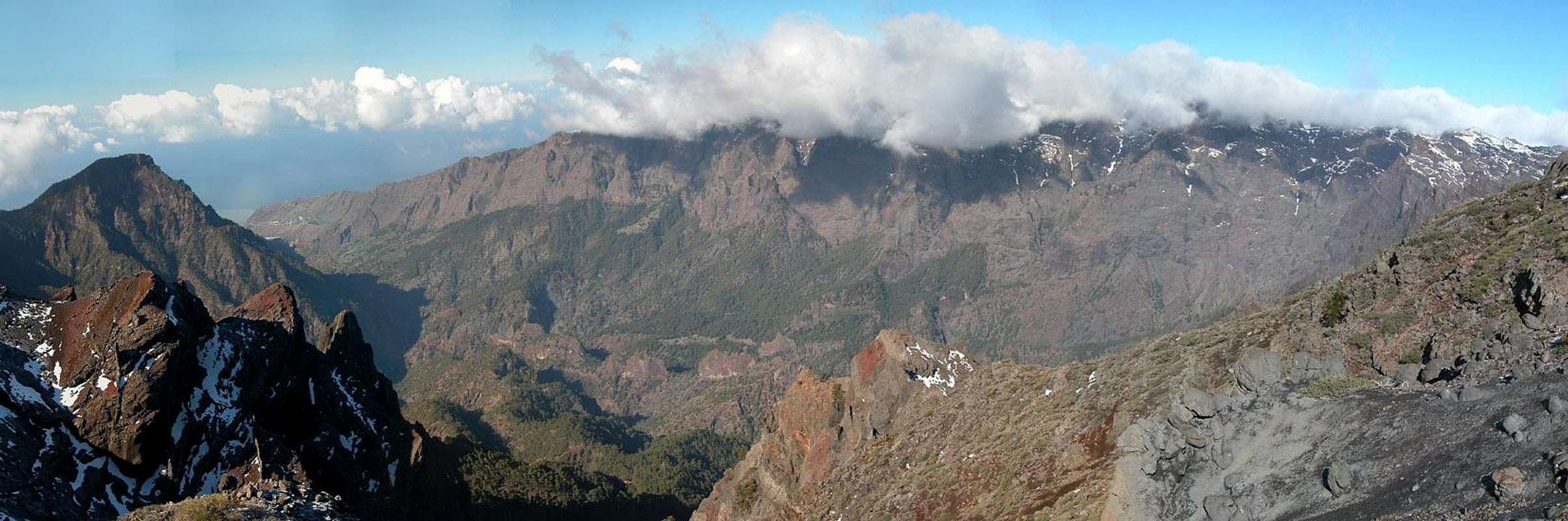
1 – La Isla Bonita
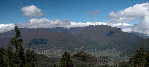 Caldera de Taburiente seen across Aridane Valley |
La Palma is an island of many attributes: Isla Bonita, Isla Corazon, Isla Verde. It is arguably the most beautiful of the Canarian Islands but definitely the best hiking ground of all. Like the other six islands La Palma is of volcanic origin and here you can actually see and sometimes smell the volcanic activity. With approximately 2 million years of age the island is among the youngest of the Canarias, compared to Fuerteventura or Lanzarote which are about 25 million years old. Consequently La Palma is among the most active islands and in fact the last eruption to take place in the Canarias occured here in 1971, an eruption, which created Volcán Teneguía.
Similar to neighbouring Tenerife, La Palma is an island of superlatives. On the island you will find the largest erosion crater on earth, the Caldera de Taburiente, almost 2500m high, with a diameter of 9km. Though La Palma is one of the smallest islands of the Canaries – only El Hierro is smaller – it contains a two more mountain ranges, Cumbre Nueva and Cumbre Vieja. The latter almost reaches 2000m and consists of a huge underlying volcano with about 120 craters breaking the surface. Thus, La Palma can be called the most mountainous island on earth, with a mass-to-surface ratio surpassed by no other island on the planet.
Due to its young age there are only few spots on the island in which you can climb. The underlying rock is far too brittle. There are some basalt walls on the west coast where one can climb but nothing of bigger proportions. Instead, there is absolutely perfect hiking to be found on the island. There are numerous hiking trails, all of them marked perfectly, Canarian style. Multiday trekking trails are marked red, regional trails are marked yellow and local trails are marked in green. Often the trails follow old caminos, mule trails which for centuries have connected the villages on the island. In many cases these trails are paved with cobblestones, which become slippery in wet conditions.
  |
There are two trekking trails, both taking about two days to complete, mainly because of the big elevation differences they scale. In the south of the island, at its very tip near Faro de Fuencaliente, the Ruta de Los Volcanes starts. It follows the ridge of the Cumbre Vieja Range, touching all of the major summits and climbing to the main summit of Volcan de la Deseada at 1945m. It ends at Rifugio el Pilar, where Cumbre Vieja and Cumbre Nueva connect with each other. In the north-west of the island at el Time the second trekking trail starts, The Ruta de la Cresteria around the Caldera de Taburiente. This trail likewise touches all summits on the crest, among them the highpoint of the island, Roque de los Muchachos (2232m). It ends at Reventon Pass on Cumbre Nueva, the saddle through which in former times the main trade route led from the east of La Palma to its west. Both trekking trails can be connected and together they take three to four days to complete.
Weather always is an issue on La Palma, especially when hiking in the high mountain ranges. Often you have to fight against fierce winds and the summits are covered in trade wind clouds. Also, weather changes can occur in minutes, most likely due to the north-south orientation of the island. A change in wind direction may result in clouds suddenly piling up on one side of the island while the other enjoys sunshine. Orientation on Cumbre Vieja can become hazardous in these conditions.
Last - but not least - La Palma has been in the headlines after the disastrous Christmas Tsunami of 2004. A theoretical scientific paper by Ward and Day claims that part of the island will collapse, creating a killer tsunami of unheard-of proportions. The theory is heavily contested and I thought I should dedicate a chapter (#3) to discuss the pros and cons.
2 – A Short Geological Summary
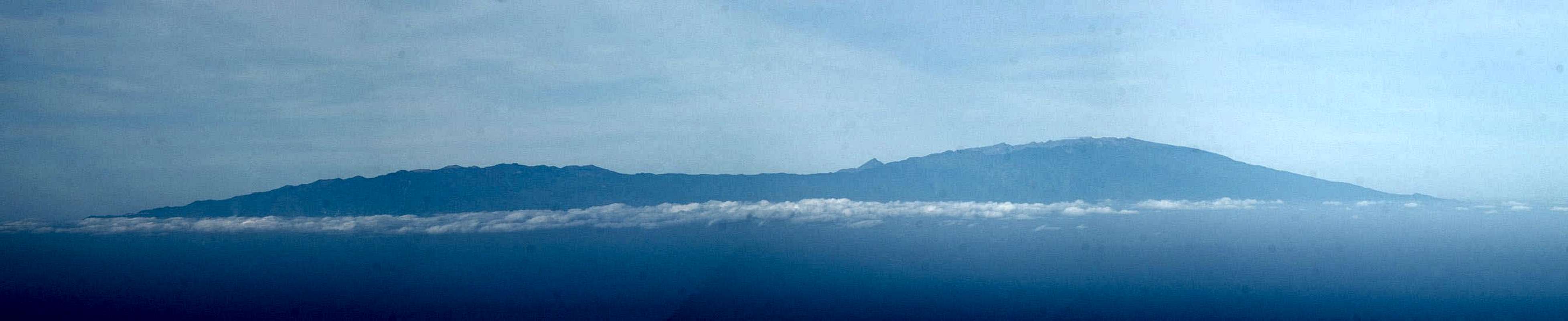
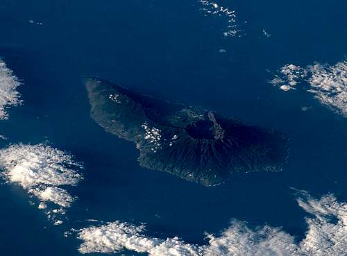 La Palma as seen from the ISS. Cumbre Viejato the left, Cumbre Nueva in the centreand Caldera de Taburiente to the right
La Palma, though one of the youngest Canarian islands, has one of the most interesting geological histories of them all. It is a history of volcanism and erosion, the volcanism being very explosive, the erosion culminating in multiple giant landslides. Each of the subsequent geological periods was ended by one of these landslides.
The first phase started some 2 million years ago, when a giant shield volcano started building up underneath the surface of the Atlantic Ocean. Between 1.8 and 1.2 million years ago the volcano – called the Garafia Volcano - broke the surface and quickly rose to elevations between 2500m and 3000m. The steeply sloping flanks became unstable so that 1.2 million years ago a huge landslide broke away the southern flank of the volcano.
After the collapse several vents were released and within the collapse zone and another volcano quickly built up – the Taburiente Volcano, the remnants of which form the northern and eastern parts of the Caldera de Taburiente and thus the highest parts of the island. The Taburiente Volcano also was a shield volcano with its centre almost exactly where you find the centre of the caldera today. Several rifts formed, the largest one to the south: the long stretched curved ridge of the Cumbre Nueva. This rift volcano - like the Garafia Volcano before it - grew too quickly, resulting in an instability which led to another landslide 560 000 years ago. The western part of the Cumbre Nueva rushed to the sea, taking with it large parts of the Taburiente Volcano. 180 000 – 200 000 cubic metres of material crashed down into the sea forming the Aridane Valley in the centre of the island and the erosion crater of the Caldera de Taburiente.
From that time onwards volcanism on La Palma started moving southwards. The Cumbre Nueva is the first indication of that southward drift, which has not stopped until today. After the collapse of the western part of the Cumbre Nueva and the southern part of the Taburiente Volcano, two things happened quasi simultaneously: in the centre of the collapse zone again a volcano formed – the Bejenado Volcano, the remnants of which are Pico Bejenado today. This volcano completed the formation of the Caldera de Taburiente by closing it towards the south and only leaving the south-western mouth open through which Rio Taburiente started washing away the erosion materiel from the inside of the quickly forming cratter. At the same time, on the western slopes of the broken down Cumbre Nueva, however further towards the south, the Cumbre Vieja started piling up along a long rift running north to south. The oldest lavas of the Cumbre Vieja have been dated to 125 000 years of age, mainly occurring in the north of the range. At the same time volcanism moved further southwards moving the boundaries (coasts) of the island in that direction. The last eruption, that of Volcan Teneguia, is an indication for this southward drift. During the outbreak again new land was gained at the southern tip of the island. Also, underwater eruptions to the south of La Palma are rather common.
3 – The Tsunami Hazard – Or Not
After the Christmas Tsunami of 2004, when large stretches of the Indian Ocean were devastated killing thousands of people and leaving hundreds of thousands homeless, La Palma made it to the headlines as the possible cause of a unheard-of Mega Tsunami. In 2001 Steven Ward and Simon Day had published a scientific paper in which they simulated a collapse of the central part of the Cumbre Vieja on the island. In the worst case scenario a giant Tsunami would be created, devastating the whole Atlantic seaboard with huge waves of up to 25m flooding North Africa and sweeping across Florida and the islands of the Caribbean Sea. The paper, as well as its dire consequences, has been heavily contested, especially by locals. But with the advent of the 2004 Tsunami La Palma gained notoriety nonetheless.
As explained in the brief geological abstract of the last section, massive – even giant – landslides are not uncommon on La Palma or any of the other Canarian islands with the exception of La Gomera. The picture above shows the ocean floor analysis around the western Canarian islands, where large deposits of landslide debris can be found. On Tenerife the giant crater of the Cañadas del Teide was washed down to the north coast of the island through the Orotava Valley. Less known, but of similar dimensions, part of the Cumbre Dorsal slid down the Guimar Valley to the south of the island. Triangularly shaped El Hierro – similar in age to neighbouring La Palma – witnessed three such landslides. La Palma itself also saw multiple avalanches as has been described in the last chapter.
Historical evidence thus confirms any hypothesis that landslides can occur on the Canaries, but what makes La Palma special? Well, La Palma can be called the most mountainous island on this planet. While it is very small – 730 square kilometres – it also is very high. The Caldera de Taburiente with its highpoint, Roque de los Muchachos, reaches 2426m while the Cumbre Vieja reaches almost 2000m. The volcanic material, which makes up the mountains, is very young by geological terms and hasn’t yet settled into solid rock. Everywhere on the island you find lava and cinder but almost nowhere there is anything like basalt or granite.
In 1949, three of the volcanoes of the Cumbre Vieja - San Juan, Montaña del Fraile and Pico Nambroque – erupted simultaneously. Large lava flows covered the western parts of the island and there were a lot of heavy earthquakes. During the eruption a large fault of 3km length developed near the top of the range and here the western part of the Cumbre Vieja slipped by up to 4m (12ft). Since deep chimneys have been found in the higher regions of the range, which consists of porous, water-filled rocks, it is expected that the next eruption in this central region of the Cumbre Vieja will be very explosive. This might lead to the fault line widening and eventually a large part of the range rushing down to the sea. With huge amounts of material (500 billion tons) huge waves would be created, which finally would hit the US and the Gulf of Mexico with devastating effects, leaving flooded Canarian islands in their wake.
Now this is the doomsday scenario – the worst case which might happen – but reality will most likely be very different. For starters, the ‘49 fault line is often interpreted quite differently. Some scientists explain that after the eruptions and quakes of ’49 the Cumbre Vieja simply settled into a more stable configuration by filling gaps, left from the Cumbre Nueva landslide 560 000 years ago. Even if the western part of the Cumbre Vieja will slide down to the sea – which eventually it certainly will – consequences might turn out to be far less alarming than the doomsday scenario predicts. The amount of material and the speed with which it goes down to the sea has large consequences on the size and speed of the possible tsunami waves. And last of all – who can tell when this event will happen and whether it will be anytime soon.
4 – La Palma on SP
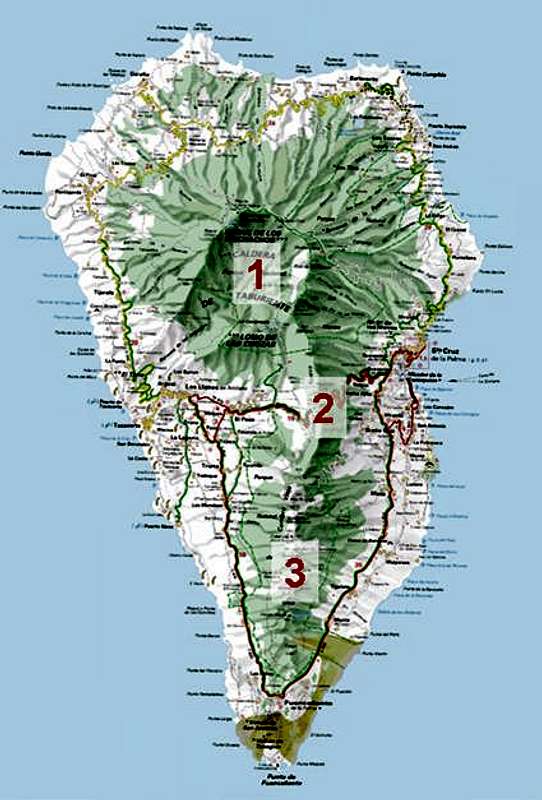 |
There are about a dozen mountain pages for La Palma on SP, most of them for mountains of the Cumbre Vieja Range. Caldera de Taburiente has its own page and five summits of its crest have also been added. Currently there are no mountains of the Cumbre Nueva Range on SP, mainly because the range can be traversed by a dirt road by car. Some of the summits are off limits due to radio and tv installations on their tops.
- Caldera de Taburiente overview (this page
- Caldera de Taburiente (separate page)
- Cumbre Nueva
- Cumbre Vieja
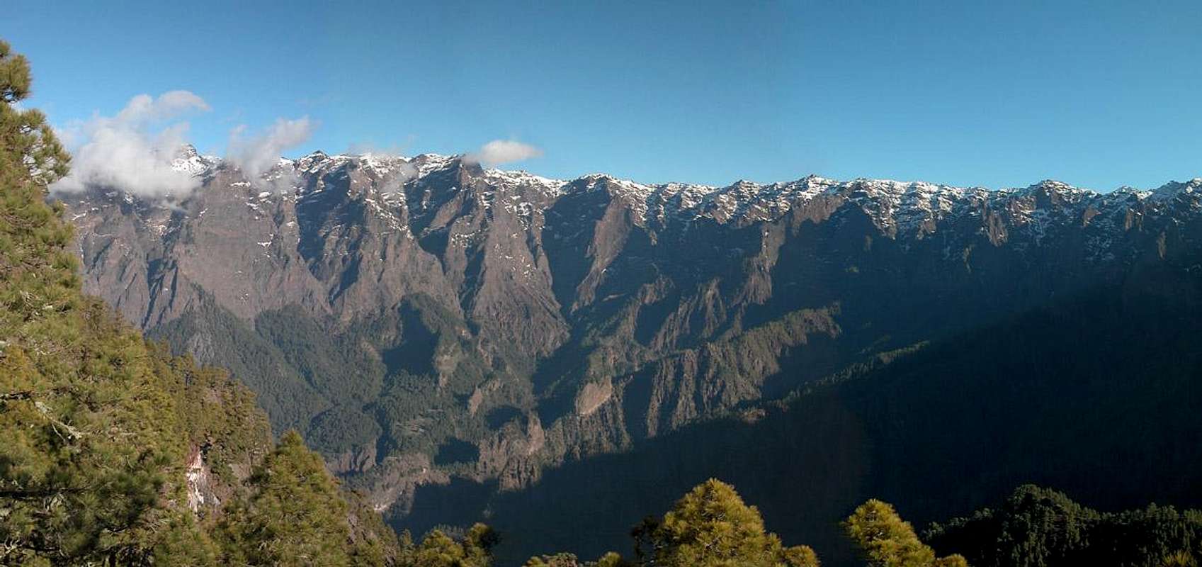
5 – Caldera de Taburiente
 |
Caldera de Taburiente with its external slopes takes up the complete northern half of the island of La Palma (Islas Canarias). It is, simply said, the largest erosion crater on this planet. Just figure the following statistics:
- Circumference: 29km (14miles)
- Diameter: 9km (5miles)
- Average height of the caldera wall: 2000m (6000ft)
- Highest summit: Roque de los Muchachos: 2426m (7959ft)
- Outside elevation: 0m (0ft)
- Inside elevation: 700m (2100ft)
All this results in one of the truly most impressive mountain ranges you can find. All the highest mountains of La Palma are located on the crest of the crater, easy to access from the outside but impossible to get at from inside the caldera. Here you can find vertical walls of up to 1500m height, notably the ones to the north-east of the crater. The Caldera is open on its southwestern side, where Rio de Taburiente, the only river on the Canarias, has carved out a deep gorge (Barranco de las Angustias) towards the sea. This gorge in itself is worth seeing since even here you can find those 1000m walls.
 |
There is a two to three day trekking trail along the northern and eastern part of the Caldera Crest, Ruta de la Cresteria, which starts at Puerto Tazarcorte in the west of the island and ends at Reventon Pass on Cumbre Nueva.
For more information see the Caldera de Taburiente Page.
6 – Cumbre Nueva
 Cumbre Nueva as seen from Pico Birigoyo
Not much can be said about the Cumbre Nueva. It is a ridge, which connects the two taller ranges of La Palma, Caldera de Taburiente with Cumbre Vieja. Running north to south in a large curvature Cumbre Nueva separates the east of te island from its west. Its summits reach about 1450m between Rifugio el Pilar and Reventon pass. Here a mountain road follows the ridge winding between the few summits. From the pass the ridge rises constantly to Pico Ovejas (1854), its highest point.
The range received its name not from its age, neighbouring Cumbre Vieja is much younger than Cumbre Nueva. Instead it was named for the caminos which cross across its passes. The original (old) camino connected the east of the island with the west across the pass near Refugio el Pilar. Only later a new camino, Camino Real, was built across Reventon Pass in the middle of Cumbre Nueva. Today the Camino is one of the steepest hiking trails you can find anywhere on earth. After the Tunel de la Cumbre was built, the two caminos returned to their original destination, serving as hiking trails for the many visitors of the island.
7 – Cumbre Vieja
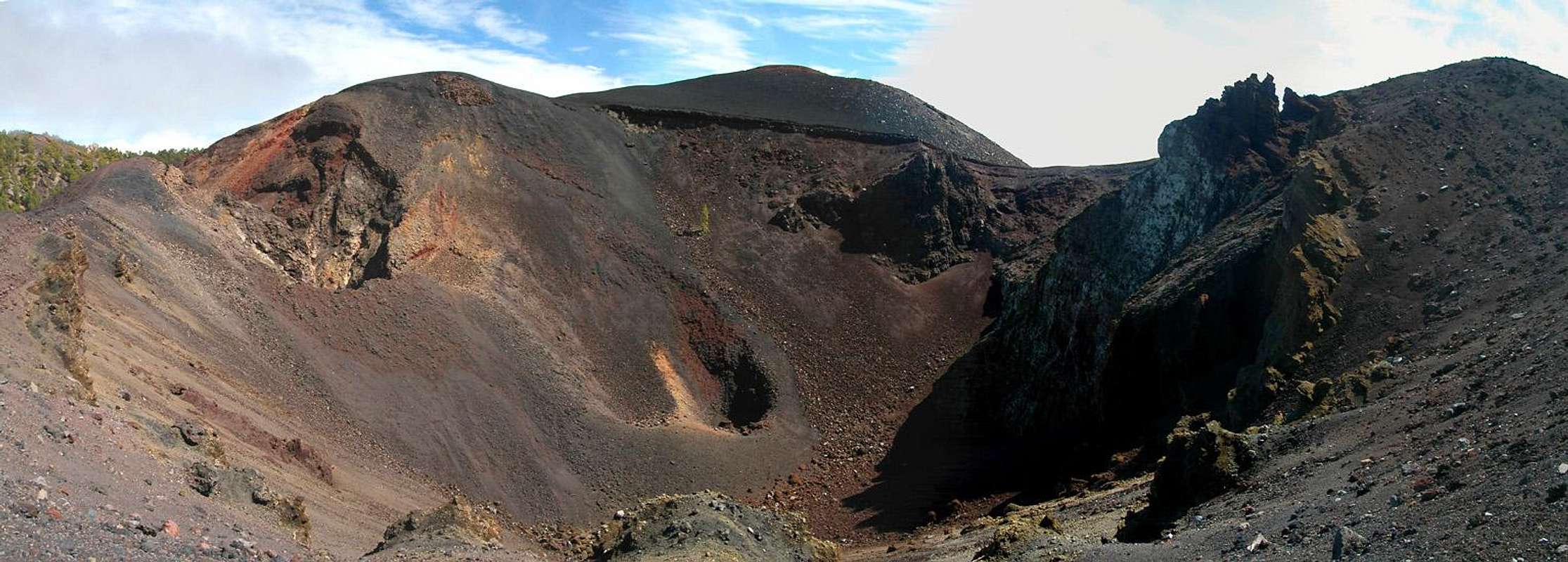 |
The Cumbre Vieja – though its name indicates otherwise – is the youngest part of the island. It started piling up on the remnants of the Cumbre Nueva landslide some 125 000 years ago. Today it is a range consisting of 120 volcanic craters, reaching almost 2000m in height. Its tallest volcano is Volcan de la Deseada, a twin-peaked cinder cone right at the centre of the range. Cumbre Vieja reaches across the southern part of the island from the eastern coast to the western one and has its last summit at the southern tip of the island. Volcan Teneguia is the youngest mountain of La Palma, having been created during its eruption in 1971.
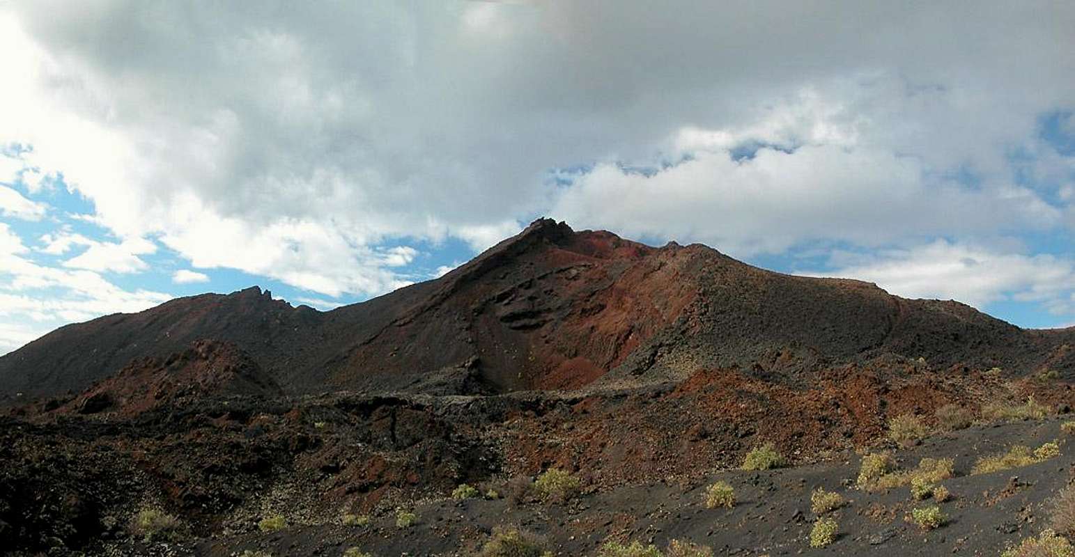 |
You find habitation only up to roughly 700m on all sides of the Cumbre Vieja. Above this a beautiful forest of Canarian Pines rises to roughly 1200m, leaving the remaining 800m a veritable volcanic desert with scree and cinder. The range is often swept by fierce winds and quite often heavy trade wind clouds develop around its peaks. A two day trekking trail, Ruta de los Volcanes, crosses the range starting at Rifugio el Pilar in the north and ending at Faro de Taburiente at the southernmost tip of the island.
8 – Traffic and Accommodation
 |
Camping is a bit of a problem on La Palma. There are some official campgrounds in the north but the one near Los Canarios is still a project. There are, however, a couple of "Zonas Recreativas" where sometimes you are allowed to pitch a tent. For Caldera de Taburiente this would be at Playa de Taburiente (right in the centre) for which you have to obtain a one day permit beforehand. It can be obtained at the visitor's center at the intersection of LP-2 and LP-202. For Cumbre Vieja there are two camping zones near rifugio del Pilar and near Montaña de la Venta. For reservations ask at the Rifugio.
Other accommodations are no problem. Every European travel office will be able to book hotels, rooms and apartments for you. I won't include any links here because all of them definitely are commercial. Another option is to rent a finca (rural house) from the owners directly. You'll have to google for these but sometimes prices are low enough for the scheme to be worthwhile. Howevver, take into account that flights to the Canaries are often fully booked in advance, especially during the Christmas or Easter holidays.
9 – Red Tape
There are two large National / Natural Parks on the island in which the usual restrictions apply: Parque Nacional de la Caldera de Taburiente and Parque Natural de Cumbre Vieja. Staying overnight in one of the parks is only allowed in the designated camping areas and huts and you have to apply for permits at the Centro de Visitantes de Parque Nacional de la Caldera de Taburiente east of El Paso.
The Cumbre Vieja is an active volcanic range and might be closed due to activity. However, La Palma’s volcanic activity cannot be compared to the eruptions of e.g. Monte Etna on Sicily. Here eruptions only take place every 30 or 40 years.
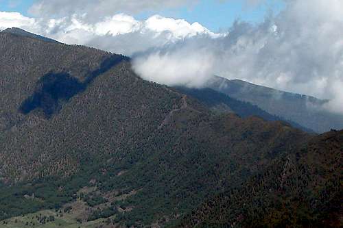
10 – Weather Conditions
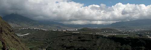 Heavy weather above the Aridane Valley
Like all other Canarian islands, La Palma is located in the trade wind zone. Humid north-easterly winds sweep over the island and being forced to higher altitude by the high mountain ranges the humidity condenses in heavy clouds between 1500 and 2000m. Therefore the northern regions of the island are humid with lots of vegetation while on the southern sides you find desert-like conditions. On the other hand, there are no reliable weather forecasts for the mountain regions of La Palma. Often a cloudless day turns into a foggy one within half an hour. Especially the Cumbre Vieja Range is prone to these fogs and here orientation among the lava and scree fields gets very difficult.
The inner crater of the Caldera de Taburiente is prone to landslides after heavy rainfalls. The hiking trail from La Cumbrecita into the inside of the crater is often affected. If you plan to hike this path better inform yourself at the Centro de Visitantes near El Paso.
Forecasts for the coastal regions, however are available. You have to subtract 1°C for every 100m of altitude so that Roque de los Muchachos will still be near freezing when the coasts have already fine and sunny beach weather. The following table gives a little overview about the average weather data of the capital of Santa Cruz:
| Month | Jan | Feb | Mar | Apr | May | Jun | Jul | Aug | Sep | Oct | Nov | Dec |
| Avg. day temp.[°C / °F] | 21 / 70 | 21 / 70 | 22 / 72 | 22 / 72 | 22 / 72 | 24 / 75 | 25 / 77 | 26 / 79 | 26 / 79 | 26 / 79 | 24 / 75 | 22 / 72 |
| Avg. night temp.[°C / °F] | 15 / 59 | 14 / 57 | 15 / 59 | 16 / 61 | 17 / 63 | 18 / 64 | 19 / 66 | 21 / 70 | 21 / 70 | 19 / 66 | 18 / 64 | 16 / 61 |
| Water temp.[°C / °F] | 19 / 66 | 18 / 64 | 19 / 66 | 19 / 66 | 19 / 66 | 20 / 68 | 22 / 72 | 23 / 73 | 22 / 72 | 22 / 72 | 21 / 70 | 20 / 68 |
| Sunny Hours / Day | 5 | 6 | 6 | 7 | 8 | 9 | 10 | 9 | 8 | 6 | 5 | 5 |
11 – Maps & Books
11.1 – Maps
Generally, it is very difficult to obtain good hiking maps for the Islas Canarias. La Palma is an exception, as there is an excellent Map by Freytag & Berndt, which includes all hiking trails with the correct names (which have been changed in the early 2000s).
- La Palma
1:30000
Edition Freytag & Berndt
ISBN: 3-7079-0346-X
11.2 – Digital Maps
Kompass is the only company known to me which offers GPS digital Maps. In addition for those of you with Garmin GPS receivers there is a map source map set of all Canarian islands out there with the exception of Lanzarote. Currently you can download it for free.
- La Palma
Kompass GPS4232
Kompass Verlag
ISBN: 3-85491-217-X - Islas Canarias
Map Source custom map
By Manfred Pepper
downloadable zip-file
11.3 – Books
An excellent hiking guide available in both German and English is:
- La Palma
Klaus Wolfsperger / Annette Miehle-Wolfsperger
Rother Verlag
ISBN: 3-7633-4246-X (German)
ISBN: 3-7633-4808-5 (English)
12 - External Links
- Simon and Ward Tsunammi Paper
- Tsunami Theory in Detail
- Crusade against the Tsunami Theory
- Geology and Volcanology of La Palma and El Hierro
rgg - Nov 25, 2010 7:21 pm - Voted 10/10
External LinksI found this one to give very accurate info about the trails: Hiking trails on La Palma
Gangolf Haub - Nov 26, 2010 7:11 pm - Hasn't voted
Re: External Linksgracias for the links. I'll have too check them and add them to the pages.