
-
 39654 Hits
-
 96.38% Score
-
 59 Votes
|
|
Area/Range |
|---|---|
|
|
28.27233°N / 16.63811°W |
|
|
Hiking, Mountaineering, Sport Climbing, Scrambling, Canyoneering |
|
|
Spring, Summer, Fall, Winter |
|
|
12198 ft / 3718 m |
|
|
1 - An Island of Superlatives
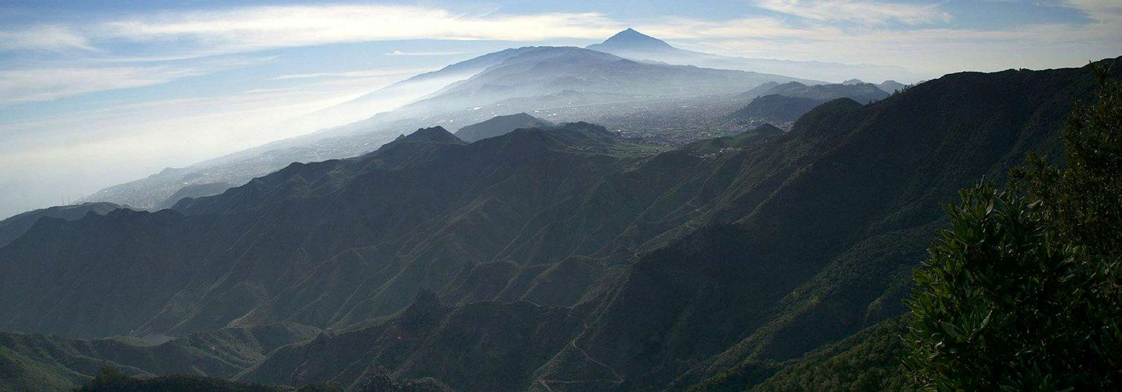
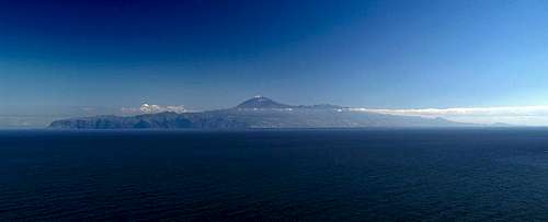 Tenerife as seen from Agulo on La Gomera Tenerife as seen from Agulo on La Gomera |
Among the seven islands of the Islas Canarias Tenerife stands out in numerous ways. It is the largest of the islands with an overall area of 2050 square kilometres. It also is the highest one, with Pico del Teide, the tallest mountain of Spain. It is home of the largest volcanic crater on earth, the giant Cañadas del Teide, a crater which reaches about 50km in circumference. !0 million tourists visit the Cañadas each year and they are only a fraction of the overall tourist traffic.
Though Tenerife is home to mighty Teide it is not the most mountainous island of the archipelago. That honour goes to the mach smaller island of La Palma which basically consists of three high mountain ranges and nothing more. Tenerife is much more complex. There are five mountain ranges on the island and large parts, especially in the south, could be called flat. Of the mountain ranges only the Cañadas and the Cumbre Dorsal Range are taller than 2000m while the other three ranges reach between 1000m and 1500m.
These lower ranges, the Anaga, Teno and Adeje Regions – which are the oldest ones of the island – make up for their lack in height by their wildness. Especially the Anaga peninsula in the far north-west of Tenerife can compete with any other wild mountain region on this planet. Profound canyon-like barrancos alternate with knife edge ridges and there are basalt towers anywhere. Teno also has its wild aspects. Its highest part is a plateau which also divides into canyons and knive-edge ridges as you get close to the sea. Moost of the Adeje region already has eroded away, leaving the massive bulk of Roque del Conde as the landmark of southern Tenerife.
The Cumbre Dorsal, which connects Anaga with the Cañadas, is a long stretched back which drops steeply to the sea on both of its sides. Home to some of the latest eruptions of Tenerife it is a colourful reminder of the volcanic history of the island. But none of the ranges can compete with the Cañadas del Teide, a giant crater at the centre of the island, located at roughly 2000m of elevation. Out of it rises the giant cone of the stratovolcano of Teide with its lateral crater Pico Viejo. The whole area is a desert-like moonscape which shines in all shades of yellow and red. It is home to the Caldera rim mountains like Guajara or El Sombrero and of the Roques de Garcia, a long line of lava towers right in the centre of the giant crater plain.
There’s something for everyone to be found on Tenerife. There’s volcano mountaineering on Teide, Guajara and the rim mountains, there’s rock climbing near Guimar and Puerto de la Cruz as well as on the Roques de Garcia and Pietras Amandillas in the Cañadas. There are numerous hiking possibilities with a large network of well marked trails all over the island. Last, but not least, you might even think of going to the beaches, which are wide and sandy in the south, small and rocky in the north.
2 – A Short Geological Summary
  |
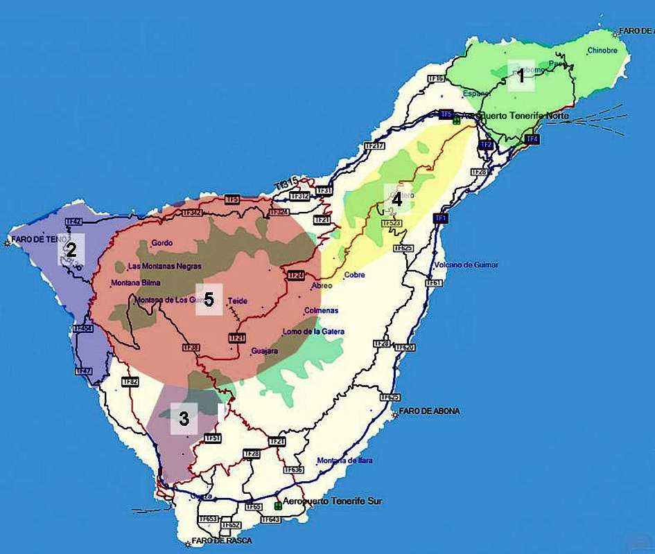
Tenerife, like we know it today, is the result of two mighty competing forces which sculpted the island over the last 7 million years: volcanism and erosion. The oldest rocks on the island are 7 million years old and can be found in the Anaga, Teno and Adeje regions (marked 1, 2, 3 on the map in the following section). When the undersea volcanoes reached the surface of the Atlantic, their eruptions took place along long fissures which emitted lava to both of their sides quickly piling up the high backbones of sharp ridges. It is not evident today whether the three regions formed a small archipelago of three islands or if they were connected at the centre but at estimated heights of about 2000m each the latter is more probable. Quite naturally erosion of sea and rain immediately set in, washing the gravel-like lava to the sea, while leaving the basalt structures (magma which cooled of within the fissures) standing amidst the debris. Thus the profound barrancos and knife-edge ridges of Anaga and Teno were born. The latter and also part of the Adeje region later were covered with lava by new eruption forming the Teno high plateau in the north-west of the island.
About 5 million years ago volcanic activity shifted to the centre, now definitely forming a single island out of the three old regions. Still eruptions took place along fissures, thus creating the huge backbone of the Cumbre Dorsal (4 on the map). Part of the Cumbre (the south-western part in fact) later was buried by further eruptions and the Cumbre itself remained pretty active until today. It certainly gives an indication of that Anaga, Teno and Adeje might have looked like at the birth period of the island. Volcanic Activity subsided during this era, which lasted more than 4 million years, but which regained momentum in the next phase.
Half a million years ago the type of volcanism changed. The fissures had subsided and now a huge stratovolcano was born. In the centre of the island (3 on the map), in the Teno, Adeje, Cumbre Dorsal triangle a lot of activity formed a precursor of Teide, a broad, shielded volcano covering the whole area. What happened next is still not finally agreed upon by geologists. According to an older theory this volcano collapsed in its centre to form the Cañadas del Teide. A newer theory, based on the fact that you can find a huge shelf beneath the surface of the Atlantic ocean to the north of Tenerife, claims that the northern slope of the volcano became unstable and a giant landslide carried much of it to the sea, leaving the Cañadas del Teide and the broad Orotava Valley in its wake. Since landslides of enormous proportions are not unheard of on the Islas Canarias this theory bears more likeliness than the older one.
However it was formed, to the north of the Cañadas, right on the rim of the crater, soon another stratovolcano piled itself up forming the cone of what is now known as Pico Viejo and later moving the centre of activity eastwards to pile up Teide. The slopes of the Teide / Pico Viejo cone bear witness of the more recent eruptions, where lava flowed down in huge streams to the plain underneath. The latest volcanic activity has taken place in the Cañadas (Narices del Teide on Pico Viejo) and north of the Cumbre Dorsal (Montaña Siete Fuentes, Montaña Fasnia and Montaña de las Arenas). The current rate of eruptions is one in about 200 years.
3 - Tenerife on SP
|
Tenerife has been covered already pretty extensively on SummitPost. The five mountain ranges are listed according to their age. Currently each of the ranges has at least one mountain page on SP and the following listing is supposed to give an overview.
4 – The Anaga Range
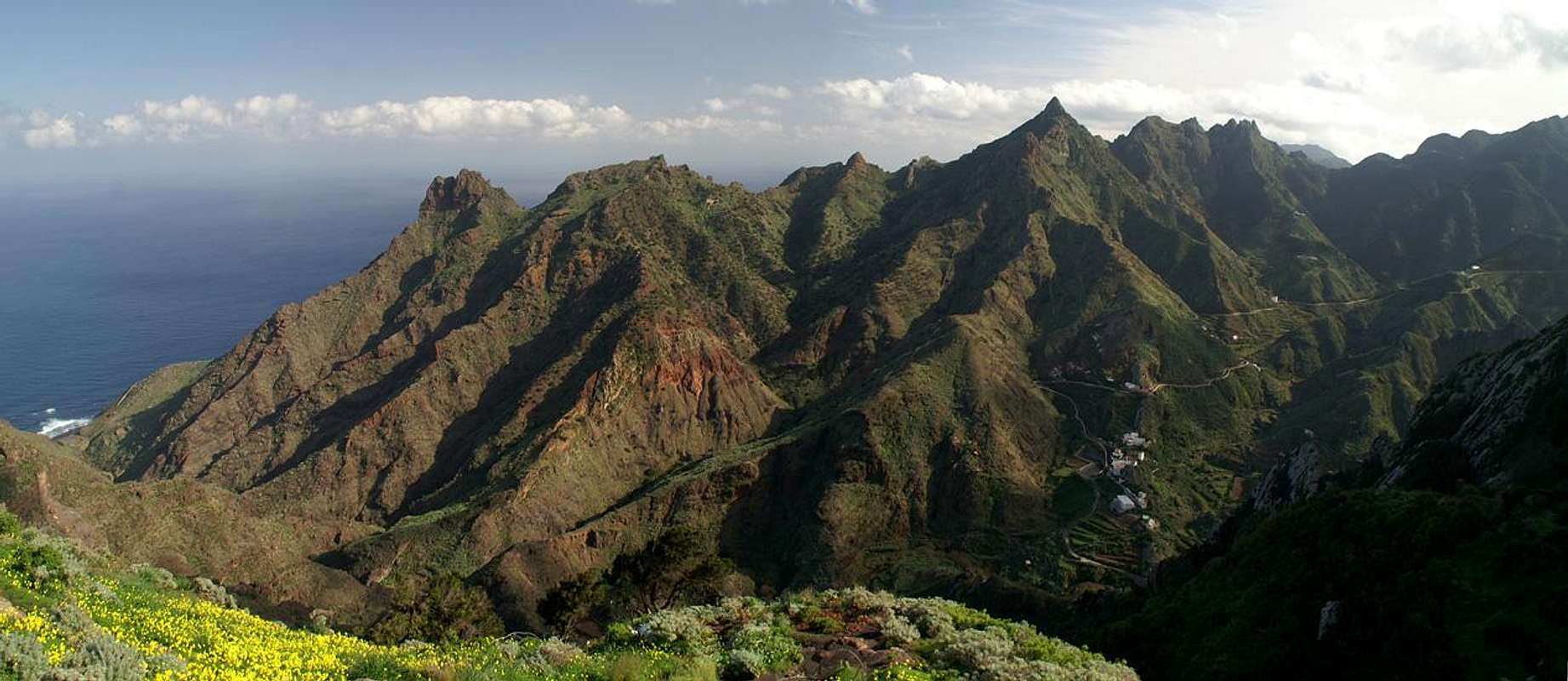 |
Anaga is the name of the peninsula, which lies in the north-east of Tenerife, east of the line from Santa Cruz de Tenerife, to San Cristobal de La Laguna. It is the oldest part of the island and consists of a long chain of mountains, which stretches from Chimorga in the east to Tejina in the west. From this chain, which reaches elevations between 800m and 1000m multiple side ridges stretch out to the north and south. The southern ones are longer and less wild than the northern ones, which clearly display their origin – volcanic fissures with a funnel here and there left standing as a basaltic rock tower.
The Anaga crest is covered in a dense cover of Laurisilva, the Canarian cloud forest, made up from laurel, tree heather and birches. It is very dense and dark so that only few of the mountains on the crest offer decent views. The Anaga Highway, a narrow and winding road, which connects the far-off villages with the rest of the island winds its way along the crest, offering easy access to the few lookout peaks. The Laurisilva, which grows between 700m and 1500m is fed by trade wind clouds, which constantly push across the crest. Fog is rather common, but it is the wet kind which leaves you drenched in a few minutes.
Characteristic for the Anaga range are the knife-edge ridges of the north, which often end in impressive towers and spires. Roque de Taborno is the best known one among these but certainly not the most impressive one. Climbing is almost impossible on the Anaga peninsula since the rock quality is very poor. Roque de Taborno can be climbed and while the normal route is not difficult it is very dangerous because of brittle stands and ledges which might break off at any time. On the other hand, there are a lot of excellent hiking trails in the north of the peninsula. Old caminos, which connect the hamlets and villages of the range with each other and irrigation channels are the most common types of paths. Here and there you will a path high above the coast or one following one of the profound barrancos. In the south of the crest there are only few possibilities, however.
5 – The Teno Range
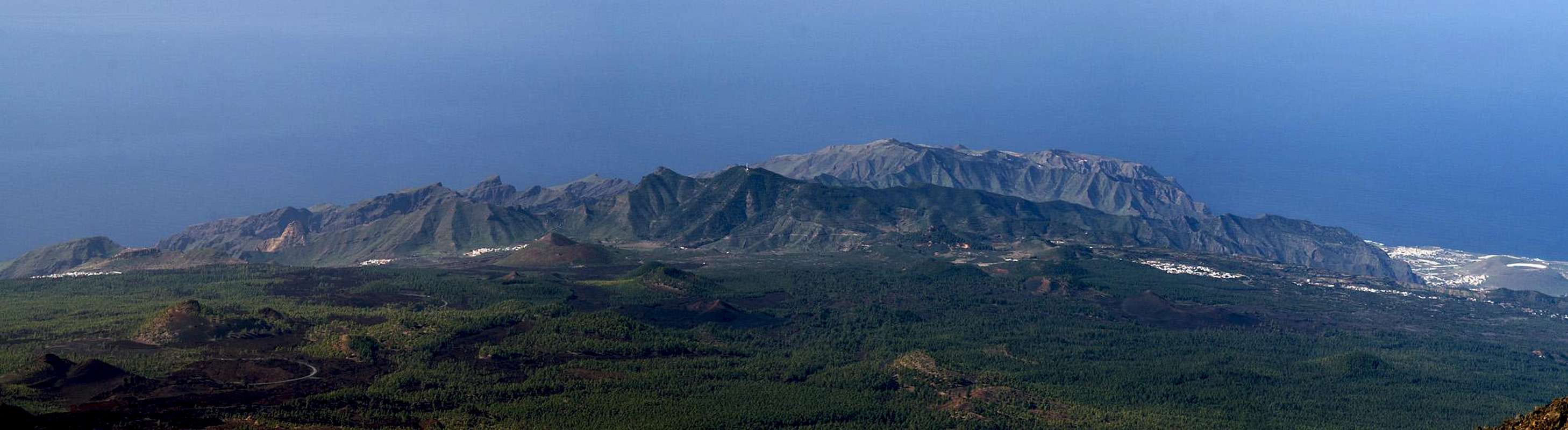 |
Named after the little hamlet of Teno Alto (maybe also the other way around) in its centre, the north-western part of the island is almost as old as the Anaga peninsula in the north-east. Herer also you can find a long ridge starting at Roque de Chinaco in the north-west and ending in the Teno Range’s highest summit Cruz de Gala. However, the eastern part of the range has been buried by the eruptions of Pico Viejo and its satellites so that a large part of the range is a high plateau today.
Along the northern and western coasts, however, the Teno Range is very wild. The mountains tower directly 500m to 700m above the sea and long knife-edge ridges connect them with the high plateau in the east. These cliffs, Los Gigantes, are among the best known features of the Teno Range. In between the cliffs you find long and profound canyons, the wildest one of which is Barranco de Masca, 5km long winding gorge from which you barely see the light of day. The hamlet Masca is visited by hordes of tourists each day but only a fraction of them ventures into the barranco. Though a path has been marked through the canyon it still is pretty difficult to scramble though.
The Teno plateau, like the crest of the Anaga peninsula, is often swept by trade wind clouds. Consequently there is a large patch of laurisilva (east of Teno Alto) in which orientation can be very difficult, especially in foggy conditions. On fine days, however, you can see the islands of La Gomera and La Palma from the Teno summits, views for which the range is famous.
6 – The Adeje Region
 Los Riscos, Roque de los Brezos, Roque Imoque
The south-west of Tenerife is known for its beaches rather than for its mountain. Still, there is one of the oldest ranges on the island, born together with Anaga and Teno, to the east of the town of Adeje. Today only a few summits remain from that era, all slightly taller than 1000m. Roque del Conde is the best known among them, if only for its sheer size. It is the first mountain you see as you close in on the harbour of Los Christianos, towering with its broad south face above the south of the island. Still, Roque del Conde is not the highest of the Adeje summits; that honour goes to Roque Immoque to its north.
Erosion has done away with most of this range and only a few mountains are left standing. Also, there is a famous canyon, Barranco del Infierno, leading from Adeje eastwards towards the mountain. It’s a popular hike and ends at a high waterfall, which might even carry water if you are lucky. The Adeje region is very dry giving the mountains a desert-like appearance.
7 – Cumbre Dorsal
 |
The Cumbre Dorsal is the long stretched volcanic chain which stretches from El Portillo, the portal to the Cañadas to San Christobal de La Laguna. It was created 5 million years ago, when a giant cleft opened and emitted all sorts of lava, quickly piling up to a great height. Today, the highest mountains can be found near the crater of the Cañadas del Teide. They reach aabout 2400 – 2500m.
After the cleft volcanism subsided, new, smaller volcanoes appeared all over the range, displaying the characteristic cones of stratovolcanoes. The Cumbre still is an active zone. The last eruptions occurred 300 years ago on its south side, when three volcanoes erupted simultaneously: Montaña Siete Fuentes near Arico in the south, Montaña Fasnia near the likewise called village and Montaña de las Arenas high above the town of Arafo in the narrow canyon of Barranco de las Gambuesas.
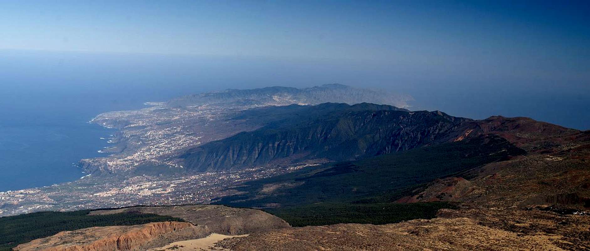
A second characteristic of the Cumbre are the two large valleys which cut into it. To the north it is the giant cauldron of the Orotava Valley, which touches the Cumbre on its westernmost point while in the south the similar Guimar Valley heads up further to the east. Both valleys combine in Degollada de la Crucita, a saddle across which for ages the traffic from north to south has run. Countless feet have treaded deep ruts into the trail, the pilgrimage trail Cmino de la Candelaria, which runs from La Orotava to the hermitage of La Candelaria on the south-eastern coast.
8 – Las Cañadas del Teide
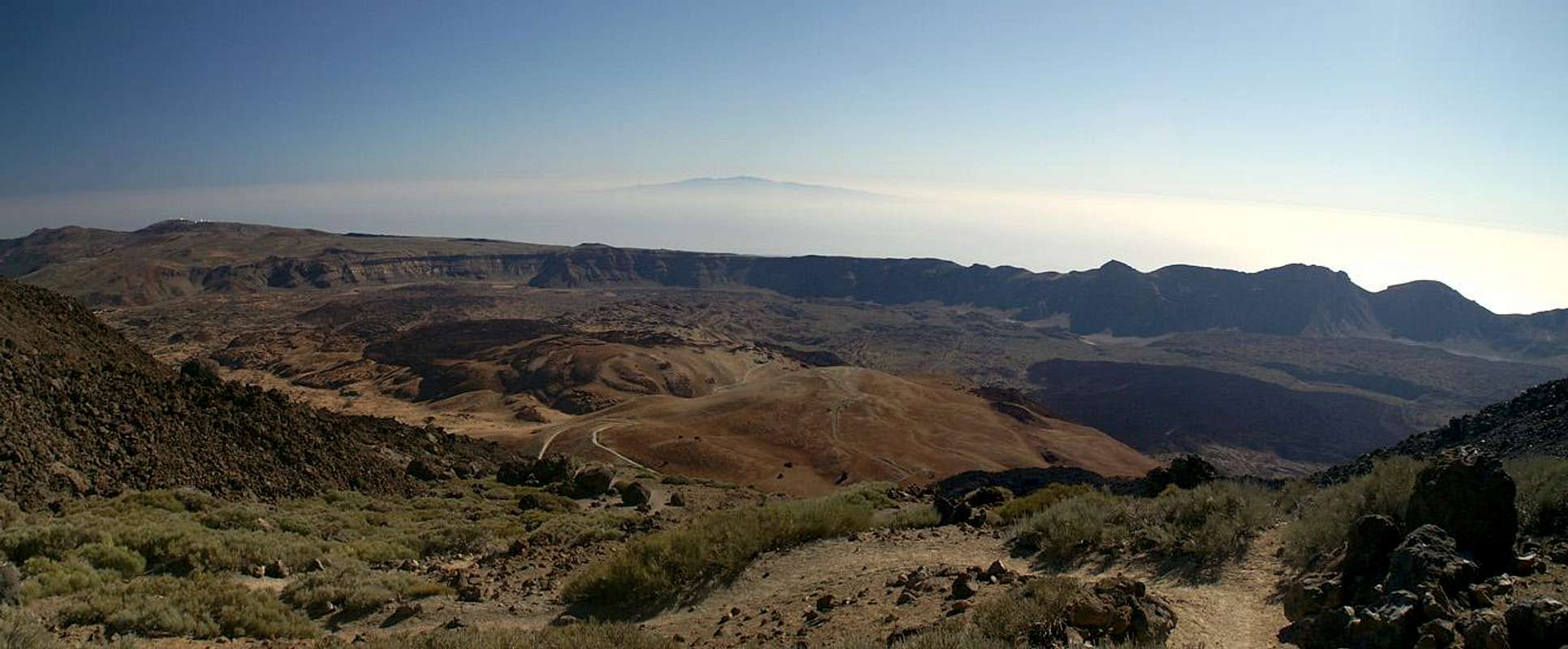 |
In the centre of Tenerife, at the base of mighty Teide, you can find a giant crater, Las Cañadas del Teide. It has a diameter of 17km and a circumference of 48km. Its base is located at an average of 200m – 2100m while the surrounding summits reach 2300 – 2700m. The northern part of the crater is buried under the huge cone of the Teide / Pico Viejo Stratovolcano.
The Cañadas are one of nature’s real wonders. Thanks to the fact that rain clouds barely make it that high the crater is as dry as a bone. Only few hardy desert flowers bloom there, among them the beautiful 2m high Tajinaste del Teide and the white Teide gorse bushes. Then you find some large lizards but that is all life has to offer in the Cañadas.
Three quarters of the caldera rim are still standing. Mountain follows mountain and at the southernmost point there is the tallest one of them all, La Guajara. Like all rim mountains Guajara has a vertical face to the inside of the crater while on the outside shallower slopes prevail. To the west of Guajara the mountains decline again with the second highpoint of El Sombrero (2532m).
The inside of the crater is divided in two parts (plains) at the intersection of which you can find the bizarre Roques de Garcia, basalt towers and lava walls. The eastern plain, Cañada de la Grieta, is filled with a jumble of lava fows, which have come down the south-eastern slopes of Teide. The lava forms huge walls and the plain is completely inaccessible.
To the west of the Roques de Garcia you find the sedimentary plain of Llano de Ucanca. The few raindrops which fall onto the surrounding mountains wash down all sand and dust and deposit them in the Llano, which consequently gives the impression of a desert. At its western end another lava flow, this one from the Narices del Teide, a side crater of Pico Viejo, bars the way, forming a smaller but nevertheless similar jumble as the one of Cañada de la Grieta.
To the north, at the western base of Pico Viejo, you can find about a dozen of lateral volcanoes. These cones all have erupted only once, filling the whole area with black lava cinder. It also is a magical site, especially where a bit of life breaks through the surface. This area slowly drops down towards the Teno Range in the north-west of the island.
Narcises del TeidePico ViejoPico TeideRefugio AltavistaMontaña BlancaTeide trailheadCable-CarRoques de Garcia 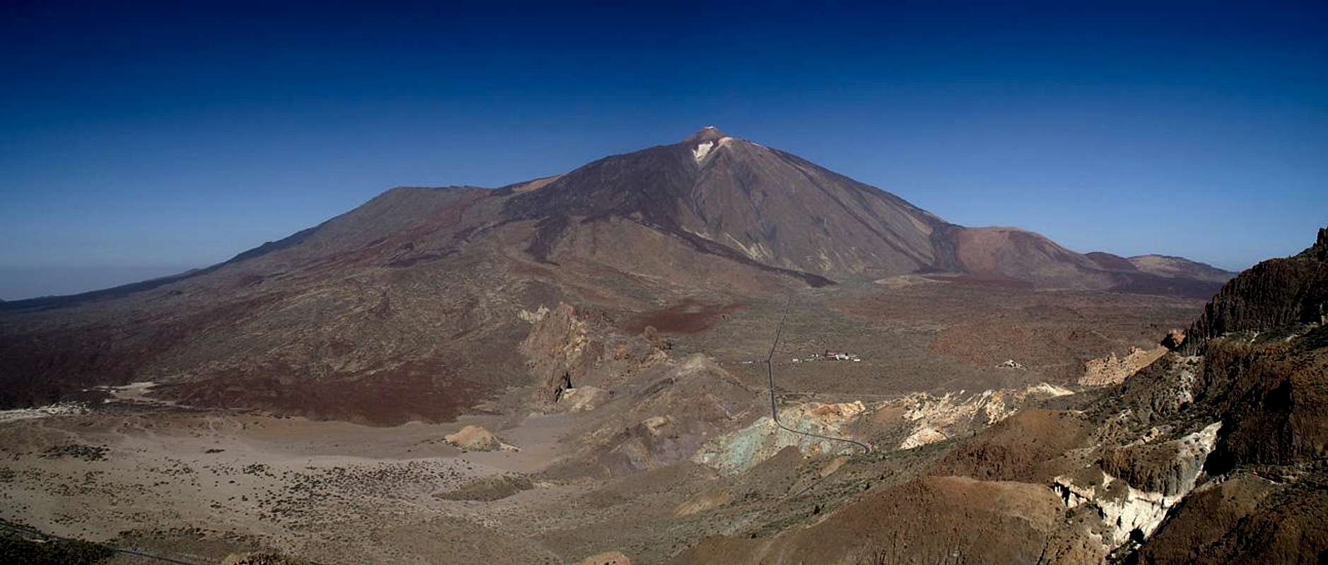 Hide / Show labels |
And then there is Teide. It is the highest mountain of Spain, a huge stratovolcano with several lateral craters. The largest one of these is the old peak, Pico Viejo, which has one of the largest and most colourful craters on all the Islas Canarias. At a diameter of almost 1km the circumference reaches 3km. Teide itself has only a small crater, right on to of Pan de Azucar, the sugarloaf, the youngest part of the mountain. Teide is still active as can be seen from the sulphurous emanation which regularly whiff of the summit. The mountain is accessible by two routes, the easy normal route across Montaña Blanca and Rifugio de Altavista and the impossible Pico Viejo Route from Bocca Tauce, the south-western gate of the Cañadas (impossible because you have to climb more than 500m in cinder ash). Most visitors, however, take the cable car, which leads up to La Rambleta, the base of Pan de Azucar. To climb to the Teide summit you need a permit, which is only issued at the island capital of Santa Cruz.
9 - Traffic and Accommodation
 |
As one of the major European vacation getaways Tenerife can be reached from all major European airports. From Spain there are regular flights from the rest of Europe you can book lots of charter flights. On Tenerife there are two international airports, one at Santa Cruz in the east, one at Los Abrigos in the south.
Accommodation also is not a problem. You can book endless numbers of hotel rooms, apartments or fincas from any travel office. Camping, however is not very common on the island and is not allowed in any of the nationa, regional or natural parks. The south coast of the island is very touristic with huge ugly hotel complexes right close to the beaches. The north coast is different. While you still meet a lot of tourists there they tend to stay in apartments or fincas so that hotel blocks and urbanisations are still uncommon. In the Anaga and Teno areas you will search for accommodation in vain. At the coast there are some smaller complexes (at Buenavista del Norte or Punta del Hidalgo) but in the mountains the local inn might offer the sole overnight accommodation.
10 - Red Tape
All the mountainous regions are protected as national or regional parks. The strictest rules apply to the Parque Nacional de las Cañadas del Teide, where almost anything is forbidden or restricted. No overnight stay, no leaving trails and paths, no pets, no plucking of flowers – the list goes on and on. The park rangers oversee that the rules are observed but they fight a difficult war against the hordes of tourists. The strictest application of the rules will be observed on Teide (also on the normal route) where rangers can be found all day. To climb to the Teide summit you need a permit, which is only issued at the island capital of Santa Cruz. Also at the Roques de Garcia there will be occasional supervision.In the other mountain ranges the rules are similar. However, since nobody watches over the observation of those rules you will be able to get away with more. In the Teno Range the entrance to Barranco de Masca is monitored in the Anaga Range I didn’t see any such monitoring.
11 - Weather Conditions
There are several sites on the web which give you information on the weather on Tenerife. However, they all show the weather for the coastal regions (Puerto de la Cruz) which significantly differs from the weather in the Cañadas del Teide or the Cumbre Dorsal which are 2000m of elevation higher. The following table shows data for Puerto de la Cruz on the coast.| Month | Jan | Feb | Mar | Apr | May | Jun | Jul | Aug | Sep | Oct | Nov | Dec |
| Avg. day temp.[°C / °F] | 19 / 66 | 19 / 66 | 20 / 68 | 21 / 70 | 22 / 72 | 23 / 73 | 24 / 75 | 26 / 79 | 26 / 79 | 24 / 75 | 22 / 72 | 20 / 68 |
| Avg. night temp.[°C / °F] | 13 / 55 | 13 / 55 | 14 / 57 | 14 / 57 | 16 / 61 | 18 / 64 | 19 / 66 | 20 / 68 | 20 / 68 | 18 / 64 | 17 / 63 | 14 / 57 |
| Water temp.[°C / °F] | 19 / 66 | 19 / 66 | 19 / 66 | 19 / 66 | 20 / 68 | 20 / 68 | 22 / 72 | 23 / 73 | 22 / 72 | 22 / 72 | 21 / 70 | 20 / 68 |
| Rainy days | 10 | 7 | 8 | 4 | 3 | 2 | 1 | 1 | 3 | 5 | 7 | 9 |
The Canarian Islands (as well as Madeira) are located in the trade wind zone. You almost always encounter north-eastern winds which carry a lot of humid air. Being forced to climb to higher altitudes this moisture condenses into clouds. This in return means that most of the time the northe-astern part of the islands is covered in clouds from altitudes of 1000m through 2000m.
The mountains themselves - being mostly of the same altitude - finally stop the clouds so that on their south-western slopes the clouds "run out". In the case of Tenerife the Cumbre Dorsal is about the elevation the clouds reach so that you might be disappointed with respect to views. The Cañadas usually are above the clouds while Anaga and Teno regularly drown in fog. The Adeje region, on the other hand, almost always is dry and sunny.
12 - Maps & Books
12.1 – Maps
It is very difficult to obtain good hiking maps for the Islas Canarias. The best ones I found are the ones by Kompass Verlag but they are far from perfect. In some of the regions there are serious errors. Kompass’ Tenerife map is the best of the bunch. Some hiking routes are missing but overall the map is adequate.
- Teneriffa / Tenerife
Kompass Map WK233
Kompass Verlag
ISBN: 3-85491-038-X
12.2 - Digital Maps
Kompass is the only company known to me which offers GPS digital Maps. In addition for those of you with Garmin GPS receivers there is a map source map set of all Canarian islands out there with the exception of Lanzarote. Currently you can download it for free.
- Teneriffa / Tenerife
Kompass GPS4233
Kompass Verlag
ISBN 3-85491-218-8
- Islas Canarias
Map Source custom map
By Manfred Pepper
downloadable zip-file
12.3 – Books
An excellent hiking guide available in both German and English is:
- Teneriffa / Tenerife
Klaus Wolfsperger / Annette Miehle-Wolfsperger
Rother Verlag
ISBN 3-7633-4016-5 (German)
ISBN 3-7633-4809-3 (English)