Getting to BSP
This trip was a Bowdoin Outing Club trip, it was an open to anyone who had paid the membership fee and limited to the first nine people to sign up. Fortunately, when the trip sign up closed, just three other people signed up for the trip and two of them, Annabel and Emma, are good friends whom I know to be experienced hikers and good company. The group met on Thursday to go over route plans, what to pack, and learn each other's names. The other person who had signed up stopped by to let us know he wasn't coming because of the 90% chance of heavy rains while we were supposed to be on the mountain. This cut the group to six, three of us and three BOC student leaders: Andrew, Renny, and Sam. Andrew had been backpacking with Emma, Annabel and me in August but none of us had met Renny or Sam before. We talked briefly and then split up planning to drive up on Friday, wake up early Saturday and hike to Chimney Pond and summit from there, then return on Sunday around midday.
On Friday, I made it to the BOC headquarters just as it started to rain, a rather fitting start to the trip. We piled into a minivan and headed out of Brunswick around 3:30. The rain stuck with us until just south of Millinocket but it remained overcast all the way to Baxter SP.
The ranger at the Roaring Brook campsite checked us in and directed us to our lean-to. He also mentioned that we should strongly consider hiking South Turner Mountain instead of Katahdin due to the heavy rains that were on the forecast for Saturday. He also mentioned that High Bridge (just east of Chimney Pond) was out and that it might be impossible to even get to Chimney Pond, much less get up the mountain. With that in mind, we looked over the map. Sam, Emma and I had never been to Katahdin before, Renny had climbed Katahdin several times but not recently, Annabel had done it about five years ago and Andrew had climbed it in winter, but none of us had been up it in the fall for several years. We relied on our best judgement to determine alternate routes. We figured that Hamlin Ridge might be our best bet if Chimney Pond were inaccessible, we also considered just going up and down Cathedral to minimize the amount of time we spent above treeline.
At 4:30 AM on Saturday our alarm went off. We sat up, looked at the darkness outside the lean-to, listened to the rain, then got dressed and quickly checked our packs. After waking up the leaders and eating a breakfast of cold bagels and jelly, we left the site, clad head to toe in Gore-Tex and wearing our headlamps.
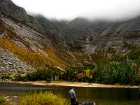
![Chimney Pond]()
Renny signed the Roaring Brook ranger station's trail registry at 5:50, putting down Hamlin Ridge as our intended route. We were the first ones out of Roaring Brook that day. We walked along in silence, a line of dark shapes topped by bobbing dots of light, each of us left to our own thoughts. Twenty minutes later, we stopped to change layers, despite the chill and rain, the hiking warmed us up quickly. I took off my softshell vest and neoprene biking sleeves. Visibility increased gradually and we were able to turn off our headlamps a little before 7. Just after that, we spotted a young moose a few feet off the trail. We stopped and stood there in the rain watching it munch on some plants. Even though it wasn't full grown, we were still struck by how
big it was. It was the size of a horse, and a large one at that.
When we got to the "CAUTIION" tape across the trail, marking the unpassable High Bridge, we turned right and followed the trail that we thought was the detour the ranger had mentioned. This turned out to be a mistake because instead of leaving the official trail and then rejoining it 100 yards further down, we took a different trail all together. We realized this when, instead of arriving at Chimney Pond 20 minutes later, we found the North Peaks Trail junction. At that point, we just followed the signs to Chimney Pond so that we could check in with the ranger at Chimney Pond, then head back out to Hamlin Ridge. We later learned that our "detour" had added over a mile of extra distance to our hike as well as ascending and then descending 300 needless feet.
Who listens to the voice of reason?
We arrived at the ranger station at 8:00, just before a huge group from New Brunswick. They were loud and underequipped, wearing jeans and tee shirts. Five of us went to a nearby lean-to to change our layers and get out of the rain. Renny talked to the ranger who said we shouldn't be above treeline but said if we were determined to summit anyway, we should take the Saddle Trail. Again, Renny signed us in, but put Saddle down as our intended route. In the mean time, we tried to get rid of wet layers but that turned out to be everything we wore. I ended up taking off my shell, sleeves, wicking shirt, rain pants, and hiking pants. In short, I was basically naked (I had on running shorts and hiking boots) as I vainly squeezed water out of my shell and shirt. When I got dressed again, I put away my shell and rain pants since the shell was soaked and the pants which, while 100% waterproof, have zero breathability and were soaking my hiking pants. I ended up wearing my hiking pants, TNF Elixir vest, neoprene sleeves, and Epsilon SV jacket. Fortunately, we made it out just before the New Brunswick group. The Saddle trail leads up the eastern side of the basin in between Baxter and Hamlin and it isn't too steep at the base, but the last half mile is very steep and goes up a rocky trough. It doesn't get technical, just steep. The rain made the rocks slick but there was nothing too bad.
Up on the Saddle, we turned left and headed up towards Baxter. Had it been a clear day, our views would have been phenomenal had it been a clear day. We trudged along towards the summit and saw two or three other groups on their way down, they had come up the other side of Katahdin. My pants soaked through and I gave up on ever feeling anything but cold and wet. On the summit, we found five of six people already there. One, a thru hiker, was celebrating his completion of the AT by sprinkling a special Native American tobacco in the wind. (If you're reading this and you are that hiker, congratulations on hiking the AT and well done for celebrating with class and respecting everyone while doing it.) We didn't spend much time on the summit because as soon as we stopped, it got cold. Sam and Renny checked the map and looked down the Knife Edge and thought it wouldn't be too bad. We all agreed that, since we had time (we summited before 11) we would descend the Knife Edge instead of Saddle.
![Knife Edge]()
We started down the ridge after snapping a single picture of the summit. Somewhere between the Tableland and the summit, we left the rain and entered the clouds. The wind was coming out of the southwest and zooming up the side of the ridge to hit us as we scrambled along the top. We unknowingly hit South and Chimney Peaks as we went along, but the mist kept us focused on our immediate surroundings. It was really cool to hike along the ridge knowing that there was a huge drop on either side of us but not be able to see it. We made steady progress along the ridge and made it up the one extended difficult stretch without any problems. I honestly can't tell you where the spot is on the ridge, but you head down rather steeply to a short flat spot where a goat trail meets the Knife Edge trail, then go right back up an angled rock face. There are easy holds and its probably Class 3, but with the slick rock and being cold, wet, and tired, it was a nice challenge. We made it to Pamola Peak without incident. All of us slipped on the rocks, but we were smart enough to fall on the wide spots and not fall far. The Knife Edge is a great trail, possibly my favorite. It is challenging and was impressive. The views would be excellent if the weather is clear, but the tendrils of mist sweeping over the rocks was a sight to behold.
Down and Out
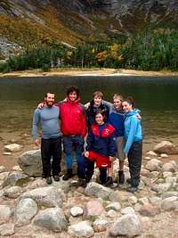
All the way from Baxter to Pamola I felt pretty cold and miserable. But once we got down off of Knife Edge and out of the wind, we started warming up and drying out. Just below Paloma, the clouds cleared briefly and we got a great view of a pair of ponds off to our right and the basin on our left, those who had cameras handy took some pictures before the clouds closed us back in. We took a lunch break halfway down the slope at a flat spot in the boulders. I zipped off my pant legs and finished the hike in just the vest and short. We moved fast after that, stopping by the lean-to at Chimney Pond to pick up the wet baselayers we had left there and take a group picture. I looked at the rain gauge outside the ranger station, it was at 3.5 inches when we were there before, and it was over seven inches.
![Group picture]()
We checked the registry, we were the only ones to descend Dudley trail (Pamola to Chimney Pond) that day. We took the direct route back to Roaring Brook, going right over the bridge that we were told was impassible. We discovered that the detour we took that morning had added at least an hour to our trip unnecessarily. The ranger said that some stringers were being replaced and it amounted to a 15 foot section without any logs to walk across, so we just walked across the complete section then stepped over the latticework in the gap.
From there on out, we just moved quickly. If anything, the trails were better than they were on the way up. We actually got to see Roaring Brook which we couldn't see that morning. The stream was very pretty with the yellow and orange maple leaves floating in it. We made it back to Roaring Brook just before five. Fortunately, we were all dry by then and didn't need to bundle into the car and crank the heat like we were considering up on the Knife Edge.
Learning Experience
This trip, apart from being a great hike, was a good learning experience. I learned that my Osprey Atmos 25 is a great pack, good size and capacity, for trips like this and that it soaks through when in heavy rain for more than two hours. I learned that my old REI rain jacket soaks through quickly, but that brand new, top of the line Gore-Tex soaks through too. I learned that garbage bags are good for use as waterproof vests (well done Emma for thinking of that). I also learned that garbage bagging your spare layers is always smart. More importantly, I learned that with the right people, a hike that was largely cold and wet and 11 hours long can be a lot of fun. Next time I'm hiking on a mountain with a 90% chance of torrential rains, I'll skip the rain coat and just cut up a garbage bag. Anybody with advice or anecdotes is more than welcome to comment. In fact, I would greatly appreciate it. Thanks and happy hiking.


Comments
Post a Comment