Katahdin, the 7th Highest in Northeast
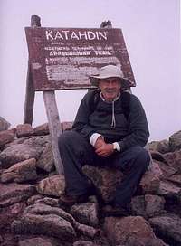
![Self Portrait atop Katahdin]() At the Summit
At the SummitKatahdin is the highest point in Maine at 5267 feet. From trail hiking head to peak and return it is 10.4 miles. Elevation of hike is 4300 foot incline. I would rate this hike as the most difficult I have done to date. I have hiked the high points of Colorado, Mount Elbert, 14433 ft; New Mexico, Mount Wheeler, 13161 ft; Arizona, Mount Humphreys, 12633 ft; and Texas, Guadalupe Peak, 8749 ft. None of these were as difficult as Mount Katahdin. It was more of a climb than a hike. From beginning to end you were hiking over small boulders or climbing up big boulders. At one point the boulders had iron rungs that had to be used to traverse them. The morning of the hike we arrived at the gate to Baxter State Park around 4:30am believing that the gate opened at 5:00am only to find out that it opens at 6:00am. We took advantage of the mistake in time by eating some energy bars and fruit, then washing it down with a soda. We were first in line when the gates opened.
The morning was beautiful. Temperature around 60 degrees and clear skies. We filled our backpacks with snacks and water for the hike. Started out about 6:50am. I was going to take my hiking sticks along, but we were hiking with a friend who had already hiked Katadhin twice. His advice was not to take them as they would get in the way when we climbed over the boulders. I left them at the camp site, a decision I would later regret very much when it came time to hike back down the mountain.
The first mile of the trail was fairly easy and the terrain beautiful. On one side of the trail was a rushing creek, spilling over big boulders. The water was crystal clear. This same stream is used by the Baxter State Park campers for drinking water. Baxter State Park has no tap water or electric. The only facilities at the part for those who camp is a basic toilet. Radios are not even allowed. It is very primitive camping.
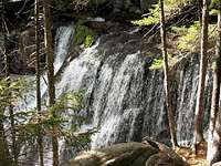
![Katahdin Stream Falls]() Katahdin Stream Falls
Katahdin Stream Falls
Along the other side of the trail were wild flowers, such as bunch berries, blue barriers, lady slippers. About one mile along the trail there is a water fall on the right hand side.
![Bunch Berries]() bunchberries
bunchberries![Lady Slipper]() Lady Slippers
Lady Slippers
It looked so refreshing that I wanted to take a drink and put some cold water on my face.
Once you pass the water fall the trail begins its steep accent. At first the boulders are small and strewn all up the path. As you climb further up the trail the boulders become larger. A place on the path called Gateway is where the really big boulders begin that requires climbing. It was at here that you have to climb using iron rungs to get up the boulder. We nearly turned back at this point in the trail. The sun had given way to fog and a 50 mile an hour wind. The temperature dropped to about 40 degrees. I had a sweat shirt on, but no gloves. My hands were cold and I was shivering.
Once up over the first big boulder there is still nearly two miles to the top. Much of this part of the trail is over huge boulders, a missed step and you could fall off the side of the mountain or with the strong wind I was afraid of being blown off the mountain.
![Iron rungs area]()
[Our seasoned Katadhin hiking partner assured us that once over the Gateway boulder the winds would not be so bad. We decided to proceed. He was correct. The fog stayed, but the winds subsided. Then I looked up at the trail ahead and wished I had turned back. As far as the eye could see there were huge boulders to climb. My knees were already hurting, but we were nearly half way. Once I make up my mind to do something it becomes a driving force in my life. It becomes something I have to do. With my hiking partners setting the pace and in the lead I trudged on. At some time during each hike there comes a time or part of the trail that seems to be very discouraging. I just know that if I get past that point in the trail I will be okay. This is what I saw ahead of me.
Once we hiked over the boulder field the trail evened out for a bit. There was a plateau for a while. A big reprieve for my aching knees. Near the end of this fairly level part of the trail there is a sign by a moist spot in the trail naming it Thoreau’s Spring. Near the spring there is a sign on the rocks indicating it is another mile to the top.
From Thoreau’s spring it starts a gradual incline to the peak. This part of the trail, though not as steep, is still strewn with small boulders that you have to walk over. Finally through the fog I was able to see the peak. Then finally I was there. I had made it.
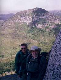
![Group pic top Katahdin]() We did it!!
We did it!!
After taking a few pictures, a snack and rest we started down. I guess the small rest didn’t help my knees. I could barely walk. The pain was terrible. I told my hiking partners I didn’t know if I could make it back down, but the only choice I had was to hike back down the same trail we had come up.
One of my hiking partners had Advil. I took two of them. It was slow going and painful. The sky had cleared. The views were awesome, but I could barely see the view through the pain. I plodded on this seemingly endless trail. If only I had brought the hiking sticks to relieve some of the pressure on my knees.
Going back down over the boulder field, to save my knees, I tried sliding down them on my rump. It did help some, but in doing so I had to use my hands on the rough boulders. They eventually got sore from the rough rock. At the end of the boulder field we found a stick that I used for the rest of the hike down.
We finally finished the hike at 6:30pm. We were staying at a camp site in the park for the night. I could not do much but watch my partners pitch the tents and set up our camp. We had a great meal prepared by our seasoned Katahdin hiking partner. This was my first attempt at camping. I like my hot water and electric, but the sleeping bag really felt good that night.
This was a two in one trip. First and Last.


Comments
Post a Comment