
-
 3959 Hits
-
 83.1% Score
-
 16 Votes
|
|
Mountain/Rock |
|---|---|
|
|
44.26487°N / 115.16448°W |
|
|
Boise |
|
|
Hiking, Mountaineering, Scrambling |
|
|
Summer, Fall |
|
|
9321 ft / 2841 m |
|
|
Overview

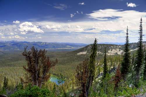
As the highest point in the Sawtooths north of McGown and for a 16 mile stretch
of ridge line, Kelly Point 9321 makes an interesting scramble, in terrain often
overlooked for the larger peaks in the greater Sawtooth Mountains. The
major spine or ridge line that extends from Observation Peak north to
Copper Mountain includes many interesting high points with unique and
terrific views. Kelly Point is the highest point on this entire ridge line and is
well worth the scramble. There are little known, yet highly scenic lakes,
trails, and rocky high points in this region. There are many interesting
approaches to Kelly Point and because of it's location in the northern tip of
the range access from the east, west, or north is possible.

Kelly Point lies on the exact dividing line of both Boise and Custer counties,
and the dividing line of both Challis and Sawtooth National Forests, so
determining where exactly it would be classified would be up for debate. If
approached from the Banner Summit area (north) the trail follows the Bench Creek
valley up to a magnificent pass before the trail drops down to Marten Lake. From
the Pass area, one follows a rugged ridgeline south to reach the summit. If
approached from the east and the Trap Creek area, the trail follows a beautiful
meadow before reaching the aforementioned Pass above Marten Lake. If approached
from the west via the North Fork of Canyon Creek, the scrambling is shorter, but
much steeper with no official trail to follow. Regardless of the approach, Kelly
Point is a rewarding scramble with a relatively short drive approach from the
Boise area.
Routes
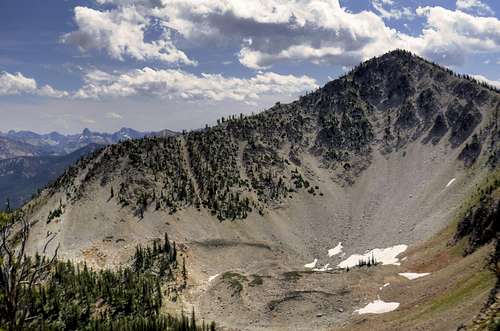
Bench Creek from near Banner Summit (Class 2): Park at the Bench Creek Rest Area and cross the highway. Take the Bench Creek trail as it gently climbs for the first few miles. Before the summit, the trail steepens dramatically. At the summit enjoy the view of Marten Lake and leave the trail and climb the ridgeline south staying mostly on the ridge proper with brief visits to the west side to avoid small rock towers and drop offs.
6.6miles and 3184 feet gain (one way)
Round Trip Time Estimate: 4-6 hours
Trap Creek from Blind Summit (Class 2) - Park near Blind summit and find the Trap Creek trail as it climbs gently to the Marten Lake area. From here, the trail steepens drastically before reaching the pass. From the pass follow the standard ridge line traverse as described above.
7.2miles and 3312 feet gain (one way)
Round Trip Time Estimate: 5-7 hours
North Fork of Canyon Creek Approach (Class 2) - Park near a prominent opening in an otherwise steep narrow canyon off ID-21. If coming from the Boise area, the parking area is shortly after ID-21 crosses Canyon Creek and the creek is on the left (west side). Hike up the prominent Canyon and after 3 branches of tributaries enter the main canyon (these are on the left or north), find the prominent ridgeline that goes to the Point just south of Kelly Point- Point 9051. This point is about 0.7 miles from Kelly Point. Follow the rocky ridgeline north to the summit.
3.4miles and 3495 feet gain (one way)
Round Trip Time Estimate: 4-6 hours
Conditions

Latest Avalanche Report (Sawtooth Area)
http://www.avalanche.org/~svavctr/
National Weather Service Current Forecast for Stanley:
http://newweb.wrh.noaa.gov/total_forecast/index.php?wfo=pih&zone=idz018&fire=idz406&county=idc037
Sawtooth Web Cam can give you a good idea of the conditions in the area:
http://www.ruralnetwork.net/~dpinney/
Sawtooth National Recreation Area
http://www.fs.fed.us/r4/sawtooth/recreation/recreport.htm
SNOTEL site gives latest snow depth readings:
http://www.wcc.nrcs.usda.gov/snotel/snotel.pl?sitenum=312&state=id
