
|
|
Mountain/Rock |
|---|---|
|
|
43.43089°N / 16.73086°E |
|
|
Splitsko-dalmatinska county |
|
|
Hiking, Sport Climbing |
|
|
Spring, Summer, Fall, Winter |
|
|
2831 ft / 863 m |
|
|
General survey
 View from Kula due southeast
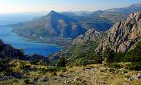 View down to the trailhead start
There are no striking or dramatic, just several interest arousing moments regarding Kula
- it's position - it is last prominent point on the southeastern end of the undulated mountain ridge, thus offering extensive views
- it's surroundings - whole mountain is steep-sided and limited by Cetina river canyon on the north and northwest (canyon crags are popular climbing site)
while south and southwest section of the mountain gradaually sinks into the Adriatic sea. On the southeast end, Kula enjoys commanding view accross long hogsback of mt. Rogoznica, untill distant mt. Biokovo finally terminates the horison on that end.
Routes: Normal and common route is about 3 hours walk-up with moderate scramble in the end.
From town Omis at the westside foot of the mountain, follow the paved road uphill to nearby Borak village.
Here, fork left following the waymark uphill, on the righthand slope of Fortica summit.
Fortica is westernmost prominent summit on the Omiska Dinara main ridge.
On the top of it, there is large medieval fortress. Short 15 minute deviation due left at the first trail junction, takes you there.
The fortress is kinda of panoramic point on its own, views spanning from the mt Mosor on the NW, accross the Cetina canyon,
mt Mosnica,Brac channel till the islands of Solta and Brac. From here, one may continue main ridge traverse due east,
ascending over summits of Gavranovo gnijezdo (Raven's nest), Imber and Strazine toward Kula (3-4 hours)
or back to the trail junction, from where path continues due east, contouring the rocky east face of Omiska Dinara,
first through the pine woods, then accross the scree field, slightly ascending all the time until it steepens up the wide rocky col
and catches with righthand edge of the thick pine forrest, untill it reaches the small plateau with bivouac and water source.
From the plateau, goats path forks left uphill to the main ridge and finally steepens up a bit more untill reaching
the summit of Kula, marked with small stone cairn and even smaller wodden cross fixed on top of the cairn.
Summit register is 4 yards to the right of the cairn. Return the same way or by ridge traverse mentioned above.
Some additional notes:
- ridge traverse is more panoramic and more exposed to the sun. Normal route is less panoramic, but also less exposed to the sun.
- It is possible to descend down the north side of the mountain into Cetina kanyon (steep) as well.
But then you'll have to walk miles back.
- Current normal route runs tad beneath the old one. Leftovers and marked waysigns from the old route are still visible,
but there is no point to try this one as it does not earn any time, and is also subject to rockfalls
(rockfalls on the Omiska Dinara are not uncommon).
- elevation gain equals total elevation, thus 863m/2831f
- don't forget sturdy boots
Getting there
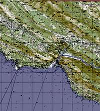
 Road access map
- As
said, Kula is the highest summit of Omiska Dinara.
And Omiska Dinara is backyard mountain of town Omis, old piratic stronghold in the middle Dalmatia, on the mouth of the river Cetina.
- getting
there by train: Nearest train stop is Split, 30km or so to the NW up
the Dalmatian coast
Train station is close to Split bus terminal - by ferry: Nearest intl port is Split.
Regular ferry lines to/from Ancona/Italy, Igoumenitsa/Greece,
Rijeka/Croatia.
Port is close to Split bus terminal. - by
coach: there is no bus terminal in Omis. However, all coach services
from Split toward east (direction Makarska, Imotski or Dubrovnik) and
vice versa, stop at Omis. Coaches and busses normally stop
near the city centre, next to the Omis harbour and Fire brigade station.
They'll also stop on demand, if you want to get off at the bridge at Cetina river, for example, just ask the driver.. Split bus terminal is located both close to the port and to the railway station.
Split bus terminal timetable in English
Same Split-Omis route is also served by suburban bus line no.60. - by plain: nearest Airport is Split international timetable in English. From the airport, direct coach service for Split bus terminal where, again, switch to any coach departing due east (Imotski/Makarska/Dubrovnik) or board on city bus no.60.
- by
car: from North or NW (Austria, Slovenia, Hungary) A1 Zagreb-Split
motorway till Split, then catch D8 subadriatic arterial due east for
Dubrovnik. A1 suffers from traffic bottlenecks in high summer season,
some section of it may be closed in winter in case of strong bura wind.
Alternatively, you can drive down the old D1 via Plitvice lakes (no
road tolls, and usually no bottlenecks). Split-Omis drive may
take anywhere from under half an hour, up to 2 hours in high mid summer
season.
Road conditions info
Climbing info
Rock is limestone, around 80 sport climbing routes on half dozen different crags, mixed single&multi pitch, bolts.
Few words about the crags; 3 of them belong to the Omiska Dinara mountain proper, Peovo, Planovo & Babina bara.
Peovo is located at the SW end of the mountain, just above the Omis oldtown and behind the Mirabela fortress. Easy10 minute uphill srtroll
from the oldtown.
Planovo is located on the western end of Omiska Dinara, on the other side and behind the tunnel through which road from Omis into the Cetina river canyon goes.
Pass the tunnel and look to your right. Car parking beneath the crag. You can walk from Omis as well, 15 minutes or so.
Babina bara is located tad further due north from Planovo. Pass the 2nd tunnel on the same road, fork right following the road that leads toward Sarina island and Radman's mills, and again look to your right. Possible car parking.
Stomorica and Babjaca are lateral ridges of mt. Mosnica, located right accross the Omiska Dinara and mouth of Cetina into the Adriatic sea.. To get there, cross the bridge accross Cetina due east (direction Split) into Vukovarska street (new and less pretty part of Omis). Crags are easy to spot from everywhere in Omis, beach included.
Ilinac is most remote out of all crags. It is the southernmost wall of mt. Mosor. Again, cross the bridge into Vukovarska street, fork right, pass aforementioned Babjaca and nearby camping site, then drive into the Cetina canyon by the western bank, due north direction Zakucac hydro power plant. As you drive, all 3 crags of Omiska Dinara proper will be on your right, accross the river. Park your car before the power plant and proceed on foot due north, pass the bridge on your right, from here another 10 minutes to the crag. Below is small and very likely outdated routes summary for each crag, difficulty indicated in French grades.
For grade comparison, please, see here
| P e o v o | |||
|---|---|---|---|
| Number of routes | Difficulty (French grades) | Shortest route lentgh | Longest route lentgh |
| 9 | 6a+,6b, 6b+,6c,6c+,7a,7b+ | 14m/46f | 24m/79f |
| P l a n o v o | |||
|---|---|---|---|
| Number of routes | Difficulty (French grades) | Shortest route lentgh | Longest route lentgh |
| 34 | 4a to 7a+ | 10m/33f | 40m/131f |
| B a b i n a b a r a | |||
|---|---|---|---|
| Number of routes | Difficulty (French grades) | Shortest route lentgh | Longest route lentgh |
| 7 | 6b,6c,+,7a,7b,7c,8a | 10m/33f | 33m/108f |
| S t o m o r i c a | |||
|---|---|---|---|
| Number of routes | Difficulty (French grades) | Shortest route lentgh | Longest route lentgh |
| 4 | 6a+,6b,6c | 20m/66f | 100m/328f |
| B a b j a c a | |||
|---|---|---|---|
| Number of routes | Difficulty (French grades) | Shortest route lentgh | Longest route lentgh |
| 11 | 4c to 8a+ | 14m/46f | 150m/492f |
| I l i n a c | |||
|---|---|---|---|
| Number of routes | Difficulty (French grades) | Shortest route lentgh | Longest route lentgh |
| 3 | 5c,6b,6b+ | 220m/722f | 300m/984f |
Relevant and more up-to-date links:
Omis climbing portal (good info, but you may find youself fighting the layout of that page)
Details on Omis/Cetina canyon climbing area, at Dalmatia climbing portal
Pics: Some dudettes about to climb Planovo, on top of Ilinac, Rambo route on Ilinac - photographer Vicenco Bartulin
More info on Omis climbing area at climb-europe.com
Accommodation
 The Imber bivouac
2** camping "Lisicina" in Omis, left Cetina river bank, close to the climbing crags
website with contact details and essential info
3** camping "Galeb", again close to the town and climbing crags and next to the beach as well.
Camping Galeb website with plethora of info
Nearest hut is Imber, small wooden bivouac nailed to the nearby rock on the 20x20 metre size grassy plateau beneath the Strazina summit.
Unshielded, unlocked (bar only, please pull and close the door when you leave) no beds or bunks.
Basic facilities inside include stove, first-aid kit, cooking facilities, 3 benches and one wooden table. Water source, just to the left behind the bivouac.
From here, go left and uphill following the marked goat trail for 25 minutes or so,
then 10 minutes of easy scramble and some rock-on-rock hopping to the Kula summit
Red tape / Weather / Maps / Security
 Detailed topographic map of the area
Weather:
Kula, Omiska Dinara and Omis climbing area have typical mediterranean climate.
Best times of the year both for hiking or climbing are either spring or autumn. Winters are ok.
Summer is hot, still for a half-day hike not inadequate. Climbing crags, those 3 inside Cetina canyon are more pleasant,
however canyon itself is sometimes quite windy ( sam goes for Paklenica, for that metter).
Crags to the left of the Cetina river are exposed to the sun.
Meteo stations closest to Kula are in nearby towns of Split and Makarska.
Split 7 day weather forecast
Maps & books:
Supplied large scale maps should be more than enough. There was never extra map/guide issued, covering Kula or Omiska Dinara only.
Book: Croatia Climbing Guide, summer 2007. Earlier edition review over at Summitpostgear
Omis climbing area is featured inside, from the 1st edition onwards
Security:
Emergency mountain rescue, dial 112