
-
 16265 Hits
-
 82.48% Score
-
 15 Votes
|
|
Route |
|---|---|
|
|
38.27269°N / 109.995°W |
|
|
Hiking |
|
|
Spring, Fall, Winter |
|
|
Half a day |
|
|
about 2000 ft. elevation change |
|
|
Overview
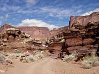 Lathrop Canyon Road
The Lathrop Canyon Trail goes from the main road coming into Island In the Sky, and goes down to White Rim Road just above Lathrop Canyon. From that point there is a 4-wheel drive road that goes down to the Colorado River, if you want to continue hiking on a road. The trail is 6.8 miles long, the road is 4 miles long. Unless you have someone to drive your car to meet you, or you hitch a ride, you will have to hike the trail round trip.
Hiking time should be between 2 and 4 hours up and 2 to 3 hours down. I started at White Rim Road, it took me 2 hours and 10 minutes to hike up and 1 hour and 55 minutes coming down, but I was trying to see how fast I could do it.
It is a fantastic trail, with extremely beautiful views, that climbs up the canyon wall. It kept me guessing most of the way as to which route it would take. I hiked from White Rim Road up to the top, and then returned down the same way, as a day hike. I also hiked down to the river and back on the Lathrop Canyon Road as a backpacking trip.
I forgot my camera for the hike, if anyone has pictures from the trail, please add them.
Getting There
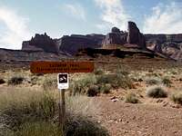 Lathrop Canyon Trail trailhead on White Rim Road
From the Island in the Sky Visiter Center, continue past the Shafer Canyon Overlook and the Neck Spring Trail. About 2 miles from the visiter center, there will be a sign on the left for the Lathrop Canyon Trail. There isn't really a parking lot there, just a parking lane along side the road. The other end of the trail is on the White Rim Road, which is a 4-wheel drive road that goes down in the canyon, from just before the Visiter Center. The start of the road is called the Shafer Trail Road. At (or after) the Potash Road, it is called the White Rim Road. Just before the Lathrop Canyon Road, there is a sign for the Lathrop Trail on the right side of the road. There is really no parking here, it is best to go a few hundred feet farther to the Lathrop Canyon Road, where there is room for a few cars to park.
It is also possible to get to White Rim Road from Moab by using the Potash Road, turn left when you reach the Shafer Trail Road. In this case you will need to get your permit ahead of time, I think it is possible to do this in Moab. I went in through the Island of the Sky and out on the Potash Road, which is shorter and quicker, with less bad 4x4 road.
Route Description
The trail starts in Greys Meadow and the first mile is a sandy trail across the meadow. From there the trail gets more interesting, first crossing an area of large flat boulders. After it goes over the rim, it becomes a fabulous trail with many hundreds of rock steps going down the canyon wall. Near the bottom of the wall, there are numerous old mines shafts near the trail. The ones I saw had been closed off with wire mesh. From this point, the trail follows an old road, probably a mining road. When it reaches the lower level it follows a dry wash until it reaches the White Rim Road.If you want to continue to the river, turn right on the road for a few hundred feet and the Lathrop Canyon Road will be on your left, there is a sign for it as well. There are picnic tables and an outhouse at the river.
Essential Gear
There is no drinking water anywhere in the Island in the Sky so you need to take plenty of water. When I was there (April 2008) the Visitor Center was selling gallon jugs of drinking water, for I think $1.59, even though the printed information says there is no water available. I'm not sure if they will continue do this or if they always have water there.There is no shade on the trail, so be prepared for this if you are hiking during the summer. The best times to hike are spring or fall, winter is OK if you don't mind cold weather. The trail could be dangerous if there were snow.
If you are used to hiking in low shoes or trail runners, they will be fine for the trail. Trekking poles would be good if you use them for going down hill as there is rapid descent on the way down.
Camping, Permits
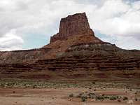 Airport Tower, near the campsite
There is a small campground called Willow Flat, which is located 6 miles past the Visiter Center in the Island of the Sky. No permit is needed but there is a nightly charge, I think it was $8 per campsite, self pay by envelope.
There are a number of primitive campsites, with outhouses, on the White Rim Road. There is no nightly charge for these but you do need to get a $30 permit at the Visitor Center. The permit is good for up to 7 days but you need to specify where you will be camping each night, either a specific campsite, or a general area for backcountry camping. The closest campsite to the trail is Airport Tower, which is about 5 minutes past the trail head by car.
The entry permit for the park costs $10 per car, or $5 per person if you walk in, and is good for 7 days.
No permit is needed to hike the trail or to drive on White Rim Road, if you do it as a day trip and do not spend the night in the canyon.