
|
|
Route |
|---|---|
|
|
38.45242°N / 109.82035°W |
|
|
Hiking |
|
|
Spring, Fall |
|
|
Half a day |
|
|
Hike |
|
|
Overview

Map
Neck Spring Trail is a pleasant 5.5 mile loop trail near “The Neck” in the Island in the Sky district of Canyonlands National Park. “The Neck” refers to a 40 ft wide isthmus that connects the Island in the Sky Mesa to the mesas to the north of it. Rocky walls drop down almost vertically on both sides of The Neck. The eastern walls go down more than 1000 ft to the bottom of Shafer Canyon. The western walls drop down only 150 ft to a lower plateau. The plateau is carved by two small valleys/canyons: Neck Spring Canyon and Cabin Spring Canyon. These two canyons head north/northwest and quickly join to form the Taylor Canyon whose walls go down 800 ft below the level of the plateau.
Unlike many other nearby trails that drop to the bottom of the canyons, more than half of Neck Spring Trail remains on the lower plateau and the rest of it on the surface of the Island in the Sky Mesa itself. The elevation difference between the lowest and the highest point on the trail is only 400 ft.
Getting There
From Visitor Center, drive 0.8 miles south and turn left onto the Shafer Canyon Overlook on the left (east) side of the road.Route Description
Hiking Distance: 5.5 miles loopElevation at trailhead: 5800 ft
Lowest elevation on the Trail: 5580 ft (just before Cabin Spring)
Highest elevation on the trail: 5980 ft (to the south of The Neck)
The trail starts at Shafer Canyon Overlook where you will have very impressive views of Shafer Canyon and the La Sal Mountains to the east.

Shafer Canyon & La Sal Mountains
Find the sign for Neck Spring Trail and follow the trail west (you will hike the loop in a counter clockwise fashion). The trail crosses to the west side of the park’s main road and goes down in elevation around 150 vertical feet to reach the lower plateau.

Hiking over the lower plateau:
 |  |  |  |
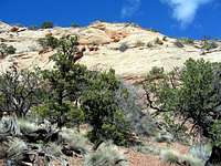
After 1.0 miles, you will reach a slick rock wall near The Neck. Several small streams originate in the wall. They join and flow north/northwest to create a mini canyon called Neck Spring Canyon.
Views of Neck Spring Wall:
 |  |  |
Views of Neck Spring Canyon:
 |  |
The trail then continues over the lower plateau and gives you views of the beautiful slick rock country and the vegetation over it. At a few spots, you will get glimpses of the beginnings of the Taylor Canyon.
Views from the lower plateau:
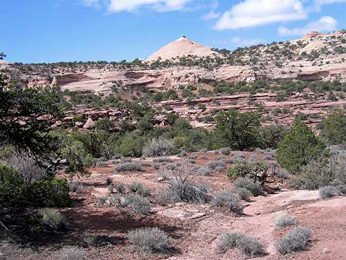
 |  |  |  |

 |  |  |  |
Views of the beginnings of Taylor Canyon from the lower plateau:
 |  |  |
The trail then gradually enters the Cabin Spring Canyon. At 3.05 miles, you will cross the stream.
Views of Cabin Spring Canyon:
 |  |
After crossing the stream, the trail goes 250 vertical feet up a fairly steep slick rock slope to reach the top of the Island in the Sky Mesa.
 |  |  |
The trail then follows the rim of the Cabin Spring Canyon.
 |  |  |  |
After a while, the trail goes away from the rim of the canyon and you will hike on flat terrain over the surface of the Island in the Sky Mesa.
 |  |  |
You will then reach the edge of the Neck Spring Canyon. You can look down to see Neck Spring Canyon below you and Taylor Canyon to the far northwest.
 Neck Spring |  Neck Spring Canyon |  Taylor Canyon |
The trail then reaches the park’s main road again and crosses to the east side of it and then heads north going down in elevation slightly to reach The Neck. At The Neck, you will have to hike along the side of the road. You will have spectacular views of Shafer canyon right below you to the east.
 Shafer Canyon |  Shafer Canyon | 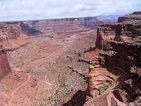 Shafer Canyon |