
|
|
Area/Range |
|---|---|
|
|
33.67980°N / 111.8004°W |
|
|
Hiking, Mixed |
|
|
Spring, Fall, Winter |
|
|
4067 ft / 1240 m |
|
|
Overview
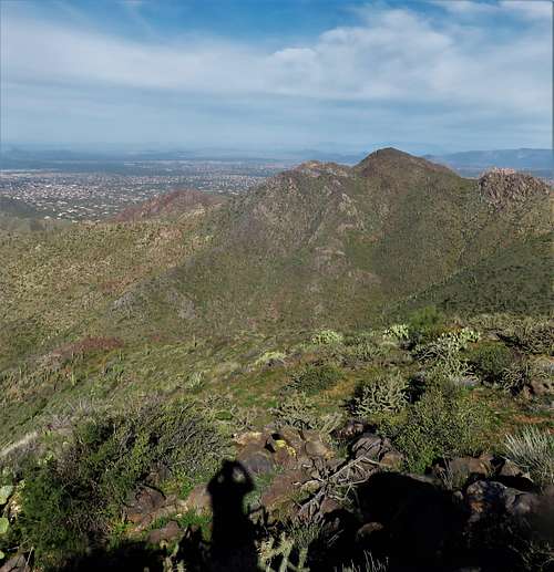
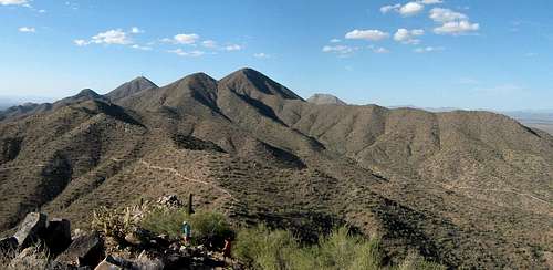
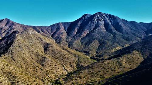
Located in Maricopa County, the McDowell Mountains rise to the east of Scottsdale, Arizona about 20 miles northeast of downtown Phoenix. The range is about 10 miles long and is situated on S/SE trend (from north to south) and is over 5 miles wide at its largest stretch. The north-south boundaries are the Tom’s Thumb Trailhead on the north side and Shea Blvd on the south side.
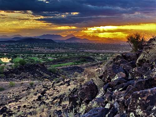
Situated next to a heavily populated and growing area, the McDowell Mountains are very popular and quite treasured. A ballot initiative to create a commercial property near its primary trailhead was defeated in 2018, and there remains considerable support for preserving the land. However, a new housing development on the southeast side of the range has intruded on the range, while creating a new trailhead in the process (Adero Canyon - which opened in November 2020).
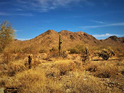
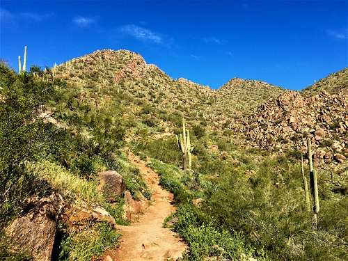
There are several popular trailheads and miles of hiking trails. Most of the prominent summits in the range do not have designated hiking trails; although the range highpoint does have a legitimate use trail.
Off-trail hiking is considered off-limits, although the terrain and cholla cactus makes it difficult to go off-trail as well. Pretty much the entire range is considered part of the McDowell Sonoran Preserve, managed by the City of Scottsdale.
Due to the prevalence of wide trails, hiking in the McDowell Mountains can be done year-round. However, it is recommended that any longer hikes be done between October-April and hikes between May-September be in the morning. There are plenty of rattlesnakes in this range, which is another reason to stay on trails.
Primary Access Points
The McDowell Mountains have several designated public trailheads on all sides.
North Side
The primary trailhead on the north side is the Tom’s Thumb Trailhead. This trailhead has been expanded in recent years and has become very popular. It is reached by taking Arizona State Route 101 to Pima and going north nearly 7 miles and turning right on Happy Valley Road and following it for over 4 miles to Ranch Gate Road on the right. There are trail signs. It is 2 ½ miles from Ranch Gate Road. The address is 23015 N 128th St, Scottsdale, AZ 85255.
From here, there are popular trails leading up to Tom’s Thumb and The Lookout. The range highpoint, East End, is best hiked from this trailhead.
West Side
The two primary west side trailheads are Gateway and Bell Street. Gateway is the much larger of the two. Both of these trailheads are very accessible and near large populated areas. The Gateway Trailhead is a little over 2 miles from the 101, located at 18333 N Thompson Peak Pkwy, Scottsdale, AZ 85255.
While the Gateway Trailhead is located north of Bell Street off the Thompson Peak Parkway, the Bell Street and 104th Street trailhead is located on the north side of Bell Street a quarter mile east of the Thompson Peak Parkway. The address for GPS is Levee Trail, Scottsdale, AZ 85255. It has limited space but isn’t usually as packed as the Gateway Trailhead. From here, the Levee Trail goes east towards the range and connects with trails that emerge from the Gateway Trailhead.
Both of these trailheads lead up to Bell Pass, but do not offer trails to any summits.
South Side
The primary trailheads on the south side are the Lost Dog Trailhead and the Sunrise Peak Trailhead. There are minor trailheads between them on 128th Street and 136th Street, but those lead to the same trail system.
The Lost Dog Trailhead is located at the north end of 124th Street at 12601 N 124th St, Scottsdale, AZ 85259. Getting there is easy. Either go straight north from Shea Blvd or Via Linda on 124th Street. The trails from Lost Dog are generally rolling, with only the Sunrise Peak Trail gaining any significant elevation. The other trails are more popular for trail runners and mountain bikers.
To reach the Sunrise Trailhead continue on Via Linda for a little over a mile past 136th Street. This trailhead provides access to Sunrise Peak 3,063' described in the "Primary Mountains" Section. The main trailhead has limited parking, but there is a lower trailhead with more parking about ¼ mile below the main trailhead. The trailhead address is 12101 N 145th Way, Scottsdale, AZ 85259; and the lower parking lot is passed on the way and is hard to miss.
East Side
There are two trailheads from the east side in or adjacent to the town of Fountain Hills. Both are considered the southeast side, but they are technically located on the east side of the mountain range.
The Dixie Mine Trailhead is the primary trailhead for Thompson Peak and can also be used for Doubletop Mountain. From Loop 101 take the Shea Blvd exit and go east on Shea for 7.5 miles. Turn left onto N Palisades Blvd. and you can take either Sunridge or Golden Eagle Blvd to their ends. I recommend taking Sunridge if coming from Shea and the 101. It is 1 1/2 miles up Palisades from Shea to reach Sunridge, which is on the left. Take Sunridge for 2 miles where it ends. Turn left on Mountain Parkway. The trailhead is half a mile up on the left, before a gate. If coming from the East Valley – Gilbert, Mesa or Eastern Tempe - take Highway 87 to Fountain Hills. It is way shorter than taking the 101. Then take Shea Blvd to the west for about three miles to Palisades and follow directions noted above.
For the Dixie Mine Trailhead, there are no restrictions or fees, but parking is not allowed overnight at the trailhead parking area. The trail may be closed on holidays like Christmas and Thanksgiving. Hikers need to walk through the neighborhood on paved roads for about a half mile to reach the Dixie Mine Trail. At the entrance, hikers are asked to pay a $2 entrance fee. It isn’t clear how that is enforced, but it is recommended payment be made assuming it is used for trail maintenance.
The Adero Canyon Trailhead is a new trailhead that opened in November 2020. Access is from a new paved road built to host new houses being built by Toll Brothers. While this new development encroaches into the mountain range, the new trailhead provides an access point deep into the range with mountain biking trails along with hiking trails. Sunrise Peak can be reached from Adero Canyon,with a similar distance if hiking from Lost Dog; although not as straight-forward as from the Sunrise Peak Trailhead.
There is a way to access Peak 3804 from this trailhead in less than 1 ¾ miles using a main trail up to the ridge and then a use trail along the ridgeline. However, the use trail doesn’t go to the summit.
To reach the Adero Canyon Trailhead, take Shea Blvd get on N. Palisades Blvd as noted above. After 0.8 miles, take a left on Eagle Ridge Dr. and continue to the end of the road. The address is 14800 N Eagle Ridge Dr, Scottsdale, AZ 85268.
Primary Mountains
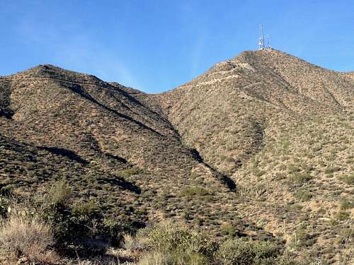
East End – 4,067’
The highest summit in the McDowell Mountains is East End, which has a prominence of 1,357’. East End has a use-trail to the summit and a benchmark. It is not as popular as other peaks in the range because most people pass the trail to East End on their way to Tom’s Thumb and don’t realize there is a trail to the top of East End because it isn't well-marked.
McDowell Peak – 4,034’
The 2nd highest summit in the range is McDowell Peak, with a prominence of 1,004’, the only other 1k prominence peak in the range. McDowell Peak rises over 800’ above Bell Pass. There is no designated trail to the summit, although there are clearly some use paths created by hikers over the years. Because it is technically off-limits, the summit sees few visitors. The summit has a solar panel on top, which doesn’t appear to have been maintained for many years. Reaching the summit itself isn’t particularly difficult, although it is very steep.
Thompson Peak – 3,982’
The third highest summit in the McDowell Mountains in Thompson Peak. It has towers on top, which make it distinct from the other peaks. A trail/road lead to the summit from the Dixie Mine Trail. While the towers are blocked off within a gated area, the highest point that can be reached outside of the gated area is more or less at the highest point on the mountain.
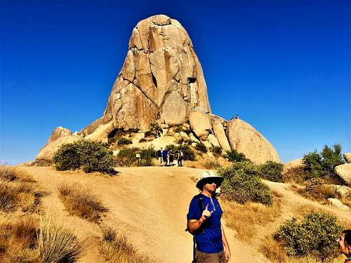
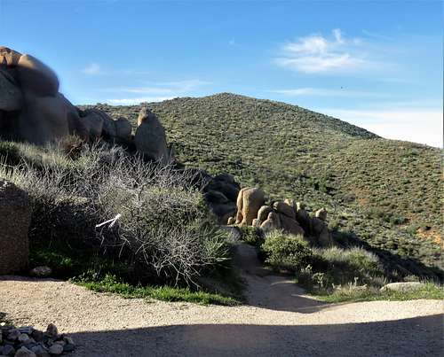
Tom’s Thumb – 3,970’
The fourth highest summit in the McDowell Mountains is probably the most popular to visit. Few people actually climb to the summit. However, Tom’s Thumb is familiar landmark to hikers in the Phoenix Valley. Climbing routes range from 5.2 to 5.11. More details are provided on the individual Tom’s Thumb page.
Lookout Trail Highpoint – 3,949’
The Lookout is a viewpoint south of Tom’s Thumb on a trail heading south of the trail to Tom’s Thumb. About a third of a mile down the trail is a non-descript summit at 3,949’. Since Tom’s Thumb is likely 3,970’, this summit is subordinate to it, and only has a prominence of a little over 200’. However, the summit offers excellent views. It is 80 yards off-trail and about 60’ above the trail, however, given its proximity to the trail, hiking to the top is unlikely to cause any concerns.
Peak 3,804’
Perhaps the most untouched summit in the McDowell Mountains is Peak 3,804’. Because it is technically off-limits, the summit sees few visitors. It is situated about 2/3rds of a mile south of Doubletop Mountain (noted below). For years, it was far from any access point, however, the Adero Canyon Trailhead now offers more direct access. If taking the Western Loop Trail, the summit is about 8/10ths of a mile away from the when the trail reaches the top of the ridge. From there, a use trail continues along the ridge (which sometimes disappears or is hard to follow). The use trail ultimately peters out just below the base of the peak. From there it is less than a quarter mile to the summit, but 450’ of gain. This is very steep and rocky with some cactus that makes it challenging.
Doubletop Mountain 3,702’
Doubletop Mountain is reached via the Dixie Mine Trailhead. It shares a saddle with Thompson Peak and a use trail leads towards the summit but doesn’t go the entire way up. The summit itself is only 250 yards off-trail.
Sunrise Peak 3,063’
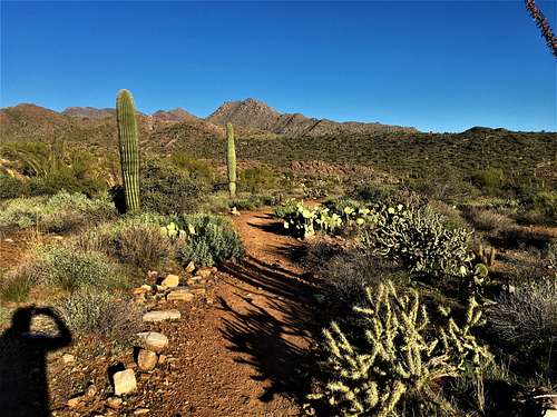
The most popular summit in the McDowell Mountains is Sunrise Peak. Sunrise Peak is primarily hiked from the Sunrise Peak Trailhead with options from the Lost Dog Trailhead and from Adero Canyon. The trail from the Sunrise Peak Trailhead is one of the most scenic in the range, with abundant Saguaro cactus. A hike to the top and back is less than 4 miles round trip.
There are a few other prominent summits at lower elevations in the range, but none of them are on trails, so all of them are technically off-limits.
Red Tape
Hiking in the McDowell Mountains comes with a few rules. Park hours change depending on sunrise and sunset, so hiking in the dark is generally limited due to gates being closed. Dogs are allowed on trails, but must be on a leash.
The biggest issue is off-trail hiking. While some summits require a little bit of off-trail hiking and might not be an issue (Looking Trail Highpoint and Doubletop Mountain are examples), more significant bushwhacking could lead to fines. According to the Scottsdale, Arizona Code of Ordinances, Chapter 21, in the General rules for use, it says that “all preserve users must remain on designated and posted trails to prevent damage to the land and all other areas shall be considered "off limits" for any use.” Per Section 20-132 – General rules of use; prohibited activities, includes a statement reading that “horses, hikers and rock climbers shall stay on designated trails”.
What this means is that hiking Peak 3804 or McDowell Peak or other minor summits like Taliesin Mountain or Peak 2,921 near the Lost Dog Trailhead or Peak 2,790 near the Gateway Trailhead could lead to fines; although enforcement is rare because most people choose to stay on the designated trails given the prevalence of cactus and rattlesnakes during much of the year. McDowell Peak is probably the summit most frequently hiked off-trail. Peak 3804 has a use trail on much of the ridge en route to the base of the summit. However, most use trails don’t meet the definition of “designated trails”; although it is okay to assume that the use trail to the summit of East End does not break the rules.
External Links
https://www.scottsdaleaz.gov/preserve
https://www.scottsdaleaz.gov/Assets/ScottsdaleAZ/Preserve/Preserve+South+Area+Trail+Map.pdf