
|
|
Mountain/Rock |
|---|---|
|
|
33.63720°N / 111.7989°W |
|
|
Maricopa |
|
|
Hiking |
|
|
Spring, Fall, Winter |
|
|
3702 ft / 1128 m |
|
|
Overview
Doubletop Mountain is an unofficial name for Peak 3702, which is located in the McDowell Mountains to the east of Scottsdale, Arizona. It has a prominence of 372’. Located nearby large swaths of population, Doubletop Mountain has very little respect. Hundreds of thousands of people see its twin summits every day, yet few ever venture up to the top. Nearby Thompson Peak 3,982’ is far more popular, and the two can easily be combined on the same trip.
The Dixie Mine Trail leads to the turnoff to the summit in just over 4 miles from the Dixie Mine Trailhead off Mountain Parkway in Fountain Hills. From there, a light use trail, and some light scrambling, lead to the summit. Doubletop Mountain is best hiked outside of summer months. The fact that it goes off-trail for the last half mile means that rattlesnakes may be present when the temperature is 70-80 degrees, or slightly hotter. Late October through late March are recommended times; preferably in the morning if in October, November, February, or March.
Given the summit is 250 yards off-trail, the summit can be considered technically off-limits per the rules of the McDowell Sonoran Preserve. Keep that in mind while hiking and use your best judgement.
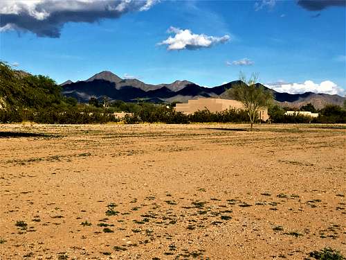 McDowell Mountain Range - Doubletop Mountain in the center
Getting There
Directions are the same as to Thompson Peak. From Loop 101 take the Shea exit and go east on Shea for 7.5 miles. Turn left onto N Palisades Blvd. and you can take either Sunridge or Golden Eagle Blvd to their ends. I recommend taking Sunridge if coming from Shea and the 101. It is 1 1/2 miles up Palisades from Shea to reach Sunridge, which is on the left. Take Sunridge for 2 miles where it ends. Turn left on Mountain Parkway. The trailhead is half a mile up on the left, before a gate. If coming from the East Valley – Gilbert, Mesa or Eastern Tempe - take Highway 87 to Fountain Hills. It is way shorter than taking the 101. Then take Shea Blvd to the west for about three miles to Palisades and follow directions noted above.
Route
From the parking lot walk through the private community gate and follow the sidewalk about half a mile to the actual trailhead. Shortly down the trail there is a $2 entrance fee. You fill it out and keep the receipt on your person. It isn’t often checked, but the money goes to keep the trail nice, so it is worth the expense regardless. Follow the Dixie Mine trail through a classic Sonoran desert landscape and crossing a couple of washes for about 2 miles until you reach jeep road near the Dixie Mine. Turn left here onto the jeep road. After a mile up the jeep road, it starts to get really steep as it heads up to the saddle between Doubletop Mountain and Thompson Peak. Once at the saddle, you can see the two summits to the south. There is a trail that kind of fades after about 100 yards or so. However, there is a faint path going all the way to the base of the first summit. The trail seems to continue up the steep part, but it quickly fades. The trick here is to avoid the rocks beneath the first summit and head to the right side of the rocks. You will find there is a decent route to be taken to get up to the first summit. Once on the first summit, descend down to a saddle, and the true summit is easily reached. Overall, there is some light scrambling required, but nothing too uncomfortable for experienced hikers.
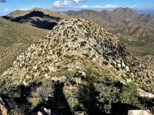 Hiking the final stretch to Doubletop Mountain in the McDowell Mountain Range
Red Tape
You are asked to pay a $2 entrance fee just past the actual trailhead (not at the trailhead parking) and you cannot park overnight at the trailhead parking area. The trail may be closed on holidays like Christmas and Thanksgiving. It isn’t clear how that is enforced, similar to the $2 fee. There is the option to take the jeep road, but that is for 4WD, and it isn’t recommended for hikers unless you want to take a 4WD.
It isn't clear whether the use path en route to the summit is considered a designated trail or not. However, the summit itself is off-trail. According to the Scottsdale, Arizona Code of Ordinances, Chapter 21, in the General rules for use, it says that “all preserve users must remain on designated and posted trails to prevent damage to the land and all other areas shall be considered "off limits" for any use.” Per Section 20-132 – General rules of use; prohibited activities, includes a statement reading that “horses, hikers and rock climbers shall stay on designated trails”. What this means for hiking Doubletop Mountain is that hiking to the summit violates these general rules for use because it isn’t on a designated trail. If caught, you may be subject to a fine. However, these rules are in place primarily to prevent bushwhacking through large swaths of untouched areas of the Preserve, therefore hiking to the summit would be less of a concern than trail-cutting in other areas of the Preserve. But, it still violates the General rules for use.