
-
 8013 Hits
-
 91.14% Score
-
 34 Votes
|
|
Mountain/Rock |
|---|---|
|
|
49.20157°N / 20.04938°E |
|
|
Hiking, Scrambling |
|
|
Spring, Summer, Fall, Winter |
|
|
7326 ft / 2233 m |
|
|
Intro
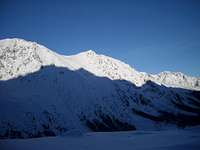
Miedziane 2233 Massive peak in the lateral ridge separating Morskie Oko lake cirque and Five Polish Lakes valley Miedziane above Marchwiczna pass
No marked trails leading to the main summit just crossing and traversing the mountain which area is preserved as natural reservation in Polish Tatra National Park. The most special one of all Miedziane peak attractions is the view from its summit considered as one of the most magnificent summit panoramas in Tatras. Miedziane name became famous about that due to “Panorama Tatr”.
It was a huge painting (115 m long and 16 m wide, 1840 square meters) created by a group of painters in years 1894-95
in Tatras and then exhibited in Munich in 1896 and then in Warsaw. The professional description of the masterpiece was made by the greatest Polish Tatra poet and novelist Kazimierz Tetmajer. The name of the peak comes most probably from mining works that were undertaken on its slopes in 18th century.
The copper (Pol: “Miedz”) used to be extracted there. No documented first ascent. Miedziane summit was climbed by local mountaineers and sheperds since at least 18th century
as the area was one of the highest sheperd locations in Tatras. First winter ascent: 1911 – Henryk Bednarski and L.Michalski
Miedziane (2233)
Miedziane peak(2233) rises above Rybiego Potoku valley in the East and Five Polish Lakes valley in the West.The peak is located in a lateral ridge that branches off north from the main Tatra ridge in Szpiglasowy Wierch peak(2176). Szpiglasowa Przelecz pass(2110) separates both peaks. North to the main summit of Miedziane, the ridge descends to wide Marchwiczna Przelecz pass(2055) after which rises the 2nd highest peak of the ridge – Opalony Wierch(2115) which northern slopes fall through Swistowka Roztocka rocky cirque and Swistowa Czuba vertical cliffs down to Roztoki valley. The ridge turns then east and going along Opalone area above Roztoki valley ends in Roztocka Czuba(1426) above Bialki valley near Wodogrzmoty waterfalls.
 Miedziane above Five Polish Lakes valley
 Miedziane(2233) Miedziane(2233) |
 Czarny Staw lake Czarny Staw lake |
 In winter In winter |
Getting There
 Towards Roztoki valley
 Wielki Staw Polski lake
Routes Overview
There are no marked trails leading to Miedziane summit, but there are two, very popular ones crossing the massif: The path traversing the ridge in its northern part below Opalony Wierch peak via Swistowka Roztocka is the shortestand easiest connection between Five Polish Lakes valley and Morskie Oko lake. Quite crowdy on sunny days during summer season, the trail is being closed for years fot the whole winter, as it is usually seriously endangered by avalanches falling from Opalony Wierch slopes towards nearby abyss of Roztoki valley(several fatal accidents took place there). Five Polish Lakes valley, mountain chalet on Przedni Staw lake(1669) – Swistowka Roztocka – Morskie Oko lake, mountain chalet(1405). Blue marks, 4 km, 1.45 h
 Szpiglasowa pass
old sheperd shelter(1740). Yellow marks, 6.2 km, 3.15 h The easiest way to reach Miedziane summit is just an easy walk up the ridge from Szpiglasowa pass, it should take no more than half an hour, but one must be aware that it’s forbidden according to National Park regulations and once taking an attempt you may be fined by national park guards. The second summit route leads more or less via whole ridge spreading north-east from Miedziane from the traverse in Swistowka Roztocka on the blue marked trail passing Opalony Wierch summit(2115) and further via deep and wide Marchwiczna Przelecz pass(2055) conitnuing by the edge of the ridge becoming sharp and exposed(UIAA I) in some places,
to the main summit. Traversing below the ridge on its eastern side is risky(cliffy terrain) and disorientating and therefore shouldn’t be undertaken. In winter serious avalanche risk in the area.
Miedziane peak area - Map
 Tatry Wysokie (High Tatra) map, in scale 1:25 000, description in 6 languages, ISBN 83-87873-26-8, available in all shops
and book stores in Zakopane . Here you can check the net version Tatra Maps (English version)
When To Climb
Best time for climbing/hiking : August – October. June/July : frequent t-storms ,heavy rainfall periods and foggy weather. Planning to visit Tatra Mountains in winter, don't forget to check current TOPR avalanche forecast first. Severe and extremely changeable high mountain climate …be always prepared for sudden weather breakdowns ! Rescue Phone Number : +48 601 100 300 or 18 300 TOPR - Tatra Mountain Rescue(Poland) Horska Sluzba - Tatra Mountain Rescue(Slovakia)Red Tape
 Carlina acaulis
to "open borders" Schengen Area, however one must remember that National Park regulations prohibiting crossing the border beside marked trails in the whole area
remain in force.
Camping
Lots of accomodation possibilities of different standard and price in Zakopane, Bukowina Tatrzanska, Slovak Zdiar and the whole area. The nearest mountain chalets in the area are Morskie Oko chalet in Rybiego Potoku valley, Stara Roztoka chalet in forests of lower part of Bielovodska valley and Poland's highest located mountain chalet on Przedni Staw lake in Five Polish Lakes valley("Dolina Pieciu Stawow Polskich"(Pol)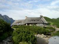 5 Polish Lakes chalet