

-
 41027 Hits
-
 87.31% Score
-
 24 Votes
|
|
Area/Range |
|---|---|
|
|
43.53986°N / 5.64435°E |
|
|
Hiking, Trad Climbing, Sport Climbing, Toprope, Bouldering, Scrambling, Via Ferrata |
|
|
Spring, Summer, Fall, Winter |
|
|
3100 ft / 945 m |
|
|
Overview
Montagne Sainte-Victoire
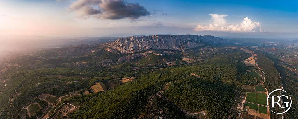
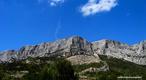
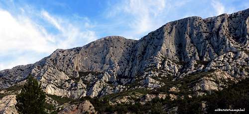
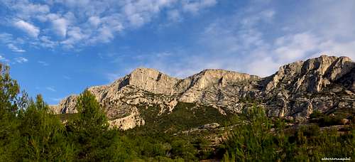
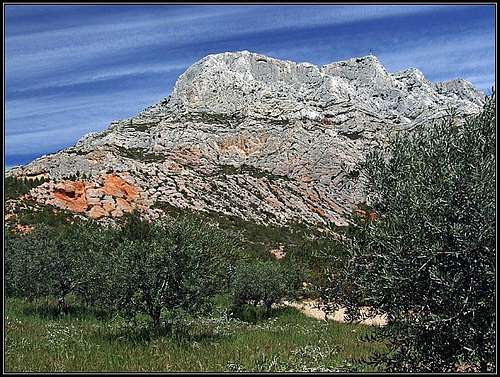
The Montagne Sainte-Victoire is an extended limestone massif situated in the Provence-Alpes-Côte d'Azur region (PACA), Southern France, between the departments of Bouches-du-Rhône and Var. It is stretching in the West-East direction and reachs on its highest point, the Baou des Vespres, the altitude of 1011 m. The massif is located to the East of the town of Aix-en-Provence and has an international reputation in reason of its beauty and also because of several paintings by Paul Cézanne. It's a veritable symbol of Provence, like the Sainte-Baume and Mount Ventoux, the major landmarks of the Aix-en-Provence region. On the South side the Montagne Sainte-Victoire appears as a huge rocky bastion 18 km long and 5 km wide with a 7 km long summit plateau.

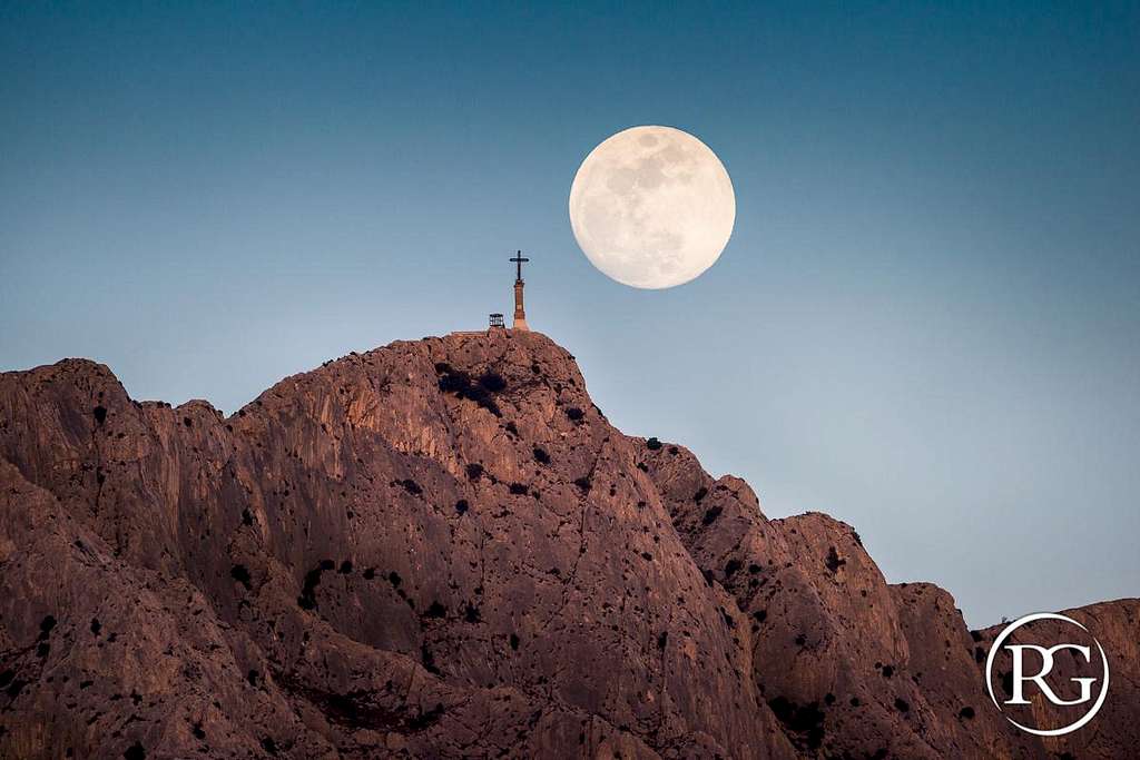
This charmer massif, rising from the Mediterranean plains with its immaculate rocks, exerts an extraordinary appeal even if observed from a distance. The Montagne Sainte-Victoire has different summits lined up along its extended summit ridge; starting from the West we observe the Croix de Provence 946 m, the Signal, the Baou des Vespres 1011 m and the Pic des Mouches 1010 m, where it's located a beautiful "table d'orientation". The culminating summit, which is only one meter higher than the Pic des Mouches, is the Baou des Vespres. Amongst these summits the most famous is the Croix de Provence 946 m with its 19 metres high cross; although not placed on the highest point of the mountain, it stands out from the ridge far more than the Baou des Vespres and Pic des Mouches.
Baou des Vespres and Paroi du Grand Couloir general overview (S side)
The massif is mainly built by beautiful white and grey limestones, while in the lower part other rock structures are also present, like the conglomerates. This morphology gives to the range a palette of vivid colours, besides white also all variants of red. The two sides of the massif are very different: to the North a steppe which at the bottom land gives way to the forest of oaks and pines of Aleppo, sloping towards the Vallon de Delubre and the village of Vauvenargues, to the South a seemingly insurmountable sunny wall, mostly a sheer, almost vertical drop, while the Northern side is far less steep. On the area various karst phaenomena can be seen. One such example are rock windows or in some cases deep caves, such as for example Garagaï gouffre. West of the mountain is the well known town of Aix en Provence. To the NE of the mountain two artificial lakes can be seen. The dam of the lower one is called Barrage Zola, after its architect Francesco Zola, the father of the well known writer Emile Zola. This dam and the higher Barrage de Bimont were constructed already in the middle of 19th century, ensuring manageable water resources for the whole area.
Paroi de la Vierge and Piliers du Suberoque (S side)
Montagne Sainte-Victoire overview
The mountain has a long and rich history. Below it, it took place fierce battles between the ancient Romans and the neighbouring tribes, on the southern side remains of an ancient town can be seen (also Aix flourished under the Ancient Romans). Later the Western summit - Croix de Provence - became widely known for pilgrimage. In the 13th century, a chapel dedicated to "Sainte Venture", as the mountain was once also called, was built just below the summit of Croix de Provence on the Brèche des Moines (Monks' Notch) 888 m. Nowaday we can see the building of Prieuré (Priory) which stands there since the 17th century. It is called Notre-Dame-de-Ste-Victoire and on top of the nearby summit (the Croix de Provence) a 19 m high cross was erected. In 1989 a huge fire devastated 5000 hectars of forests and the mountain has still been recovering from that. It is said that in summer the access is restricted, but otherwise hikes on top are very popular. It is estimated that 700 000 people climb it each year. Far the most popular is the summit of Croix de Provence. The area of the Montagne Sainte Victoire is also proclaimed to be one of Grand Sites de France. On the Southern terrace of Sainte Victoire there are a few villages, and some one are also in the valley North of it. There are several trailheads for summiting the mountain. On the Southern side, after the big fire, it was built the Maison de Sainte-Victoire, nowaday hosting the agency for protection and the parc headquarters, but also a tourist info center. Another tourist info center is situated on the other side, on the North, in the nice village of Vauvenargues, which is well known because of the famous Pablo Picasso, who bought a small castle there and he is burried nearby. On the Western side every stone and tree reminds of Paul Cézanne, who lived below the mountain and painted there. The Montagne Sainte-Victoire is often referred simply as the "Cézanne's mountain". Today, many of his paintings are in Philadelphia Museum of Art. See here an example, posted on Wikipedia.

|

|

|
Getting There
By plane - Sainte Victoire massif is situated 35 km from Marseille and 180 km from Nice, so the best option is to fly to Marseille or Nice and rent a car.
By car - The nearest town is Aix-en-Provence. The A8 autoroute runs South of Sainte Victoire and Aix-en-Provence. If coming from the Nice direction, exit the A8 onto the RN 7 in the direction of Aix. From Aix, take the "Route de Cézanne", road D17, which traverses under the South side of the massif from Les Tholonet at the Western end to Puyloubier at the Eastern one, passing across Beaurecueil and St. Antonin. There are several parking lots along this road. The whole Montagne Sainte Victoire can be encircled by a good, panoramic local road, which brings us to all the trailheads. Starting from Beaurecueil we meet several parking lots from which we can take the different routes leading to the summit or to the various climbing sectors.

|

|
Red Tape
No fees, no permits required and no restriction from October to May, while the access to Sainte-Victoire is strictly regulated from June 1st to September 30th to avoid any risk of fire. Indeed, during the summer months, due to the heat, the climate-dryness and the intense sunshine, the fire hazard is very high. The restriction depends on the weather condition.
You must call the day before 18:00 on 08 11 20 13 13 to know the conditions of access or visit the site Feuxdeforet.fr. There are 3 levels of forest fire danger: the Orange level (you can hike), the Red level (you can hike between 6am and 11am in the morning and the Black level (the hike is forbidden under penalty of fine). Wild camping is of course also forbidden.
Main interests: hiking, scrambling, climbing
Hiking and scrambling
The main interests in the area are one day and half a day walks, M-biking and particularly trad and sport climbing, plus scrambling and easy scrambling on all the various summits lined up on the summit ridge. These summits can be all crossed walking on an easy trail, the GR9. Croix de Provence 945 m, with its 19 metres high cross, although not placed at the highest point of the mountain, is a popular hiking destination, like several other places in the massif, which can be explored along its countless paths, also to look at the fascinating sites of religious heritage, as the Saint-Ser Hermitage, a tiny chapel surrounded by wonderful scenery, or the Sainte-Victoire Priory.
Start of the route to Croix de Provence via Refuge Cézanne
Climbing A perfect area for walking, but even more to climb. Montagne de Sainte-Victoire is really a wonderful world of stone, therefore it's a great drawn for climbers, due to the amazing limestone, the plenty of routes on all the summits, the beauty of the landscape. The rock climbing destination at Sainte-Victoire is the South face, which counts around 1000 routes, 29 or more sectors and 7 separate parking lots, an astounding space to climb up a surprisingly sticky limestone. As it's the custom in France, here different ways of climb and equipment coexist, and thus we can find routes with different styles and committment, ranging from the modern well equipped single pitches to the partially equipped routes and the high walls, plenty of long and adventurous routes, which nowadays often remain parsimoniously equipped.
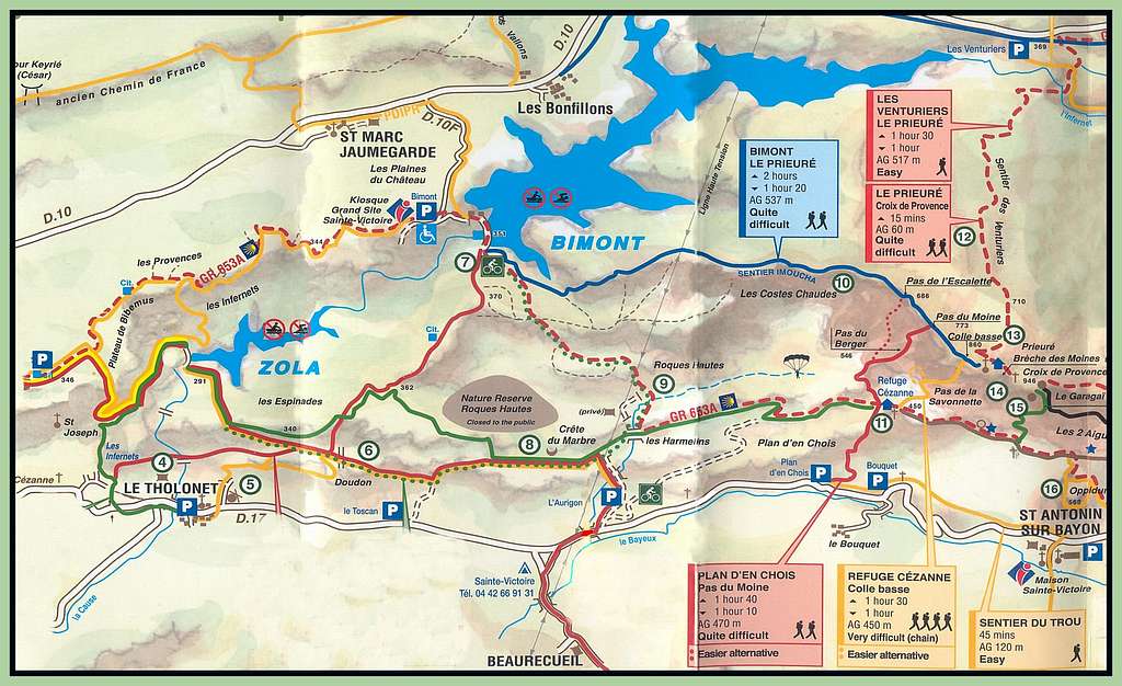
Sainte-Victoire general plan and Parking lots
Whether you want to walk, scramble or rather climb, you need to understand the arrangement of the various parking lots located along the Southern side of the area, crucial as all the itineraries start from there. Starting from Beaurecueil from West to East we meet:
P1 - Parking Plan d'En Choise and the adjacent Parking Bouquet, also named Parking Cézanne
P2 - Parking des Deux Aiguilles
P3 - Parking de la Carrière
P4 - Parking du Collet de Saint-Pierre
P5 - Parking de la Torque also called Parking du Saut du Loup
P6 - Parking de Saint-Ser
On the Northern side from West to East we meet:
- Parking Bimont
- Parking Les Venturiers
- Parking Yvon Gouirand
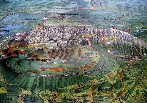
Montagne Sainte-Victoire maps
Western Sainte-Victoire map
Overview of the Normal Routes to the summits
The 4 main summits of the Montagne de Sainte-Victoire are lined up on the summit ridge and starting from West towards Est they are: the Croix de Provence 946 m, the Signal , the Baou des Vespres 1011 m and Pic des Mouches 1010 m. These summits are connected by an easy trail, the GR9 (red-white marks), starting from Les Venturiers Parking lot (site Les Cabassols). By far the majority of the Normal routes rises from the South side, but there are also some itineraries rising along the North side.

|

|
Croix de Provence 946 m
- Red Trail across Pas du Moine or Pas de l'Escalette - Quite difficult (the right branch), Easy (the left branch) - RED MARKS
The shortest ascent on Croix de Provence is from the SW. The well worn path (red marks) starts from the P1 - Parking Plan d'En Choise or from the adjacent Parking Bouquet and reachs the Refuge Cézanne. After the shelter the trail forks (2 variants) - the easier one heads to left and goes around to the Pass de l'Escalette, the steeper one is some 15 minutes shorter and requires some easy climbing (1 or 2 places of UIAA I). On the summit crest both the variants join the Blue Trail (Sentier Imoucha) coming from Bimont, then the GR9 coming from Vauvenargues (Northern side). In the upper part the trail reachs the Sainte-Victoire Priory, then in a few minutes the summit cross. 1 h 45 min.
- Yellow Trail and Baou des Vespres and Pic des Mouches crossing
This ascent to Croix de Provence is situated on the border of climbing (II grade UIAA in rock). Once getting the Croix de Provence the route is an easy crossing to Baou des Vespres and the farthest Pic des Mouches.
- GR9 Sentier des Venturiers (Northern ascent from Vauvenargues) - Easy, marked path - RED-WHITE MARKS
This route starts from Les Venturiers Parking lot (site Les Cabassols), located East to the village of Vauvenargues and reachs directly the Sainte-Victoire Priory along the GR9 path (red-white marks), then climbs up to the summit cross. 2h. Coming from Aix-en-Provence approximately 1 km before Vauvenargues park the car on a parking lot where there are the signposts towards the Montagne Sainte-Victoire. From the carpark to the South rising along the Northern slope on the path of the Venturiers, well marked, getting the Croix de Provence. From there continue Eastwards along the GR9 to cover part of the ridges, getting the Col de Suberoque and then descend again on the Northern slope on another signposted path, the Path of Plaideurs, as far as Vauvenargues. Join the car park along the river La Cause.
- Blue Trail or Sentier Imoucha - Easy, marked path
This route starts from the Bimont Dam and reach the Priory from the West via the Crete des Costes Chaudes. During this easy ascent you will almost always have a constant view of the Croix de Provence. On Pas de l'Escalette (big cairn) the Sentier Imoucha joins the the easy branch of the Red Trail coming from the Refuge Cézanne, you must continue to go straight, following the blue marks. Successively another big cairn on Pas du Moine indicates the junction with the Red Trail (the harder branch). Further you will reach the junction with the GR9 (Red and white marks) coming from Vauvenargues and soon the Priory. The Croix de Provence is not far away...

|

|
Le Signal 969 m
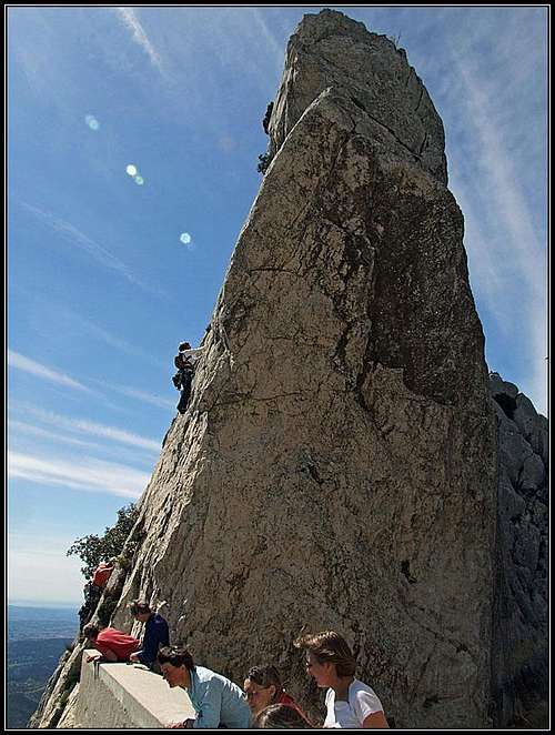
- Black Trail from Parking Les Deux Aiguilles - Very Difficult
This route starts from Les Deux Aiguilles Parking lot, 500 meters east of the Maison Sainte-Victoire, in the municipality of Saint Antonin sur Bayon. It's a marked route, but reserved to confirmed scramblers, in fact it's involving several climbing spots. A long and beautiful East to West crossing. The first difficulty is the "Pas de l'Eléphant", then the "Pas de l'Aiglon". In the upper part the Black Trail joins the Green Trail Forcioli, described below.
- Green Trail or Forcioli - Very Difficult
You can either start from the parking P1 Parking Plan d'En Choise or the parking of the Maison de Sainte-Victoire or the adjacent P2 Parking Les Deux Aiguilles after Saint Antonin. It is a technical route, the more difficult South side and perhaps the more direct, starting with the "Tortoise" exposed passage, continuing through passages a little "airy" and ending at the Cave of Swallows or Tunnel Garagaï.
Tunnel du Garagai
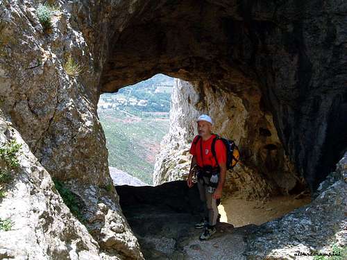
Baou des Vespres 1011 m
Although only for 1 meter, the Baou des Vespres 1011 m surpasses the Pic des Mouches, located to the East, and it's therefore the highest summit in the Montagne de Sainte-Victoirearea. The top of the Baou des Vespres can be reached taking the GR9 and following the long summit ridge starting from the Croix de Provence or from the nearest Pic des Mouches or climbing a more direct route starting from P5 - Parking de la Torque.
- Le Grand Couloir trail
Pic des Mouches 1010 m
- Red Trail from Parking de Saint-Ser -
An itinerary with a few rocky passages starting from the Parking de Saint-Ser, which allows to visit the chapel St-Ser, restored in 2001.
- Blue Trail from Parking de Saint-Ser -
A wild route, which goes up the small and steep Tine valley. The only real technical passage is a bit steep rocky corridor.
Climbing sectors
Brèche des Moines
As told in the previous chapter, the rock climbing destination at Sainte Victoire is the South face, which counts around 1000 routes, 29 or more sectors and 6 separate parking lots. The climbs are of all difficulties and of heigths up to 400 meters. We can find routes with different styles and committment, ranging from the modern well equipped single pitches to the partially equipped routes and the high walls, plenty of long and adventurous routes, which nowadays often remain parsimoniously equipped. To simplify the access to the various cliffs and walls, sometimes not easy given the extension of the massif, the different climbing sectors have been divided into 6 major groups depending on the departure parking lot. The 6 parking lots are arranged in order of increasing numbers from West to East along the road that skirts the massif to the South and leads to Puyloubiere:
- P1 Parking Cézanne - The main sectors are: Baou Cezanne, Falaise du Prieure, Dalles Grises, Grotte de l'Os et Perroquet Vert, Falaise de la Croix
- P2 Parking des Deux Aiguilles - The main sectors are: Deux Aguilles, Le Grand Parcours, la Paroi du Signal, Aiguille des Gatz'Arts
- P3 Parking de la Carrière - Surplomb de la Carriere, Roque Vaoutarde
- P4 Parking du Collet de Saint-Pierre - Paroi de la Vierge, Piliers de Subèroque, Baou de Saint Saturnin
- P5 Parking du Saut du Loup - Baou des Vespres, Tour Rouge, Grand Couloir, Genty
- P6 Parking de Saint-Ser - Ermitage, Vallèe de la Tine
A short history of climbs
The first true climbs were done on Montagne Sainte Victoire in the 40-ies of the previous century. In the next 20 years all most important climbing routes were done. Two of these became a legend: Les 2 Aiguilles and Saint Ser. In 70-ies the era of technical climbing began and in 80-ies almost all the rest among nowadays routes were climbed. At that time this climbing area was one of the most important ones in France. After the big fire some restrictions were introduced and the routes needed to be equipped again. Also in Montagne Sainte Victoire cleaning of routes started, when much of the equipment was removed out of the walls.
Nature and climate
Montagne Saint Victoire has been recognised as a Grand Site de France since 2004 and it's a French jewel of natural heritage which must be preserved. Covering 35,000 hectares near Aix-en-Provence and Marseille, the Concors and Sainte-Victoire massifs form the largest single wooded area in the department of Bouches du Rhône.
, walls of Montagne Sainte Victoire")
Climate is typically Mediterranean, characterized by a great dryness with high sunshine. The area is sometimes subject to the strong wind from the northwest, the "mistral". Although the massif is next to an area of intense urbanization and is very frequented (we talk about a million visitors a year), it's a coffer of biodiversity.

|

|
At least the 20% of all the French flora, 900 species, was found in a relatively limited space on this massif, that provides a plurality of environments and habitats, with vegetation ranging from that one typical of steppes and cliffs, to that one of wetlands. The fauna is rich and diverse, especially on the Northern side. Here live the wild boar and the fox. There were observed 130 species of squirrels and several species of raptors, these latter especially on the S side.

|
")
|

|

|
")
|

|
Other info here: Grande Site Sainte Victoire.
Summit Views
Being so far to the south, Montagne Sainte Victoire, and its Western summit Croix de Provence as well, offer a breathtaking panorama. In a clear day towards the south the views fly to the Mediterannean sea and towards the NE to Alps Maritimes. All the hilly Provence is around us and on the west the big town Aix en Provence can be clearly seen. We can see the mountain massifs of Ste-Baume and Étoile on the south, more to the right the Vitrolles chain, the Crau plane and the valley of Durance river, Luberon and in the Sainte Victoire range itself, to the east we see a bit higher Pic des Mouches. The nearby scenery is also very picturesque: vertical limestone crags, sharp ridges and up to the top growing mediterannean flora.

|

|

|
Huts and Camping
There are different places to stay close to Montagne Sainte Victoire. We can find equipped campsites in Puyloubier, Beaurecueuil,Rousset and Peynier:
- Camping Sainte-Victoire (Beaurecueil)
- Camping Le Devançon (Peynier)
- Camping Le Cézanne (Puyloubier)
- Camping du Coteau de la Marine (Rousset)
Alternatively Gites are available in St. Antonin and Puyloubier and Hotels in Puyloubier, Rousset, Peynier, Fuveau.
When to climb and hike
In addition to being strictly reagulated, climbing and hiking in high summer are not advisable in reason of the excessive heat. You can climb and walk also during the winter, but sometimes the weather can be cold and windy.
Meteo
Meteoblue Montagne Saint Victoire
Climbing guidebook
 |
 |
"Escalade en pays d'Aix" Daniel Gorgeon and Philippe Légier - Ed. Nota Bene, 320 pages, last edition: 2015
"Escalade Sainte-Victoire" - Daniel Gorgeon and Philippe Légier - Ed. Nota Bene
History of the page
In the beginning the page was named 'Croix de Provence', but as later Alberto created the page of Baou des Vespres and asked me to rename it, now it is the area page of Montagne Sainte Victoire. But most of information here is only about Croix de Provence.