
|
|
Mountain/Rock |
|---|---|
|
|
45.88729°N / 10.92693°E |
|
|
Trentino |
|
|
Hiking, Trad Climbing |
|
|
Spring, Summer, Fall, Winter |
|
|
4199 ft / 1280 m |
|
|
Overview
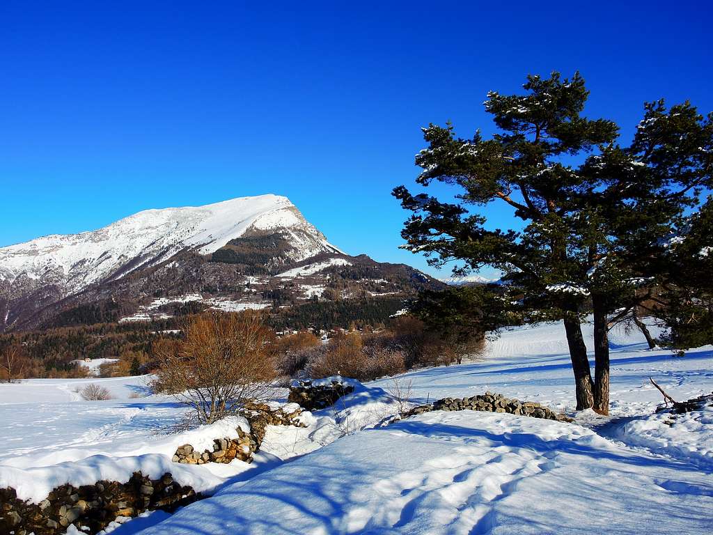
Monte Creino 1280 m
Monte Creino belongs to the Prealpi Trentine and is located between Garda Lake to the West and Val di Gresta to the East. It is one of the minor mountains in the Garda area, little known but deserving to be climbed more than once through different itineraries. In fact Monte Creino has many aspects. Its wide summit plateau falls to the South-West side with a vertical rock face, on the contrary towards the West it slopes down with wooded slopes through which it is possible to reach easily the summit.
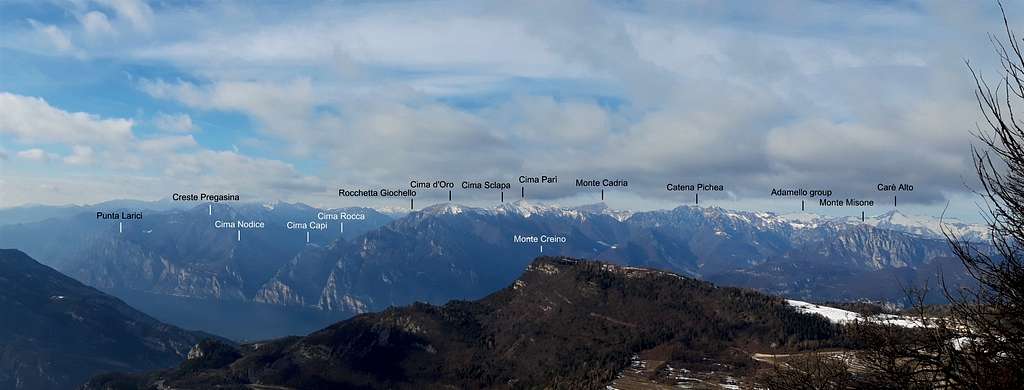
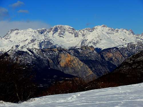
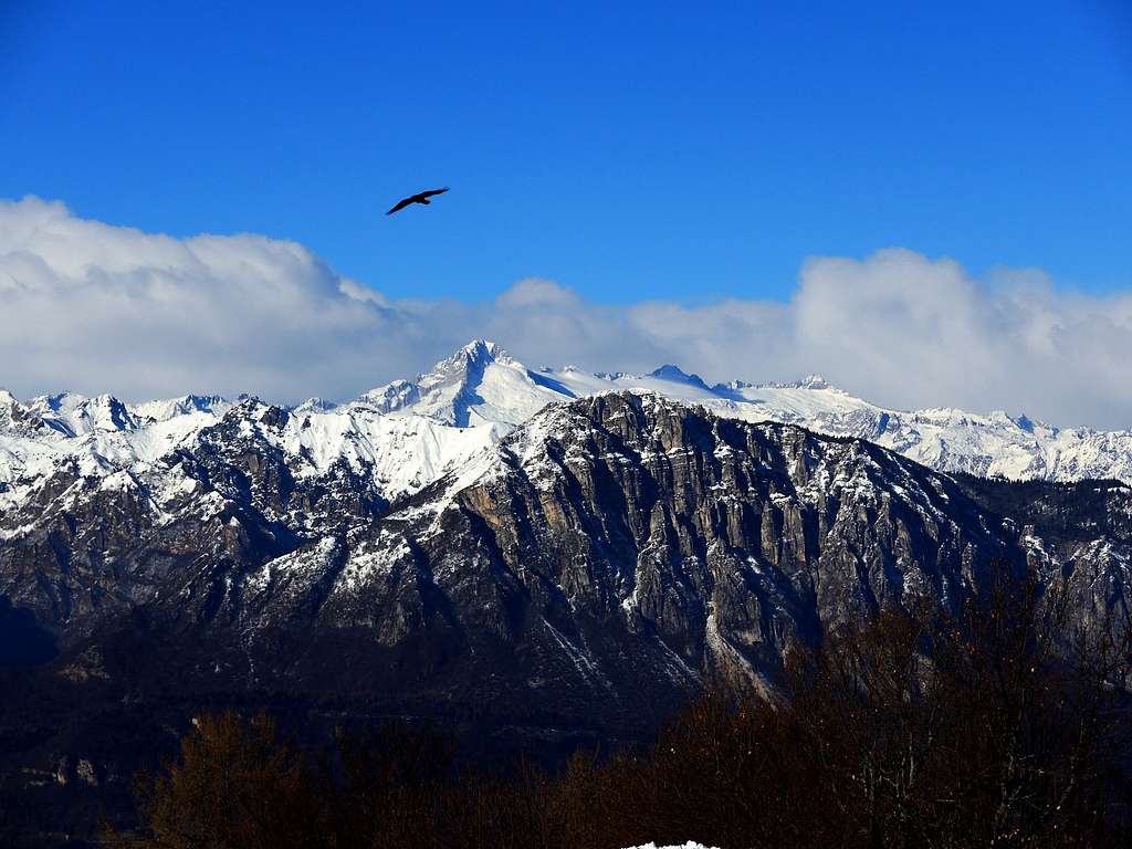
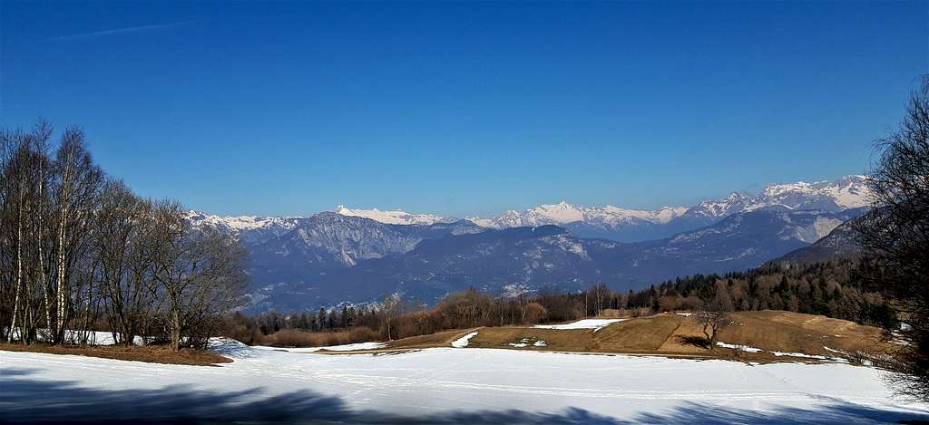
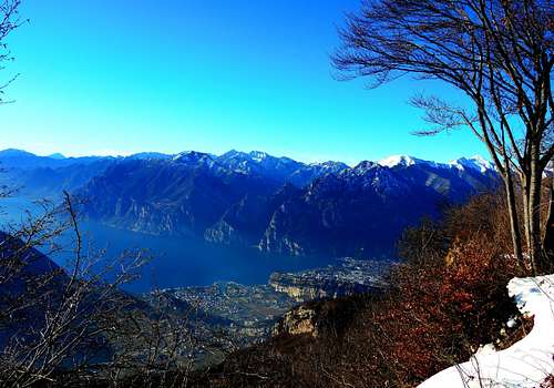
From the rocky edge of the vast summit plateau it opens a wide panorama that ranges from the underlying Garda Lake with the mountains that surround the body of water to the Alpi di Ledro, to the groups of Presanella and Adamello, to the Sarca Valley and Brenta Dolomites.
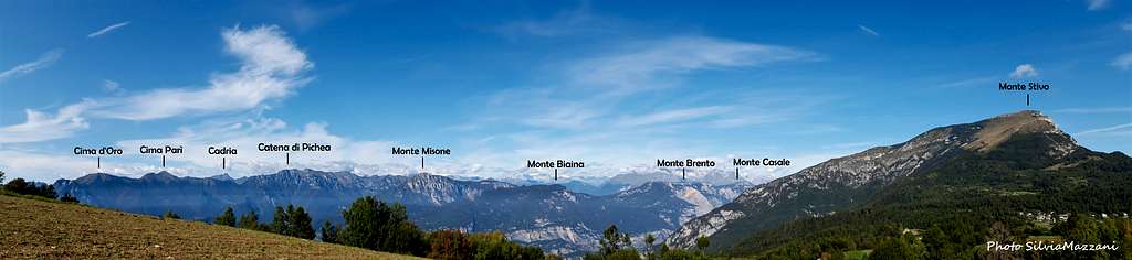
To the opposite side (towards East) to the horizon we can distinguish the Pasubio. Very close to Monte Creino we see both Monte Stivo and Monte Biaena and to the North-West the immense rocky walls of Monte Brento, Monte Casale, Cima alle Coste that border the Valle del Sarca on the orographic right.
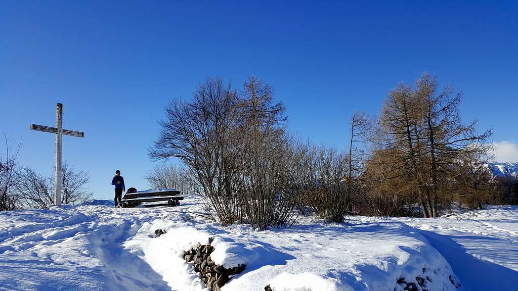
On the summit there are a cross and an observatory of the Austro-Hungarian positions during the First World War. The cross is actually located lower and west of the culminating point of the mountain. On the eastern side, starting from the observatory we find a long series of beautiful trenches built with stones dating back to the First World War and very well preserved from which the Austro-Hungarian soldiers could control the Italian positions on Monte Altissimo.
|
|
There are three possible itineraries to reach the summit and enjoy this incredible panorama: one very short and with a moderate difference in level starting from Santa Barbara, one intermediate starting near the village of Pannone and a third much more demanding in reason of the greater difference in level starting from Nago. In the next chapter it will be described the intermediate route.
Getting There
Road access
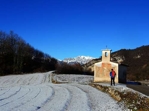
Coming from A22 Auto Brennero exit Rovereto Sud. From Rovereto there are two possible roads to reach Pannone and Passo Santa Barbara, both in Val di Gresta, the starting points of two of the three possible routes: via Val di Gresta or via Val Lagarina.
- Val di Gresta approach: follow the signposts to Riva del Garda, getting to Loppio, between Mori and Nago. At the Loppio roundabout turn to right and follow the signposts to Val di Gresta, along the road SP88, towards the villages of Ronzo – Chienis, which you will reach after about 12 kilometers, then Pannone.
- Val Lagarina approach: follow the signposts to Villa Lagarina and Passo di Cei, then to Passo Bordala and Val di Gresta
The village of Nago, the starting point of the third itinerary, the longest, is reached from Rovereto following the signposts to Riva del Garda, getting to Loppio and Nago.
Monte Creino from Pannone
Difficulty: E
Vertical gain: 400 m
Road access
Once you reach the village of Pannone in Val di Gresta, briefly cross the village in the direction of Passo Bordala and continue to follow the road up to a hairpin bend from which a road on the left comes off at the signpost "Agriturismo Narango". Before arriving at the Agriturismo you will find a junction to the right with the signpost "Trincee Monte Creino". Parking lot.
Route description
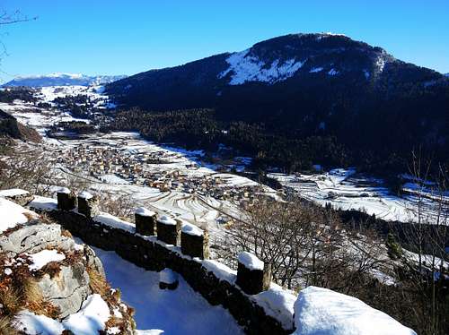
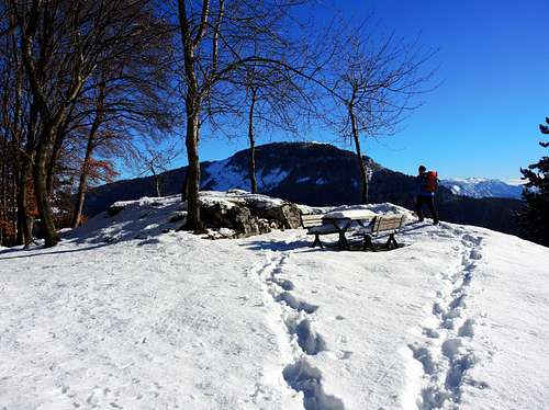
Take the forest road on the right and follow it up to an obvious fork in the woods with signposts. Take the path on the right, gradually climbing into the dense forest up to a small grassy clearing. Frome here take a track on the left that climbs more steeply up to a shelf equipped with benches and tables overlooking the Val di Gresta and Monte Biaena.
|
|
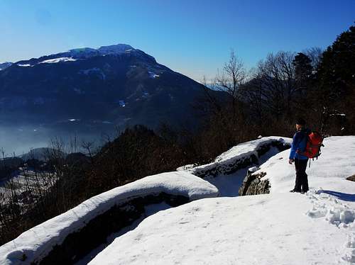
A little further on, cross a mule track that you take to the left entering a long series of well restored trenches built with stones and caverns until you reach the Artillery Observatory, a panoramic spot on Garda Lake. From the observatory one proceeds in the right direction on more open ground until reaching the wide summit prairies overlooking the nearby Monte Stivo and finally the summit cross.
|
|
|
Red Tape
No fees no permits required.
Hiking and scrambling scale
T - Turistico (Tourist): Itineraries on wide, clear and well worn paths, sometimes on mule tracks or gravel roads. The routes are never exposed, don't give any orientation problems and don't exceed 2500 meters of altitude. Suitable also for children
E - Escursionisti (Hikers): Itineraries on marked trails, even narrow and with possible steep and impervious sections. They are never exposed and don't give any orientation problems. They can tread different kinds of ground, such as forests, gravel, meadows, pastures, easy rocks, etc.). They form the majority of the trails that wind up in the mountains and require a certain habit to walk; you need equipment suitable for the altitude and resistant footwear with soles suitable for rough terrain
EE - Escursionisti Esperti (Experienced Hikers): Itineraries for hikers with experience and good knowledge of the mountain. Some of these paths may have exposed sections, however brief, which require firm foot and no dizziness. They require the ability to adapt to particular terrain, such as steep grassy slopes or stretches of rocks with difficulties that can reach the 1st degree of the UIAA scale. They can also reach high altitudes (3000 m or more). Sometimes they may include unmarked sections, requiring a good sense of orientation. Snow slopes are possible, however which can be overcome without specific mountaineering gear (rope, harness, crampons, ice-axe)
EEA - Escursionisti Esperti con Attrezzatura (Experienced Hikers with equipment - The same as EE, in addition these routes require the use of via ferrata equipment (lanyards, harness, carabiners, heat sink, helmet). This kind of itineraries range from the trails with short easy and not much exposed sections, previously equipped with fixed ropes and iron pegs, to the true and more difficult Via Ferratas climbing on rocky walls or on aerial ridges and ledges, previously equipped with long stretches of iron ropes, iron steps, ladders without which proceeding would constitute a real climbing. It is necessary to know how to use the technical equipment and have a certain habit of exposure and mountaineering terrains.
VERSIONE ITALIANA
T - Turistico: itinerari su sentieri ampi, evidenti e ben tracciati, a volte su mulattiere o strade sterrate. I percorsi non sono mai esposti, non danno problemi di orientamento e non superano i 2500 metri di altitudine. Adatti anche ai bambini
E - Escursionisti: itinerari su sentieri segnalati, anche stretti e con possibili tratti ripidi e impervi. Non sono mai esposti e non danno problemi di orientamento. Possono percorrere diversi tipi di terreno, come foreste, ghiaioni, prati, pascoli, facili rocce, ecc.). Costituiscono la maggior parte dei sentieri che si possono incontrare in montagna e richiedono una certa abitudine a camminare. Richiedono inoltre un equipaggiamento adatto all'altitudine e calzature resistenti con suole idoneee ai terreni accidentati
EE - Escursionisti Esperti: itinerari per escursionisti con esperienza e buona conoscenza della montagna. Alcuni di questi percorsi possono presentare sezioni esposte, per quanto brevi, che richiedono piede fermo e assenza di vertigini. Richiedono la capacità di adattarsi a terreni particolari, come ripidi pendii erbosi o tratti rocciosi con difficoltà che possono raggiungere il I grado della scala UIAA. Possono anche raggiungere quote elevate (3000 m o più). A volte possono prevedere tratti non segnalati, che richiedono un buon senso dell'orientamento. Sono possibili pendii nevosi, che possono essere superati senza attrezzatura specifica per l'alpinismo (come corda, imbragatura, ramponi, piccozza)
EEA - Escursionisti Esperti con Attrezzatura - Come l'EE, in più questi percorsi richiedono l'uso di attrezzatura da via ferrata (cordini, imbragatura, moschettoni, dissipatore di calore, casco). Questo tipo di itinerari spazia dai sentieri con brevi tratti facili e poco esposti, dotati di corde fisse e/o pioli di ferro, verso le vere e più difficili Vie Ferrate che affrontano pareti rocciose o creste aeree, dotate di lunghi tratti di corde fisse generalmente in acciaio, gradini di ferro e/o scale senza cui la progressione diventerebbe una vera e propria scalata. È necessario essere a conoscenza delle modalità di utilizzo dell'attrezzatura tecnica e avere una certa abitudine all'esposizione e ai terreni alpinistici.
When to Climb
All year round. The mountain is easily accessible also in wintertime.
|
|
Where to stay
Several possibilities of accomodation in Val Lagarina and Val di Gresta
Bibliography
Meteo Forecast