
-
 14084 Hits
-
 92.32% Score
-
 38 Votes
|
|
Mountain/Rock |
|---|---|
|
|
45.97950°N / 10.91019°E |
|
|
Trentino Alto-Adige |
|
|
Trad Climbing, Sport Climbing, Big Wall |
|
|
Spring, Summer, Fall, Winter |
|
|
2822 ft / 860 m |
|
|
Overview
Cima alle Coste
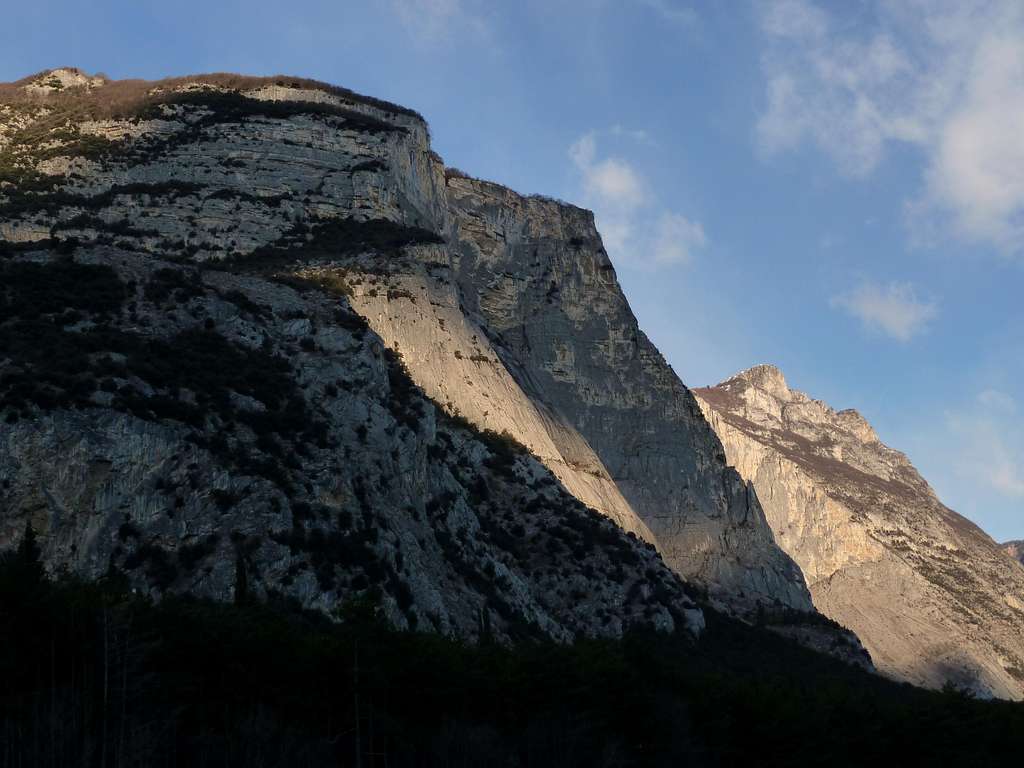
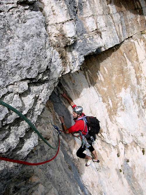
A sun ray lights up The Shield
Cima alle Coste - also called Gran Diedro di Dro (Dro Great Corner) – is a mighty 700 meters high wall situated in the middle mountain area named Sarca Valley, a world famous climbing area and truly an earthly paradise both for trad and sportive climbing, due to the qualikty of the limestone and the mildness of the climate. This mountain shows a peculiar shape, looking like a huge corner well shaped by two tremendous faces: South face, steep and very high, and East face, sloping and more accessible, named “Lo Scudo” (The Shield). Below East Ridge is situated a 300 meter high pillar named Guglia Solidarnosch. Cima alle Coste has three different sectors:
- CENTRAL WALL - LO SCUDO (THE SHIELD) - SOUTH FACE - GUGLIA SOLIDARNOSCH

|

|
While the rock’s quality on South Face may be sometimes not perfect, “The Shield” shows an excellent kind of limestone; for this reason, together with scenery’s amenities, several classic and sportive climbing routes had been realized on these beautiful grey and compact slabs in last years and they’re very frequently climbed.

Getting there
The best starting point is the little town of Dro, 6 km. from Arco di Trento. Road access
From A22 Brennero Motorway exit “Rovereto Sud – Lago di Garda Nord” follow the road 240 towards Riva del Garda, Nago and Arco. Once getting to Arco first round-about turn to right following the road entering Sarca Valley towards Dro and Trento. Once getting to Dro continue on the main for about 3 km., reaching on your left-hand side a narrow road towards Lago Bagattoli. Turn to left following this road and reaching at once a parking area near the small lake (28 km. from Rovereto Sud exit).
Martini-Tranquillini central corner |
Lo Specchio (The Shield) - Nuvole Bianche |
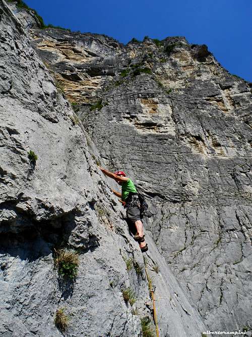
Destinazione Paradiso |
Walking access
From Lago Bagattoli a forestal track towards left enters the little pine’s wood. Once getting the first fork, follow the path on the left, then rise along a steep trail on the right leading towards the wall and reaching a wide and characteristic rocky slope. Scramble on along a ledge crossing these slabs and leading to the base of the wall (0,45 minutes from Lago Bagattoli).

|

|
Grades and Scales
According to Italian climbing areas habit, trad routes grades are expressed in UIAA Scale, while modern ones are in French Scale

Routes overview
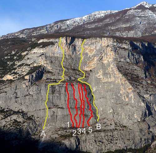
Cima alle Coste and Scudo routes: A Oasi di Pace B Martini-Tranquillini 1 Ummagumma 2 Nuvole Bianche 3 Transeamus 4 Mariposa Libre 5 Zilinder Weg
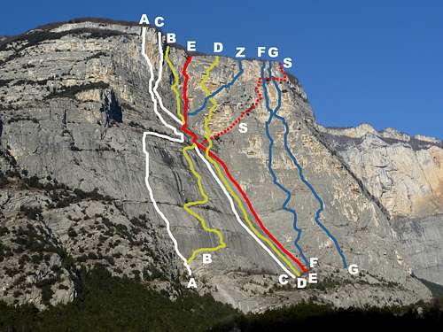
Cima alle Coste Central Wall routes: A Oasi di pace B Sole nascente C Destinazione Paradiso D La luna e i falò E Martini-Tranquillini F Via della Rinascita G Sodoma e Gomorrah Z Clessidre S Steinkotter
CENTRAL WALL - Routes overview from left to right
- Oasi di pace (Oasis of Peace) VII, A1, 650 m. – Trad route M. Bozzetta, M. Furlani 1994
- Specchio di Osiride VII, A1, 600 m. – Trad route A. Zanetti, G. Dalfovo, C. Baratto 1993
- Sole Nascente (Sunrise) VI+, A1, 600 m. – Trad route E. Salvaterra, A. Leviti 1980
- Destinazione Paradiso (Heaven Destination) VII, A1, 600 m. Mixed equipment (bolts and pegs) T. Quecchia, D. Ballerini, C. Stefani, F. Prati, F. Culazzu 1995
- La Luna e i Falò (Moon and Bonfires) VII, A1, 750 m. Mixed equipment (bolts and pegs) S. Scalet, M. Pegoretti, L. Turato, E. Covi 1998
- Martini-Tranquillini V+, VI, 500 m. – Trad route S. Martini, M. Tranquillini, M. Protoni 1972
- Clessidra V+, VI+, 500 mt. – Trad route M. Giordani, R. Manfrini 1985
LO SCUDO (THE SHIELD) - Routes overview from left to right
- Diedro Massimiliano V, VI+, 150 m - Trad route G. Stenghel, A. Baldessari 1982
- Dinosauri 5c, 6a, 6b (or A0), 450 m - Bolts L. Pilati, A. Michelotti 2012
- Passeggiata di Pasqua (Easter Walk) IV+, V+, 300 m – Trad route R. Goedeke, S. Hor 1985
- Mas que Nada 6b, 300 m - Bolts R. Galvagni 2006
- Profondo Bush 6b, 6c, 300 m – Bolts A. Zanetti, C. Groaz 2004
- Casinò Royale 6a, 6b+, 450 m - Bolts D. Filippi, R. Galvagni 2007
- Dino Sottovia V+, VI, 300 m – Trad route C. Paris, M. Pegoretti, E. Degasperi 1981
- Bella Ciao 6a, 6b, 6c 280 m - Bolts R. Galvagni, D. Filippi 2008
- Ummagumma 7a (6a), 280 m. – Bolts G. Dalfovo, A. Conz 1996
- Direttissima VI+, VII, 300 m. – Trad route M. Giordani, F. Zenatti 1982
- Nuvole Bianche 6c (5c obbl.), 300 m. – Bolts S. Bazzanella, D. Filippi, G. Francomanno 1994
- Transeamus 6a, 6b, 280 m. – Bolts R. Galvagni, M. Maceri 2001
- Sesto Grado V+, VI, 300 m – Spaced bolts W. Schonauer, H. Long, K. Zehedner 1994
- Mariposa Libre (Free Butterfly) 6a, 280 m. - Bolts R. Galvagni, D. Filippi 2007
- Amici del Sottobosco 5c, 6a, 280 m - Bolts R. Galvagni, D. Filippi 2010
- Zilinder Weg V+, VI, 280 m. – Trad route L. Reiser, H. Enthofer 1981
- Via della Mezza Luna (Half-Moon) VI+, A1, 250 m – Trad route D. Filippi 1993

|

|

|

|
SOUTH FACE - Routes overview from left to right
- Steinkotter
– Holzer - Messner V+, VI, 700 m – Trad route H. Steinkotter, H. Holzer, R. Messner 1966
- Via della Rinascita VI+, VII, 650 m – Trad route M. Giordani, F. Zenatti 1983
- Sodoma e Gomorrah VI+, VII, 650 m – Trad route L. Reiser, R. Sulzenbacher 1982
- Pipistrei VI+, VII, A0, 650 m T. Zanetti, F. Sartori, G. Bonvecchio 2011
GUGLIA SOLIDARNOSCH - Routes overview from left to right
- Via del Camino IV, V, 200 m - Trad route
- Via dei Tipografi (Typographers’ Route) IV, V+, 300 mt. – Trad route A. Andreotti, D. Zenatti, G. Stenghel 1980
- Tinto Brass 5a, 6a, 6b (a move), 400 m - Bolts R. Galvagni, M. Maceri 2007
- Buon Natale 2008 6b, 7a, 350 m - Bolts I. Feller, C. Masera 2008
- Marina IV, V+, VII, 250 m – Trad route G. Stenghel, A. Baldessari 1981
Descent from Central and South faces - Cross the summit wood heading towards West and reaching a flat path. Follow it towards South, then follow towards SW a forest road for about 600 meters leading to a fork on a hill. Descent left reaching the path n. 425 towards Dro, leading to the bottom of Sarca valley.
Descent from The Shield - Abseiling the routes
History
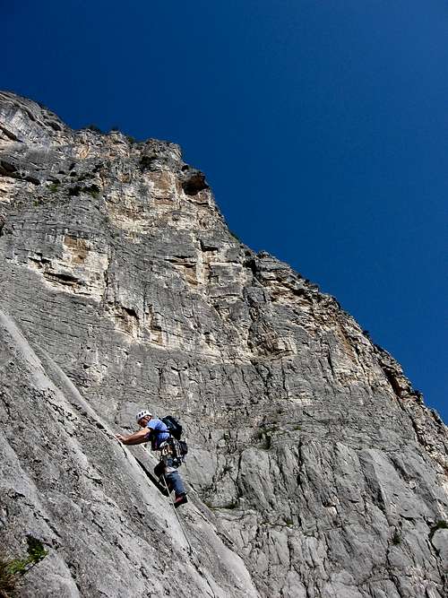
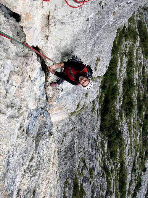
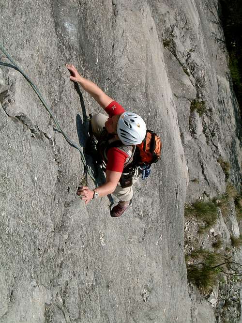
The Shield, Nuvole Bianche |
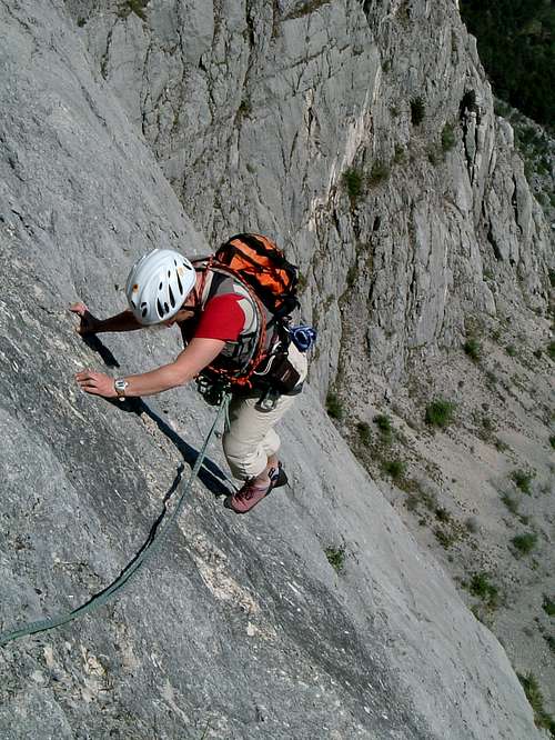
Central Wall, Martini-Tranquillini classic route |
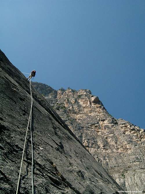
Abseil on The Shield |
The first ascent of the wall was realized by Heinz Steinkotter, Heini Holzer and Reinhold Messner in 1966, climbing an explorative 700 meter drop route having an enormous historic worth, but today rarely climbed.

|

|

|

|

|

|
Red Tape
There are no restrictions in climbing and hiking.
Climate and nature
Due to the Garda Lake’s propitious influence and the area’s limited altitude, the climate is very mild and it’s possible to climb in all seasons. Nature is magnificent, showing a pleasant marriage of Mediterranean flora and alpine one.
When to climb
All year round.
Where to stay
This area is a primary touristic destination, offering several hotels, agriturismo and bed and breakfast, renting rooms and apartments in Arco, Dro, Pietramurata and Ceniga.

Campings in Arco and Pietramurata.
Meteo
Guidebooks and Maps
 |
 |
 |
- Guidebooks
“Pareti del Sarca” by Diego Filippi – Edizioni Versante Sud "Arco Pareti" by Diego Filippi - Edizioni Versante Sud 2013
- Maps
“Valle del Sarca” – Map 1.25.000 - Edizioni Meridiani Montagne
External Links
Useful informations here: